Thonotosassa, Florida

Last updated

Thonotosassa, Florida
ThonotosassaPostOffice2.jpg
Post office
Hillsborough County Florida Incorporated and Unincorporated areas Thonotosassa Highlighted.svg
Location in Hillsborough County and the state of Florida
Coordinates: 28°3′22″N82°17′34″W / 28.05611°N 82.29278°W / 28.05611; -82.29278
Country United States
State Florida
County Hillsborough
Area
[1]
  Total28.33 sq mi (73.37 km2)
  Land26.48 sq mi (68.59 km2)
  Water1.84 sq mi (4.78 km2)
Elevation
33 ft (10 m)
Population
 (2020)
  Total15,238
  Density540/sq mi (210/km2)
Time zone UTC-5 (Eastern (EST))
  Summer (DST) UTC-4 (EDT)
ZIP code
33592
Area code 813
FIPS code 12-71725 [2]
GNIS feature ID0292232 [3]

Thonotosassa is a census-designated place (CDP) in Hillsborough County, Florida, United States. The population was 15,238 at the 2020 census, [4] up from 13,014 at the 2010 census. [5]

Contents

History

A black bear at Nature's Classroom; October 2013 Black bear at Nature's Classroom.jpg
A black bear at Nature's Classroom; October 2013

The name "Thonotosassa" comes from the Seminole-Creek words ronoto "flint" and sasv "some", meaning the place was a source of valuable flint. [6] Following the establishment of Fort Brooke in 1824 in what is now Tampa, a road that ran northwest of Lake Thonotosassa was built between Fort Brooke and Fort King in Ocala. This road became known as the Fort King Road, which today is crossed in several locations by U.S. Route 301. [7] Nevertheless, the presence of a Seminole village largely discouraged whites from moving into the area. After the Second Seminole War ended in 1842, whites began to settle.

In 1893, the Tampa and Thonotosassa Railroad opened a 13-mile (21 km) route between the two growing communities. [8] This line today no longer extends into Thonotosassa, its northern tracks having been removed along with the town depot by the 1980s, [9] but its southern portion remains a busy industrial spur, joining with the CSX main line at Neve Wye.

Among other areas for recreation for the youth is the Morris Bridge Road area and its Nature's Classroom. [10]

Geography

Thonotosassa is located in northeastern Hillsborough County at 28°3′22″N82°17′34″W / 28.05611°N 82.29278°W / 28.05611; -82.29278 (28.056135, -82.292663). [11] It is bordered to the southwest by East Lake-Orient Park, and to the south by Mango and Seffner. The unincorporated community of Antioch is on the eastern edge of the CDP.

The Hillsborough River forms the northern edge of the CDP, Interstate 4 forms the southern edge, and Interstate 75 forms the western edge. I-4 leads east 24 miles (39 km) to Lakeland and west 11 miles (18 km) to downtown Tampa, while I-75 leads north 90 miles (140 km) to Ocala and south 46 miles (74 km) to Bradenton. U.S. Route 301 travels through the northern part of Thonotosassa, leading northeast 15 miles (24 km) to Zephyrhills and south 16 miles (26 km) to Riverview.

According to the United States Census Bureau, the CDP has a total area of 28.3 square miles (73.4 km2), of which 26.5 square miles (68.6 km2) are land and 1.9 square miles (4.8 km2), or 6.51%, are water. [5] It is 40 feet (12 m) above sea level. Plant City is 13 miles (21 km) to the east.

Demographics

Historical population
CensusPop.Note
2000 6,091
2010 13,014113.7%
2020 15,23817.1%
source: [4]

As of the census [2] of 2000, there were 6,091 people, 2,178 households, and 1,616 families residing in the community. The population density was 365.5 inhabitants per square mile (141.1/km2). There were 2,532 housing units at an average density of 151.9 per square mile (58.6/km2). The racial makeup of the community was 90.63% White, 4.94% African American, 0.51% Native American, 0.38% Asian, 0.03% Pacific Islander, 1.79% from other races, and 1.72% from two or more races. Hispanic or Latino of any race were 6.29% of the population.

There were 2,178 households, out of which 34.9% had children under the age of 18 living with them, 55.6% were married couples living together, 12.2% had a female householder with no husband present, and 25.8% were non-families. 20.1% of all households were made up of individuals, and 8.1% had someone living alone who was 65 years of age or older. The average household size was 2.72 and the average family size was 3.07.

In the community the population was spread out, with 26.7% under the age of 18, 7.6% from 18 to 24, 28.6% from 25 to 44, 23.1% from 45 to 64, and 14.0% who were 65 years of age or older. The median age was 37 years. For every 100 females, there were 99.6 males. For every 100 females age 18 and over, there were 95.4 males.

The median income for a household in the community was $43,159, and the median income for a family was $44,829. Males had a median income of $31,914 versus $22,674 for females. The per capita income for the community was $18,191. About 12.7% of families and 16.0% of the population were below the poverty line, including 23.2% of those under age 18 and 17.4% of those age 65 or over.

Education

Public schools

Elementary schools

  • Folsom Elementary School
  • Thonotosassa Elementary School

Charter schools

Libraries

Related Research Articles

<span class="mw-page-title-main">Bloomingdale, Florida</span> Census-designated place in Florida, United States

Bloomingdale is an unincorporated census-designated place in Hillsborough County, Florida, United States. The population was 22,711 at the 2010 census. The ZIP Codes serving the community are 33511 and 33596.

<span class="mw-page-title-main">Cheval, Florida</span> Census-designated place in Florida, United States

Cheval is a census-designated place in Hillsborough County, Florida, United States. The population was 10,702 at the 2010 census, up from 7,602 at the 2000 census.

<span class="mw-page-title-main">Citrus Park, Florida</span> Census-designated place in Florida, United States

Citrus Park is an unincorporated census-designated place in Hillsborough County, Florida, United States. The population was 28,178 at the 2020 census, up from 24,252 at the 2010 census.

<span class="mw-page-title-main">East Lake-Orient Park, Florida</span> Census-designated place in Florida, United States

East Lake-Orient Park is an unincorporated census-designated place in Hillsborough County, Florida, United States. The population was 22,753 at the 2010 census, up from 5,703 at the 2000 census following an expansion of its borders. The area is the home of the Florida State Fairgrounds, which hosts the Florida State Fair in mid-February of each year. It was previously home to East Lake Square Mall. The ZIP code for East Lake-Orient Park is 33610 and 33619.

<span class="mw-page-title-main">Egypt Lake-Leto, Florida</span> Census-designated place in Florida, United States

Egypt Lake-Leto is a census-designated place in an unincorporated part of Hillsborough County, Florida, United States. The population was 36,644 as of the 2020 census. The area is located just north of Tampa International Airport. The ZIP code for Egypt Lake-Leto is 33614.

<span class="mw-page-title-main">Northdale, Florida</span> Census-designated place in Florida, United States

Northdale is an unincorporated census-designated place in Hillsborough County, Florida, United States. Northdale was named by the combination of the words in North Dale Mabry, the main highway through the Northdale area. The population was 22,079 at the 2010 census.

<span class="mw-page-title-main">Keystone, Florida</span> Census-designated place in Florida, United States

Keystone is an unincorporated census-designated place in Hillsborough County, Florida, United States. The Keystone area was first settled in the middle 1800s by the W.M. Mobley Family who migrated from Savannah, Georgia. The region has evolved from citrus and farming into a rural retreat of many lake homes and ranches. The population was 24,039 at the 2010 census, up from 14,627 at the 2000 census. The ZIP Codes encompassing the CDP area are 33556 and 33558.

<span class="mw-page-title-main">Lake Magdalene, Florida</span> Census-designated place in Florida, United States

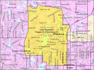
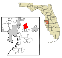
Lake Magdalene is a census-designated place (CDP) in Hillsborough County, Florida, United States. The population was 28,509 at the 2010 census.

<span class="mw-page-title-main">Lutz, Florida</span> Unincorporated Community in Florida, United States

Lutz is an unincorporated community in Hillsborough County and Pasco County, Florida, United States, 15 miles (24 km) north of Tampa. While there is a census-designated area of Lutz, the community itself extends beyond those boundaries into other census-designated areas.

<span class="mw-page-title-main">Mango, Florida</span> Census-designated place in Florida, United States

Mango is a census-designated place (CDP) in Hillsborough County, Florida, United States. The population was 11,313 at the 2010 census, up from 8,842 at the 2000 census.

<span class="mw-page-title-main">Palm River-Clair Mel, Florida</span> Census-designated place in Florida, United States

Palm River-Clair Mel is a census-designated place (CDP) in Hillsborough County, Florida, United States. The population was 21,024 at the 2010 census, up from 17,589 at the 2000 census. The census area includes the unincorporated communities of Clair-Mel City and Palm River. The ZIP code for Palm River-Clair Mel is 33619.

<span class="mw-page-title-main">Pebble Creek, Florida</span> Census-designated place in Florida, United States

Pebble Creek is a census-designated place (CDP) in Hillsborough County, Florida, United States. The population was 9,624 at the 2020 census, up from 7,622 at the 2010 census. Pebble Creek is located in the unincorporated portion of New Tampa, and is primarily a residential zone.

<span class="mw-page-title-main">Progress Village, Florida</span> Census-designated place in Florida, United States

Progress Village is a census-designated place (CDP) in Hillsborough County, Florida, United States. Per the 2020 census, the population was 11,188.

<span class="mw-page-title-main">Seffner, Florida</span> Census-designated place in Florida, United States

Seffner is a census-designated place (CDP) in Hillsborough County, Florida, United States. The population at the 2020 census was 8,362, up from 7,579 at the 2010 census.

<span class="mw-page-title-main">Town 'n' Country, Florida</span> Census-designated place in Florida, United States

Town 'n' Country is a census-designated place (CDP) in Hillsborough County, Florida, United States. The population was 85,951 at the 2020 census.

<span class="mw-page-title-main">University, Hillsborough County, Florida</span> Census-designated place in Florida, United States

University is an unincorporated census-designated place in Hillsborough County, Florida, United States. The population was 41,163 at the 2010 census, up from 30,736 at the 2000 census. The University of South Florida is located just southeast of the community, within the Tampa city limits. The community is also known as "University West", mainly due to its location in relation to the university. The community is often notoriously referred to by locals as "Suitcase City" due to the high rate of transients.

<span class="mw-page-title-main">Odessa, Florida</span> CDP in Florida, United States

Odessa is a census-designated place (CDP) in Pasco County, Florida, United States. The population was 3,173 at the 2000 census and more than doubled to 7,267 in 2010. Northwest of Tampa, Odessa had been an area of open spaces, ranching, and horse properties. More recently it has seen many suburban property developments as Tampa's population expands.

<span class="mw-page-title-main">Trinity, Florida</span> CDP in Florida, United States

Trinity is a census-designated place (CDP) in Pasco County, Florida, United States. The population was 10,907 in 2010, according to the most recent census. The Trinity Community is named after Trinity College of Florida, a Bible college founded in 1932, when it relocated to the first occupied site in the communities developed by James Gills in the late 1980s. The main plaza is found near the high school, known as Mitchell Ranch Plaza. Trinity is located at the junction where Pasco, Hillsborough and Pinellas Counties meet. The community of Longleaf is located in Trinity and it is believed that the “Welcome Plank” originated in Longleaf.

<span class="mw-page-title-main">Carrollwood (CDP), Florida</span> Census-designated place in Florida, United States

Carrollwood is a census-designated place (CDP) in northwestern Hillsborough County, Florida, United States. The population was 33,365 at the 2010 census. The census area includes the unincorporated communities of Carrollwood and Carrollwood Village. For the 2000 census the area was enumerated under the name "Greater Carrollwood" and had a population of 33,519. A similar area was listed as "Lake Carroll" in 1970 and 1980; for the 1990 census it was split into the smaller Carrollwood and Carrollwood Village CDPs.

<span class="mw-page-title-main">Sun City Center, Florida</span> Census-designated place in Florida, United States

Sun City Center is an unincorporated census-designated place (CDP) in southern Hillsborough County, Florida, United States. It is located south of Tampa and north of Sarasota on I-75. As of the 2020 census, the population was 30,952. The ZIP Code serving the community is 33573.

References

  1. "2020 U.S. Gazetteer Files". United States Census Bureau. Retrieved December 2, 2021.
  2. 1 2 "U.S. Census website". United States Census Bureau . Retrieved January 31, 2008.
  3. "US Board on Geographic Names". United States Geological Survey. October 25, 2007. Retrieved January 31, 2008.
  4. 1 2 "Census of Population and Housing". U.S. Census Bureau . Retrieved January 21, 2013.
  5. 1 2 "Geographic Identifiers: 2010 Demographic Profile Data (G001): Thonotosassa CDP, Florida". American Factfinder. U.S. Census Bureau. Retrieved May 5, 2017.[ dead link ]
  6. Martin, Jack B.; Mauldin, Margaret Mckane (December 2004). A Dictionary of Creek/Muskogee. ISBN   0803283024.
  7. "History of Pasco County - Fort King Road". fivay.org. Retrieved September 15, 2016.
  8. Turner, G. A Short History of Florida Railroads, page 65. Arcadia Publishing, 2003.
  9. Mulligan, M. Railroad Depots of Central Florida, page 53. Arcadia Publishing, 2008.
  10. "NameBright - Coming Soon". Naturesclassroom.net. Retrieved May 18, 2017.
  11. "US Gazetteer files: 2010, 2000, and 1990". United States Census Bureau. February 12, 2011. Retrieved April 23, 2011.

Thonotosassa at Curlie