"Erech" redirects here. For the fictional location in the works of J. R. R. Tolkien, see Erech (Middle-earth). For the fictional monsters in the same works, see Uruk-hai.
Uruk, the archeological site known today as Warka, was an ancient city in the Near East or West Asia, located east of the current bed of the Euphrates River, on an ancient, now-dried channel of the river in Muthanna Governorate, Iraq. The site lies 93 kilometers (58 miles) northwest of ancient Ur, 108 kilometers (67 miles) southeast of ancient Nippur, and 24 kilometers (15 miles) northwest of ancient Larsa.[1]
Uruk is the type site for the Uruk period. Uruk played a leading role in the early urbanization of Sumer in the mid-4th millennium BC. By the final phase of the Uruk period around 3100 BC, the city may have had 40,000 residents,[2] with 80,000–90,000 people living in its environs,[3] making it the largest urban area in the world at the time. Gilgamesh, according to the chronology presented in the Sumerian King List (SKL), ruled Uruk in the 27th century BC. After the end of the Early Dynastic period, with the rise of the Akkadian Empire, the city lost its prime importance. It had periods of florescence during the Isin-Larsa period, Neo-Assyrian and Neo-Babylonian periods and throughout the Achaemenid (550–330 BC), Seleucid (312–63 BC) and Parthian (227 BC to AD 224) periods, until it was finally abandoned shortly before or after the Islamic conquest of 633–638. William Kennett Loftus visited the site of Uruk in 1849, identifying it as "Erech", known as "the second city of Nimrod", and led the first excavations from 1850 to 1854.[4][5]
Toponymy
Uruk (/ˈʊrʊk/) has several spellings in cuneiform. In Sumerian, it is 𒀕𒆠unugᵏⁱ,[6] and in Akkadian, it is spelled 𒌷𒀕 or 𒌷𒀔Uruk (URUUNUG). In Arabic, it is called وركاء (Warkāʾ) or أوروك (Auruk); in Syriac, ܐܘܿܪܘܿܟ (ʾÚrūk); and in Biblical Hebrew, אֶרֶךְ (ʾÉreḵ). In Ancient Greek, it was known as Ὀρχόη (Orkhóē), Ὀρέχ (Orékh), and Ὠρύγεια (Ōrúgeia).
History
Devotional scene to Inanna, Warka Vase, c. 3200–3000 BC, Uruk. This is one of the earliest surviving works of narrative relief sculpture.
According to the SKL, Uruk was founded by the king Enmerkar. Though the king-list mentions a father before him, the epic Enmerkar and the Lord of Aratta relates that Enmerkar constructed the House of Heaven (Sumerian: e₂-anna; cuneiform: 𒂍𒀭 E₂.AN) for the goddess Inanna in the Eanna District of Uruk. In the Epic of Gilgamesh, Gilgamesh builds the city wall around Uruk and is king of the city.
Uruk went through several phases of growth, from the Early Uruk period (4000–3500BC) to the Late Uruk period (3500–3100BC).[1] The city was formed when two smaller Ubaid settlements developed into the cities of Unug and Kullaba and later merged to become Uruk. The temple complexes at their cores became the Eanna District (Unug) dedicated to Inanna and the "Anu" District of Kullaba.[1]
The Eanna District comprised several buildings with workshop spaces and was walled off from the city. By contrast, the Anu District was built on a terrace with a temple at the top. It is clear Eanna was dedicated to Inanna from the earliest Uruk period throughout the history of the city.[7] The rest of the city was composed of typical courtyard houses, grouped by profession of the occupants, in districts around Eanna and Anu. Uruk was extremely well penetrated by a canal system that has been described as "Venice in the desert".[8] This canal system flowed throughout the city connecting it with the maritime trade on the ancient Euphrates River as well as the surrounding agricultural belt.
The original city of Uruk was situated southwest of the ancient Euphrates River. Today, the site of Warka is northeast of the river. The change in position was caused by a shift in the Euphrates at some point in history, which, together with salinization from irrigation, may have contributed to the decline of Uruk.[citation needed]
Uruk period
Uruk expansion and colonial outposts, c.3600–3200 BC
In addition to being one of the first cities, Uruk was the main force of urbanization and state formation during the Uruk period, or 'Uruk expansion' (4000–3200 BC). This period of 800years saw a shift from small, agricultural villages to a larger urban center with a full-time bureaucracy, military, and stratified society. Although other settlements coexisted with Uruk, they were generally about 10 hectares while Uruk was significantly larger and more complex. The Uruk period culture exported by Sumerian traders and colonists influenced all surrounding peoples, who gradually evolved their own comparable, competing economies and cultures. Ultimately, Uruk could not maintain long-distance control over colonies such as Tell Brak by military force.
Early Dynastic, Akkadian, Ur III, and Old Babylonian period
Clay impression of a cylinder seal with monstrous lions and lion-headed eagles, Mesopotamia, Uruk Period (4100–3000 BC). Louvre Museum.Foundation peg of Lugal-kisalsi, king of Uruk, Ur and Kish, circa 2380 BC. The inscription reads "For (goddess) Namma, wife of (the god) An, Lugalkisalsi, King of Uruk, King of Ur, erected this temple of Namma". Pergamon Museum VA 4855.Dedication tablet of Sîn-gāmil, ruler of Uruk, 18th century BC
Dynastic categorizations are described solely from the Sumerian King List, which is of problematic historical accuracy;[9][10] the organization might be analogous to Manetho's.
In 2009, two different copies of an inscription were put forth as evidence of a 19th-century BC ruler of Uruk named Naram-sin.[11]
Uruk continued as a principality of Ur, Babylon, and later Achaemenid, Seleucid, and Parthian Empires. It enjoyed brief periods of independence during the Isin-Larsa period, under kings such as (possibly Ikūn-pî-Ištar, Sumu-binasa, Alila-hadum, and Naram-Sin), Sîn-kāšid, his son Sîn-irībam, his son Sîn-gāmil, Ilum-gāmil, brother of Sîn-gāmil, Etēia, AN-am3 (Dingiram), ÌR3-ne-ne (Irdanene), who was defeated by Rīm-Sîn I of Larsa in his year 14 (c. 1740BC), Rîm-Anum and Nabi-ilīšu.[12][11][13][14][15]
It is known that during the time of Ilum-gāmil a temple was built for the god Iškur (Hadad) based on a clay cone inscription reading "For the god Iškur, lord, fearsome splendour of heaven and earth, his lord, for the life of Ilum-gāmil, king of Uruk, son of Sîn-irībam, Ubar-Adad, his servant, son of Apil-Kubi, built the Esaggianidu, ('House — whose closing is good'), the residence of his office of en, and thereby made it truly befitting his own li[fe]".[12]
Uruk into Late Antiquity
Foundation tablet from the Temple of Inanna at Uruk (Eanna), dating to the reign of Ur-Nammu
Although it had been a thriving city in Early Dynastic Sumer, especially Early Dynastic II, Uruk was ultimately annexed by the Akkadian Empire and went into decline. Later, in the Neo-Sumerian period, Uruk enjoyed a revival as a major economic and cultural center under the sovereignty of Ur. The Eanna District was restored as part of an ambitious building program, which included a new temple for Inanna. This temple included a ziggurat, the 'House of the Universe' (Cuneiform: E₂.SAR.A) (𒂍𒊬𒀀) to the northeast of the Uruk period Eanna ruins.
Following the collapse of Ur (c. 2000BC), Uruk went into a steep decline until about 850BC when the Neo-Assyrian Empire annexed it as a provincial capital. Under the Neo-Assyrians and Neo-Babylonians, Uruk regained much of its former glory. By 250BC, a new temple complex, the 'Head Temple' (Akkadian: Bīt Reš), was added northeast of the Uruk-period Anu district. The Bīt Reš along with the Esagila was one of the two main centers of Neo-Babylonian astronomy. All of the temples and canals were restored again under Nabopolassar. During this era, Uruk was divided into five main districts: the Adad Temple, Royal Orchard, Ištar Gate, Lugalirra Temple, and Šamaš Gate districts.[16]
Uruk, known as Orcha (Ὄρχα) to the Greeks, continued to thrive under the Seleucid Empire. During this period, Uruk was a city of 300hectares and perhaps 40,000 inhabitants.[16][17][18] In 200BC, the 'Great Sanctuary' (Cuneiform: E₂.IRI₁₂.GAL, Sumerian: eš-gal) of Ishtar was added between the Anu and Eanna districts. The ziggurat of the temple of Anu, which was rebuilt in this period, was the largest ever built in Mesopotamia.[18] When the Seleucids lost Mesopotamia to the Parthians in 141 BC, Uruk continued in use.[19] The decline of Uruk after the Parthians may have been in part caused by a shift in the Euphrates River. By 300AD, Uruk was mostly abandoned, but a group of Mandaeans settled there, based on some finds of Mandaicincantation bowls, and by c.700 AD it was completely abandoned.[20]
Uruk played a very important part in the political history of Sumer. From the Early Uruk period onward, the city exerted hegemony over nearby settlements. At this time (c.3800BC), there were two centers of 20ha (49 acres), Uruk in the south and Nippur in the north surrounded by much smaller 10ha (25 acres) settlements.[23] Later, in the Late Uruk period, its sphere of influence extended over all Sumer and beyond to external colonies in upper Mesopotamia and Syria.
In Uruk, in southern Mesopotamia, Sumerian civilization seems to have reached its creative peak. This is pointed out repeatedly in the references to this city in religious and, especially, in literary texts, including those of mythological content; the historical tradition as preserved in the Sumerian king-list confirms it. From Uruk the center of political gravity seems to have moved to Ur.
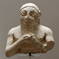
Probable Uruk King-Priest with a beard and hat (c. 3300 BC, Uruk). Louvre.
The recorded chronology of rulers of Uruk includes both mythological and historical figures across five dynasties. As in the rest of Sumer, power moved progressively from the temple to the palace. Rulers from the Early Dynastic period exercised control over Uruk and, at times, over all of Sumer. In myth, kingship was brought down from heaven to Eridu, then passed through five cities in succession until the deluge, which ended the Uruk period. Afterwards, kingship passed to Kish at the beginning of the Early Dynastic period, which corresponds to the beginning of the Early Bronze Age in Sumer. In the Early Dynastic I period (2900–2800BC), Uruk was in theory under the control of Kish. This period is sometimes called the Golden Age. During the Early Dynastic II period (2800–2600BC), Uruk was again the dominant city exercising control of Sumer. This period corresponds to the First Dynasty of Uruk, also known as the Heroic Age. However, by the Early Dynastic IIIa period (2600–2500BC) Uruk had lost sovereignty, this time to Ur. This period, corresponding to the Early Bronze Age III, is the end of the First Dynasty of Uruk. In the Early Dynastic IIIb period (2500–2334BC), also called the Pre-Sargonic period (before the rise of the Akkadian Empire under Sargon of Akkad), Uruk remained under Ur's rule.
Architecture
Relief on the front of the Inanna temple of Karaindash from Uruk. Mid 15th century BC. Pergamon Museum, Berlin.The Parthian Temple of Charyios at Uruk
Uruk has some of the first monumental constructions in architectural history, and certainly the largest of its era. Much of Near Eastern architecture can trace its roots to these prototypical buildings. The structures of Uruk are cited under two different naming conventions: one in German from the initial expedition and the English translation of the same. The site's stratigraphy is complex, and as a result, much of the dating is disputed. In general, the structures follow the two main typologies of Sumerian architecture: Tripartite, with three parallel halls, and T-Shaped, with three halls, with the central hall extending into two perpendicular bays at one end. The following table summarizes the significant architecture of the Eanna and Anu Districts.[26] Temple N, the Cone-Mosaic Courtyard, and the Round Pillar Hall are often referred to as a single structure: the Cone-Mosaic Temple.
Eanna district: 4000–3000BC
Structure name
German name
Period
Typology
Material
Area in m²
Stone-Cone Temple
Steinstifttempel
Uruk VI
T-shaped
Limestone and bitumen
x
Limestone Temple
Kalksteintempel
Uruk V
T-shaped
Limestone and bitumen
2373
Riemchen Building
Riemchengebäude
Uruk IVb
unique
Adobe brick
x
Cone-Mosaic Temple
Stiftmosaikgebäude
Uruk IVb
unique
x
x
Temple A
Gebäude A
Uruk IVb
Tripartite
Adobe brick
738
Temple B
Gebäude B
Uruk IVb
Tripartite
Adobe brick
338
Temple C
Gebäude C
Uruk IVb
T-shaped
Adobe brick
1314
Temple/Palace E
Gebäude E
Uruk IVb
unique
Adobe brick
2905
Temple F
Gebäude F
Uruk IVb
T-shaped
Adobe brick
465
Temple G
Gebäude G
Uruk IVb
T-shaped
Adobe brick
734
Temple H
Gebäude H
Uruk IVb
T-shaped
Adobe brick
628
Temple D
Gebäude D
Uruk IVa
T-shaped
Adobe brick
2596
Room I
Gebäude I
Uruk V
x
x
x
Temple J
Gebäude J
Uruk IVb
x
Adobe brick
x
Temple K
Gebäude K
Uruk IVb
x
Adobe brick
x
Temple L
Gebäude L
Uruk V
x
x
x
Temple M
Gebäude M
Uruk IVa
x
Adobe brick
x
Temple N
Gebäude N
Uruk IVb
unique
Adobe brick
x
Temple O
Gebäude O
x
x
x
x
Hall Building/Great Hall
Hallenbau
Uruk IVa
unique
Adobe brick
821
Pillar Hall
Pfeilerhalle
Uruk IVa
unique
x
219
Bath Building
Bäder
Uruk III
unique
x
x
Red Temple
Roter Tempel
Uruk IVa
x
Adobe brick
x
Great Court
Großer Hof
Uruk IVa
unique
Burnt Brick
2873
Rammed-Earth Building
Stampflehm
Uruk III
unique
x
x
Round Pillar Hall
Rundpeifeilerhalle
Uruk IVb
unique
Adobe brick
x
Anu district: 4000–3000BC
Stone Building
Steingebäude
Uruk VI
unique
Limestone and bitumen
x
White Temple
x
Uruk III
Tripartite
Adobe brick
382
It is clear that Eanna was dedicated to Inanna, symbolized by Venus from the Uruk period. At that time, she was worshipped in four aspects as Inanna of the netherworld (Sumerian: ᵈinanna-kur), Inanna of the morning (Sumerian: ᵈinanna-hud₂), Inanna of the evening (Sumerian: ᵈinanna-sig), and Inanna (Sumerian: ᵈinanna-NUN).[7] The names of four temples in Uruk at this time are known, but it is impossible to match them with either a specific structure and in some cases a deity.[7]
sanctuary of Inanna (Sumerian: eš-ᵈinanna)
sanctuary of Inanna of the evening (Sumerian: eš-ᵈinanna-sig)
temple of heaven (Sumerian: e₂-an)
temple of heaven and netherworld (Sumerian: e₂-an-ki)
Architecture of Uruk
Plan of Eanna VI–V
Plan of Eanna IVb
Plan of Eanna IVa
Plan of Eanna III
Plan of Neo-Sumerian Eanna
Plan of Anu District Phase E
Reconstruction of a mosaic from the Eanna temple
Detail of Reconstruction of a mosaic from the Eanna temple
By the end of the Uruk period c. 3100 BC) Uruk had reached a size of 250ha (620 acres). During the following Jemdet Nasr period it grew to a size of 600ha (1,500 acres) by c. 2800 BC with the main temple area of Eanna being completely rebuilt after leveling the foundations of the Uruk period construction.[27] A new city wall was constructed in this period.[28]
The site, which lies about 50 miles (80km) northwest of ancient Ur, is one of the largest in the region at around 5.5km2 (2.1sqmi) in area. The maximum extent is 3km (1.9 miles) north/south, and 2.5km (1.6 miles) east/west. There are three major tells within the site: The Eanna district, Bit Resh (Kullaba), and Irigal. Archaeologically, the site is divided into six parts
the É-Anna ziggurat ' Egipar-imin,
the É-Anna enclosure (Zingel),
the Anu-Antum temple complex, BitRes and Anu-ziggurat,
Irigal, the South Building,
Parthian structures including the Gareus-temple, and the Multiple Apse building,
the "Gilgameš" city-wall with associated Sinkâsid Palace and the Seleucid Bit Akîtu.[29]
Reconstruction video of Uruk (English subtitles)
The location of Uruk was first noted by Fraser and Ross in 1835.[30]William Loftus excavated there in 1850 and 1854 after a scouting mission in 1849. By Loftus' own account, he admits that the first excavations were superficial at best, as his financiers forced him to deliver large museum artifacts at a minimal cost.[4] A large basalt stela found by Loftus was later lost.[31] Warka was also scouted by archaeologist Walter Andrae in 1902.[32] In 1905 Warka was visited by archaeologist Edgar James Banks.[33]
Male deity pouring a life-giving water from a vessel. Facade of Inanna Temple at Uruk, Iraq. 15th century BC. The Pergamon Museum.
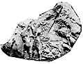
From 1912 to 1913, Julius Jordan and his team from the German Oriental Society discovered the temple of Ishtar, one of four known temples located at the site. The temples at Uruk were quite remarkable as they were constructed with brick and adorned with colorful mosaics. Jordan also discovered part of the city wall. It was later discovered that this 40-to-50-foot (12 to 15m) high brick wall, probably utilized as a defense mechanism, totally encompassed the city at a length of 9km (5.6mi). Utilizing sedimentary strata dating techniques, this wall is estimated to have been erected around 3000 BC. Jordan produced a contour map of the entire site.[28] The GOS returned to Uruk in 1928 and excavated until 1939, when World War II intervened. The team was led by Jordan until 1931 when Jordan became Director of Antiquities in Baghdad, then by A. Nöldeke, Ernst Heinrich, and H. J. Lenzen.[34][35] Among the finds was the Stell of the Lion Hunt, excavated in a Jemdat Nadr layer but sylistically dated to Uruk IV.[36]
The German excavations resumed after the war and were under the direction of Heinrich Lenzen from 1954 to 1967.[37][38][39] He was followed in 1968 by J. Schmidt, and in 1978 by R.M. Boehmer.[40][41] In total, the German archaeologists spent 39 seasons working at Uruk. The results are documented in two series of reports:
Ausgrabungen der Deutschen Forschungsgemeinschaft in Uruk (ADFU), 17 volumes, 1912–2001
Ausgrabungen in Uruk-Warka, Endberichte (AUWE), 25 volumes, 1987–2007
Most recently, from 2001 to 2002, the German Archaeological Institute team led by Margarete van Ess, with Joerg Fassbinder and Helmut Becker, conducted a partial magnetometer survey in Uruk. In addition to the geophysical survey, core samples and aerial photographs were taken. This was followed up with high-resolution satellite imagery in 2005.[42] Work resumed in 2016 and is currently concentrated on the city wall area and a survey of the surrounding landscape.[43][44][45] Part of the work has been to create a digital twin of the Uruk archaeological area.[46] The current effort also involves geophysical surveying. The soil characteristics of the site make ground penetrating radar unsuitable so caesium magnetometers, combined with electrical resistivity probes, are being used.[47] Afterward 25 sediment cores, up to 13 meters deep, were done in 2024 and 2025 and a virtual geophysical topology of the Uruk area was produced.[48][49]
Cuneiform tablets
A massive ziggurat dating from the 4th millennium BC stands at the entrance to Uruk (Warka), 39 km east of Samawah, Iraq
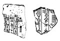
A number of Proto-cuneiform clay tablets were found at Uruk. Around 190 were Uruk V period (c. 3500 BC) "numerical tablets" or "impressed tablets", 1776 were from the Uruk IV period (c. 3300 BC), 3,094 from the Uruk III period (c. 3200–2900 BC) which is also called the Jemdet Nasr period.[50][51] Later cuneiform tablets were deciphered and include the famous SKL, a record of kings of the Sumerian civilization. There was an even larger cache of legal and scholarly tablets of the Neo-Babylonian, Late Babylonian, and Seleucid period, that have been published by Adam Falkenstein and other Assyriological members of the German Archaeological Institute in Baghdad as Jan J. A. Djik,[52]Hermann Hunger, Antoine Cavigneaux, Egbert von Weiher[de],[53][54][55][56] and Karlheinz Kessler[de], or others as Erlend Gehlken.[57][58][59] Many of the cuneiform tablets form acquisitions by museums and collections as the British Museum, Yale Babylonian Collection, and the Louvre. The latter holds a unique cuneiform tablet in Aramaic known as the Aramaic Uruk incantation. The last dated cuneiform tablet from Uruk was W22340a, an astronomical almanac, which is dated to 79 or 80 AD.[60]
The oldest known writing to feature a person's name was found in Uruk, in the form of several tablets that mention Kushim, who (assuming they are an individual person) served as an accountant recording transactions made in trading barley – 29,086 measures barley 37 months Kushim.[61][62]
Beveled rim bowls were the most common type of container used during the Uruk period. They are believed to be vessels for serving rations of food or drink to dependent laborers. The introduction of the fast wheel for throwing pottery was developed during the later part of the Uruk period, and made the mass production of pottery simpler and more standardized.[63]
The Mask of Warka, also known as the 'Lady of Uruk' and the 'Sumerian Mona Lisa', dating from 3100BC, is one of the earliest representations of the human face. The carved marble female face is probably a depiction of Inanna. It is approximately 20cm (7.9in) tall, and may have been incorporated into a larger cult image. The mask was looted from the Iraq Museum during the invasion of Iraq in April 2003. It was recovered in September 2003 and returned to the museum.
The area traditionally called the Anu district consists of a single massive terrace, the Anu ziggurat, originally proposed to have been dedicated to the Sumerian sky god Anu.
The Stone Temple was built of limestone and bitumen on a podium of rammed earth and plastered with lime mortar. The podium itself was built over a woven reed mat called ĝipar, which was ritually used as a nuptial bed. The ĝipar was a source of generative power which then radiated upward into the structure. The structure of the Stone Temple further develops some mythological concepts from Enuma Elish, perhaps involving libation rites as indicated from the channels, tanks, and vessels found there. The structure was ritually destroyed, covered with alternating layers of clay and stone, then excavated and filled with mortar sometime later.
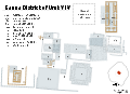
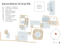
Eanna District
Eanna IVa (light brown) and IVb (dark brown)
The Eanna district is historically significant as both writing and monumental public architecture emerged here during Uruk periods VI–IV. The combination of these two developments places Eanna as arguably the first true city and civilization in human history. Eanna during period IVa contains the earliest examples of writing.[64]
The first building of Eanna, Stone-Cone Temple (Mosaic Temple), was built in period VI over a preexisting Ubaid temple and is enclosed by a limestone wall with an elaborate system of buttresses. The Stone-Cone Temple, named for the mosaic of colored stone cones driven into the adobe brick façade, may be the earliest water cult in Mesopotamia. It was "destroyed by force" in Uruk IVb period and its contents interred in the Riemchen Building.[38]
An Uruk period cylinder-seal and its impression, c. 3100 BC. Louvre.
In the following period, Uruk V, about 100m east of the Stone-Cone Temple the Limestone Temple was built on a 2m high rammed-earth podium over a pre-existing Ubaid temple, which like the Stone-Cone Temple represents a continuation of Ubaid culture. However, the Limestone Temple was unprecedented for its size and use of stone, a clear departure from traditional Ubaid architecture. The stone was quarried from an outcrop at Umayyad about 60km east of Uruk. It is unclear if the entire temple or just the foundation was built of this limestone. The Limestone Temple is probably the first Inanna temple, but it is impossible to know with certainty. Like the Stone-Cone temple the Limestone temple was also covered in cone mosaics. Both of these temples were rectangles with their corners aligned to the cardinal directions, a central hall flanked along the long axis by two smaller halls, and buttressed façades; the prototype of all future Mesopotamian temple architectural typology.
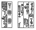
Tablet from Uruk III (c. 3200–3000 BC) recording beer distributions from the storerooms of an institution, British Museum
Between these two monumental structures a complex of buildings (called A–C, E–K, Riemchen, Cone-Mosaic), courts, and walls was built during Eanna IVb. These buildings were built during a time of great expansion in Uruk as the city grew to 250ha (620 acres) and established long-distance trade, and are a continuation of architecture from the previous period. The Riemchen Building, named for the 16cm (6.3in)×16cm (6.3in) brick shape called Riemchen by the Germans, is a memorial with a ritual fire kept burning in the center for the Stone-Cone Temple after it was destroyed. For this reason, Uruk IV period represents a reorientation of belief and culture. The facade of this memorial may have been covered in geometric and figural murals. The Riemchen bricks first used in this temple were used to construct all buildings of Uruk IV period Eanna. The use of colored cones as a façade treatment was greatly developed as well, perhaps used to greatest effect in the Cone-Mosaic Temple. Composed of three parts: Temple N, the Round Pillar Hall, and the Cone-Mosaic Courtyard, this temple was the most monumental structure of Eanna at the time. They were all ritually destroyed and the entire Eanna district was rebuilt in period IVa at an even grander scale.
During Eanna IVa, the Limestone Temple was demolished and the Red Temple built on its foundations. The accumulated debris of the Uruk IVb buildings were formed into a terrace, the L-Shaped Terrace, on which Buildings C, D, M, Great Hall, and Pillar Hall were built. Building E was initially thought to be a palace, but later proven to be a communal building. Also in period IV, the Great Court, a sunken courtyard surrounded by two tiers of benches covered in cone mosaic, was built. A small aqueduct drains into the Great Courtyard, which may have irrigated a garden at one time. The impressive buildings of this period were built as Uruk reached its zenith and expanded to 600hectares. All the buildings of Eanna IVa were destroyed sometime in Uruk III, for unclear reasons.[citation needed]
The architecture of Eanna in period III was very different from what had preceded it. The complex of monumental temples was replaced with baths around the Great Courtyard and the labyrinthine Rammed-Earth Building. This period corresponds to Early Dynastic Sumer c. 2900BC, a time of great social upheaval when the dominance of Uruk was eclipsed by competing city-states. The fortress-like architecture of this time is a reflection of that turmoil. The temple of Inanna continued functioning during this time in a new form and under a new name, 'The House of Inanna in Uruk' (Sumerian: e₂-ᵈinanna unuᵏⁱ-ga). The location of this structure is currently unknown.[7]
The Sumerian King List (SKL) lists only 22 rulers among five dynasties of Uruk. The sixth dynasty was an Amorite dynasty not mentioned on the SKL. The following list should not be considered complete.
Rulers in orange are legendary figures with notably uncertain historicity.
A "governor" of Uruk who overthrew the Gutians and briefly ruled Sumer until he was succeeded by Ur-Nammu, who he had appointed governor of Ur, thus ending the final Sumerian dynasty of Uruk.[73]
Said on the SKL to have held the title of, "King" of not just Uruk; but, to have held the "Kingship" over all of Sumer
Historicity certain
"1 king; he ruled for 7 years, 6 months, and 15 days. Then Uruk was defeated and the kingship was taken to Ur."
12Nissen, Hans J (2003). "Uruk and the formation of the city". In Aruz, J (ed.). Art of the First Cities: The Third Millennium B.C. from the Mediterranean to the Indus. New York: Metropolitan Museum of Art. pp.11–20. ISBN978-0-300-09883-9.
↑Algaze, Guillermo (2013). "The end of prehistory and the Uruk period". In Crawford, Harriet (ed.). The Sumerian World. London: Routledge. pp.68–95. ISBN978-1-138-23863-3.
12William Loftus, "Travels and researches in Chaldæa and Susiana; with an account of excavations at Warka, the Erech of Nimrod, and Shúsh, Shushan the Palace of Esther, in 1849-52", J. Nisbet and Co, 1857
↑Warwick Ball, "Rome in the East: the transformation of an empire", Routledge, 2016
↑Marchesi, Gianni, "The Sumerian King List and the early history of Mesopotamia", Vicino Oriente Quaderno, pp. 231–248, 2010
12Eva von Dassow, "Narām-Sîn of Uruk: A New King in an Old Shoebox", Journal of Cuneiform Studies, vol. 61, pp. 63–91, 2009
12Frayne, Douglas, "Uruk", Old Babylonian Period (2003-1595 B.C.): Early Periods, Volume 4, Toronto: University of Toronto Press, pp. 439–483, 1990
↑Rients de Boer, "Beginnings of Old Babylonian Babylon: Sumu-Abum and Sumu-La-El", Journal of Cuneiform Studies, vol. 70, pp. 53–86, 2018
↑Seri, Andrea, "The archive of the house of prisoners and political history", The House of Prisoners: Slavery and State in Uruk during the Revolt against Samsu-iluna, Berlin, Boston: De Gruyter, pp. 20–54, 2013
↑Witold Tyborowski, "New Tablets from Kisurra and the Chronology of Central Babylonia in the Early Old Babylonian Period", Zeitschrift für Assyriologie und Vorderasiatische Archäologie, vol. 102, iss. 2, pp. 245–269, 2012, ISSN 0084-5299
12H. D. Baker, "The Urban Landscape in First Millennium BC Babylonia", University of Vienna, 2002
↑R. van der Spek "The Latest on Seleucid Empire Building in the East". Journal of the American Oriental Society 138.2 (2018): 385–394.
12R. van der Spek. "Feeding Hellenistic Seleucia on the Tigris". In R. Alston & O. van Nijf, eds. Feeding the Ancient Greek City 36. Leuven ; Dudley, Massachusetts: Peeters Publishers, 2008.
↑C. A. Petrie, "Seleucid Uruk: An Analysis of Ceramic Distribution", Iraq, vol. 64, 2002, pp. 85–123, 2002
↑Rudolf Macuch, "Gefäßinschriften", in Eva Strommenger (ed.), Gefässe aus Uruk von der Neubabylonischen Zeit bis zu den Sasaniden (= Ausgrabungen der deutschen Forschungsgemeinschaft in Uruk-Warka 7), pp. 55–57, pl. 57.1–3, Berlin: Gebr. Mann, 1967
↑Nissen, H. J., "Uruk: Key Site of the Period and Key Site of the Problem", in Artefacts of Complexity: Tracking the Uruk in the Near East, edited by J. N. Postgate, Warminster: British School of Archaeology in Iraq, pp. 1–16, 2002
12Nissen, H. J., "The City Wall of Uruk", in Ucko, P. J., R. Tringham and G. W. Dimbleby (eds.), Man, Settlement and Urbanism. London: Duckworth, pp. 793–98, 1972
↑North, Robert, "Status of the Warka Excavation", Orientalia, vol. 26, no. 3, pp. 185–256, 1957
↑Fraser, James Baillie, "Travels in Koordistan, Mesopotamia, Etc: Including an Account of Parts of Those Countries Hitherto Unvisited by Europeans", R. Bentley, 1840
↑Reade, Julian, "Early monuments in Gulf stone at the British Museum, with observations on some Gudea statues and the location of Agade", vol. 92, no. 2, pp. 258-295, 2002
↑Walter Andrae, "Die deutschen Ausgrabungen in Warka (Uruk)", Berlin, 1935
↑H. J. Lenzen, "New discoveries at Warka in southern Iraq", Archaeology, vol. 17, pp. 122–131, 1964
↑J. Schmidt, "Uruk-Warka, Susammenfassender Bericht uber die 27. Kampagne 1969", Baghdader, vol. 5, pp. 51–96, 1970
↑Rainer Michael Boehmer, "Uruk 1980–1990: a progress report", Antiquity, vol. 65, pp. 465–478, 1991
↑M. van Ess and J. Fassbinder, "Magnetic prospection of Uruk (Warka) Iraq", in: La Prospection Géophysique, Dossiers d'Archeologie Nr. 308, pp. 20–25, Nov. 2005
↑Van Ess, Margarete, and J. Fassbinder, "Uruk-Warka. Archaeological Research 2016–2018, Preliminary Report", Sumer Journal of Archaeology of Iraq 65, pp. 47–85, 2019
↑Fassbinder, Jörg WE, Sandra E. Hahn, and Mandana Parsi, "Archaeological Geophysics in the Marshy Area of Southern Mesopotamia. Insights and Details of Water Management in Uruk-Warka, Ur, and Fara-Šuruppak", Sumer and the Sea: Deltas, Shoreline, and Urban Water Management in 3rd Millennium Mesopotamia. Proceedings of the 1st ARWA International Research Workshop (Rome, 2–4 June 2021), pp. 79-90 , 2025 ISBN978-2-503-61468-7
↑Hans J. Nissen, "The Archaic Texts from Uruk", World Archaeology, vol. 17, no. 3, pp. 317–334, 1986
↑M. W. Green, "Archaic Uruk Cuneiform", American Journal of Archaeology, vol. 90, no. 4, pp. 464–466, 1986
↑Jan J. A. Djik, "Texte aus dem Rēš-Heiligtum in Uruk-Warka", (= Baghdader Mitteilungen. Beiheft 2), Berlin: Gebr. Mann Verlag, 1980 ISBN3-7861-1282-7
↑Egbert von Weiher, "Spätbabylonischen Texte aus Uruk, Teil II". (= Ausgrabungen der Deutschen Forschungsgemeinschaft in Uruk-Warka 10), Berlin: Gebr. Mann Verlag, 1983 ISBN3-7861-1336-X
↑Egbert von Weiher, "Spätbabylonischen Texte aus Uruk, Teil III", (= Ausgrabungen der Deutschen Forschungsgemeinschaft in Uruk-Warka 12), Berlin: Gebr. Mann Verlag, 1988 ISBN3-7861-1508-7
↑Egbert von Weiher, "Uruk. Spätbabylonischen Texte aus aus dem Planquadrat U 18, Teil IV", (= Ausgrabungen in Uruk-Warka. Endberichte 12), Mainz am Rhein: Philipp von Zabern, 1993 ISBN3-8053-1504-X
↑Egbert von Weiher, Uruk. Spätbabylonischen Texte aus aus dem Planquadrat U 18, Teil V (= Ausgrabungen in Uruk-Warka. Endberichte 13), Mainz am Rhein: Philipp von Zabern, 1998 ISBN3-8053-1850-2
↑Erlend Gehlken, "Uruk. Spätbabylonischen Wirtschaftstext aus dem Eanna-Archiv, Teil 1", (= Ausgrabungen in Uruk-Warka. Endberichte 5), Mainz am Rhein: Philipp von Zabern, 1990 ISBN3-8053-1217-2
↑Erlend Gehlken, "Uruk. Spätbabylonischen Wirtschaftstext aus dem Eanna-Archiv, Teil 2", (= Ausgrabungen in Uruk-Warka. Endberichte 11), Mainz am Rhein: Philipp von Zabern, 1996 ISBN3-8053-1545-7
↑Corò, Paola, "The Missing Link – Connections between Administrative and Legal Documents in Hellenistic Uruk", Archiv für Orientforschung, vol. 53, pp. 86–92, 2015
↑Hunger, Hermann and de Jong, Teije, "Almanac W22340a From Uruk: The Latest Datable Cuneiform Tablet", Zeitschrift für Assyriologie und vorderasiatische Archäologie, vol. 104, no. 2, pp. 182–194, 2014
↑Mattessich, Richard, "Recent Insights into Mesopotamian Accounting of the 3rd Millennium B.C — Successor to Token Accounting", The Accounting Historians Journal, vol. 25, no. 1, pp. 1–27, 1998
↑Nissen, HansJörg; Damerow, Peter; Englund, Robert K., Archaic Bookkeeping: Early Writing and Techniques of Economic Administration in the Ancient Near East, Chicago: University of Chicago Press, 1993
↑Burmeister, Stefan (2017). The Interplay of People and Technologies Archaeological Case Studies on Innovations. Bernbeck, Reinhard (1sted.). Berlin. ISBN978-3-9816751-8-4. OCLC987573072.{{cite book}}: CS1 maint: location missing publisher (link)
↑Nissen, Hans J. (2015). "Urbanization and the techniques of communication: the Mesopotamian city of Uruk during the fourth millennium BCE". In Yoffee, Norman (ed.). Early Cities in Comparative Perspective, 4000 BCE–1200 CE. The Cambridge World History. Vol.3. Cambridge University Press. p.113. ISBN978-0-521-19008-4.
↑Steinkeller, Piotr, "A Campaign of Southern City-States against Kiš as Documented in the ED IIIa Sources from Šuruppak (Fara)", Journal of Cuneiform Studies 76.1, pp. 3-26, 2024
↑Jestin, Raymond R. 1937. Tablettes Sumériennes de S̈uruppak Conservées Au Musée de Stamboul. Mémoires de L’institut Français d’Archéologie de Stamboul 3. Paris : E. de Boccard.
R. McC. Adams and H. Nissen, "The Uruk Countryside: The Natural Setting of Urban Societies", Chicago: University of Chicago Press, 1972 ISBN0-226-00500-3
Banks, Edgar James, "A Vase Inscription from Warka", The American Journal of Semitic Languages and Literatures, vol. 21, no. 1, pp.62–63, 1904
Brandes, Mark A., "Untersuchungen zur Komposition der Stiftmosaiken an der Pfeilerhalle der Schicht IVa in Uruk-Warka", Berlin: Gebr. Mann, 1968.
Green, MW (1984). "The Uruk Lament". Journal of the American Oriental Society. 104 (2): 253–279. doi:10.2307/602171. JSTOR602171.
Liverani, Mario; Zainab Bahrani; Marc Van de Mieroop (2006). Uruk: The First City. London: Equinox Publishing. ISBN1-84553-191-4.
Seton Lloyd, "Foundations in the Dust", Oxford University Press, 1947
Nies, James B., "A Pre-Sargonic Inscription on Limestone from Warka", Journal of the American Oriental Society 38, pp.188–196, 1918
Nissen, Hans J., "Uruk and I", Cuneiform Digital Library Journal 2024 (1), 2024
Ann Louise Perkins, "The Comparative Archeology of Early Mesopotamia", Studies in Ancient Oriental Civilization 25, Chicago: The University of Chicago Press, 1949
Postgate, J.N. (1994). Early Mesopotamia, Society and Economy at the Dawn of History. New York, New York: Routledge Publishing. p.367. ISBN0-415-00843-3.
Rositani, Annunziata, "The Status of War Prisoners at Uruk in the Old Babylonian Period", Journal of Ancient Near Eastern History, 2024
Rositani, Annunziata, "King Rīm-Anum of Uruk: A Reconstruction of an Old Babylonian Rebel Kingdom", DOCUMENTA ASIANA 14, pp.109–123, 2024
Rothman, Mitchell S. (2001). Uruk, Mesopotamia & Its Neighbors. Santa Fe: School of American Research Press. p.556. ISBN1-930618-03-4.
Sandowicz, Małgorzata, Cornelia Wunsch, and Stefan Zawadzki, "On Shifting Social and Urban Landscapes in Uruk under Nabû-kudurrī-uṣur II: A View from One Neighborhood", Altorientalische Forschungen 50.2, pp.206–236, 2023
Stevens, Kathryn, "Secrets in the Library: Protected Knowledge and Professional Identity in Late Babylonian Uruk", Iraq, vol. 75, pp.211–53, 2013
Eva Strommenger, The Chronological Division of the Archaic Levels of Uruk-Eanna VI to III/II: Past and Present, American Journal of Archaeology, vol. 84, no. 4, pp.479–487, Oct. 1980
Szarzyńska, Krystyna, "Offerings for the Goddess Inana in Archaic Uruk", Revue d'Assyriologie et d'archéologie Orientale, vol. 87, no. 1, pp.7–28, 1993
Krystyna Szarzyńska, Observations on the Temple Precinct EŠ3 in Archaic Uruk, Journal of Cuneiform Sudies, vol. 63, pp.1–4, 2011
This page is based on this Wikipedia article Text is available under the CC BY-SA 4.0 license; additional terms may apply. Images, videos and audio are available under their respective licenses.