Arad or ARAD may refer to:

In archaeology a tell or tel is an artificial topographical feature, a mound consisting of the accumulated and stratified debris of a succession of consecutive settlements at the same site, the refuse of generations of people who built and inhabited them and natural sediment.
Umm el-Marra,, east of modern Aleppo in the Jabbul Plain of northern Syria, was one of the ancient Near East's oldest cities, located on a crossroads of two trade routes northwest of Ebla, in a landscape that was much more fertile than it is today. Possibly this is the city of Tuba mentioned in Egyptian inscriptions listing cities that were defeated or destroyed in the Pharaoh Thutmose III's north Syrian campaign. The city of Tuba is also mentioned in epigraphic remains from Ebla, Mari, and Alalakh.

Dur-Kurigalzu was a city in southern Mesopotamia, near the confluence of the Tigris and Diyala rivers, about 30 kilometres (19 mi) west of the center of Baghdad. It was founded by a Kassite king of Babylon, Kurigalzu I and was abandoned after the fall of the Kassite dynasty. The city was of such importance that it appeared on toponym lists in the funerary temple of the Egyptian pharaoh, Amenophis III at Kom el-Hettan". The prefix Dur is an Akkadian term meaning "fortress of", while the Kassite royal name Kurigalzu is believed to have meant "shepherd of the Kassites". The tradition of naming new towns Dur dates back to the Old Babylonian period with an example being Dūr-Ammī-ditāna. The city contained a ziggurat and temples dedicated to Mesopotamian gods, as well as a royal palace which covered 420,000 square meters.

LMLK seals are ancient Hebrew seals stamped on the handles of large storage jars first issued in the reign of King Hezekiah and discovered mostly in and around Jerusalem. Several complete jars were found in situ buried under a destruction layer caused by Sennacherib at Lachish. While none of the original seals have been found, some 2,000 impressions made by at least 21 seal types have been published. The iconography of the two and four winged symbols are representative of royal symbols whose meaning "was tailored in each kingdom to the local religion and ideology".

Anshan modern Tall-e Malyan, also Tall-i Malyan, was an Elamite and ancient Persian city. It was located in the Zagros Mountains in southwestern Iran, approximately 46 kilometres (29 mi) north of Shiraz and 43 kilometres (27 mi) west of Persepolis in the Beyza/Ramjerd plain, in the province of Fars.

The Yarmuk River is the largest tributary of the Jordan River. It runs in Jordan, Syria and Israel, and drains much of the Hauran plateau. Its main tributaries are the wadis of 'Allan and Ruqqad from the north, Ehreir and Zeizun from the east. Although the Yarmuk is narrow and shallow throughout its course, at its mouth it is nearly as wide as the Jordan, measuring thirty feet in breadth and five in depth. The once celebrated Matthew Bridge used to cross the Yarmuk at its confluence with the Jordan.
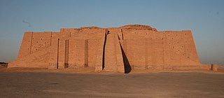
The Zigguratof Ur is a Neo-Sumerian ziggurat in what was the city of Ur near Nasiriyah, in present-day Dhi Qar Province, Iraq. The structure was built during the Early Bronze Age but had crumbled to ruins by the 6th century BC of the Neo-Babylonian period, when it was restored by King Nabonidus.

Sam'al, is an archaeological site located in the Anti-Taurus Mountains of modern Turkey's Gaziantep Province. During its time under the control of the Neo-Assyrian Empire it was called, by them, Sam'al. It was founded at least as far back as the Early Bronze Age and thrived between 3000 and 2000 BC, and on the highest part of the upper mound was found a walled citadel of the Middle Bronze Age. New excavations revealed a monumental complex in the Middle Bronze Age II, and another structure that was destroyed in the mid to late 17th century BC, maybe by Hititte king Hattusili I. This event was recently radiocarbon-dated to sometime between 1632 and 1610 BC, during the late Middle Bronze Age II. The site was thought to have been abandoned during the Hittite and Mitanni periods, but excavations in 2021 season showed evidence of occupation during the Late Bronze Age in Hittite times. It flourished again in the Iron Age, initially under Luwian-speaking Neo-Hittites, and by 920 B.C. had become a kingdom. In the 9th and 8th century BC it came under control of the Neo-Assyrian Empire and by the 7th century BC had become a directly ruled Assyrian province.

Akshak was a city of ancient Sumer, situated on the northern boundary of Akkad, sometimes identified with Babylonian Upi. It is known, based on an inscription "‘Ur-kisala, the sangu-priest of Sin of Akshak, son of Na-ti, pasisu-priest of Sin to Salam presented [this statue]." that there was a temple of the god Sin in Akshak.
Tell Ashtara is an archaeological mound south of Damascus. The Bronze Age city that once stood here may have been mentioned in the Amarna letters correspondence of 1350 BC as Aštartu, and is usually identified with the Biblical city of Ashtaroth.
Khirbet Kerak or Beth Yerah is a tell located on the southern shore of the Sea of Galilee in modern-day Israel. The tell spans an area of over 50 acres—one of the largest in the Levant—and contains remains dating from the Early Bronze Age and from the Persian period through to the Early Islamic period.

Farwana, was a Palestinian village, located 4.5 kilometers (2.8 mi) south of Bisan, depopulated in 1948.
Umm Al Nar is a Bronze Age culture that existed around 2600-2000 BCE in the area of the modern-day United Arab Emirates and Northern Oman. The etymology derives from the island of the same name which lies adjacent to the city of Abu Dhabi, the capital of the UAE, which provided early evidence and finds that came to define the period.

The Tulul adh-Dhahab is an archaeological site in Jordan. The site features two neighboring tells, separated by the Zarqa River, an affluent of the Jordan River. The two tells are commonly identified with the ancient Israelite cities of Mahanaim and Penuel, mentioned in the Hebrew Bible.

Tell Abraq was an ancient Near Eastern city. Located on the border between Sharjah and Umm Al Quwain in the United Arab Emirates about 50 kilometers north-east of Dubai, the city was originally on the coastline of the Persian Gulf but changing sea levels have placed the remains of the city inland. It is located on the main road from Umm Al Quwain to Falaj Al Mualla.

Tel Yokneam, also spelled Yoqne'am or Jokneam, is an archaeological site located in the northern part of the modern city of Yokneam Illit, Israel. It was known in Arabic by a variant name, Tell Qamun, believed to be a corruption of the Hebrew name. The site is an elevated mound, or tel, spanning around 40 dunams and rising steeply to a height of 60 meters (200 ft). With a few brief interruptions, Yokneam was occupied for 4,000 years, from the Middle Bronze Age to the Ottoman Empire.