Utah State Route 95

Last updated

Utah 95.svg

State Route 95

Bicentennial Highway
Utah State Route 95
Route information
Maintained by UDOT
Length121.351 mi [1]  (195.296 km)
Existed1935–present
Major junctions
West endUtah 24.svg SR-24 in Hanksville
Major intersectionsUtah 276.svg SR-276 twice near Lake Powell
Utah 275.svg SR-275 near Natural Bridges National Monument
Utah 261.svg SR-261 near Abajo Mountains
East endUS 191.svg US 191 south of Blanding
Location
Country United States
State Utah
Highway system
  • Utah State Highway System
Utah 94.svg SR-94 Utah 96.svg SR-96

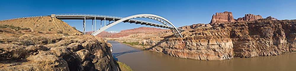
State Route 95 or Bicentennial Highway is a state highway located in the southeast of the U.S. state of Utah. The highway is an access road for tourism in the Lake Powell and Cedar Mesa areas, notably bisecting Bears Ears National Monument and providing the only access to Natural Bridges National Monument. The highway does not serve any cities, but the small town of Hanksville is its western terminus. Although the highway has existed since the 1930s as a primitive dirt road, it received its name at its dedication as a paved state highway coincident with the U.S. Bicentennial in 1976. The highway forms part of the Trail of the Ancients National Scenic Byway.

Contents

Hite Crossing Bridge and Colorado River Hite Crossing Bridge, Glen Canyon.jpg
Hite Crossing Bridge and Colorado River

Route description

SR-95 approaching SR-276 Utah State Routes 95 and 276.jpg
SR-95 approaching SR-276

It runs 121 miles (195 km) west from the junction of U.S. Route 191 (4.3 miles south of the town of Blanding), to the junction of SR-24 in the town of Hanksville. It crosses Cottonwood Wash just west of the US-191 junction; follows and crosses White Canyon; and crosses the Colorado River and the northeast end of Lake Powell at Hite Crossing Bridge, near the confluence of the Dirty Devil River, which it crosses just two miles (3 km) later.

29 miles (47 km) west of the US-191 junction it meets State Route 261 on Cedar Mesa, 2 miles (3.2 km) west of there State Route 275 spurs off to the northwest to Natural Bridges National Monument, and it intersects with State Route 276 twice, on either side of Lake Powell.

It passes by the now closed Fry Canyon Lodge in Fry Canyon, which opened in 1955 and closed in 2007. Fry's Canyon (also referred to as Fry's Gulch) contained the only gas station between Hanksville and Blanding, but it has since closed and there are no services on the route itself. A seasonal gas station is in operation at the Hite Marina area during the summer months.

History

Vista along SR-95 Highway 95.JPG
Vista along SR-95

SR-95 was added to the state highway system in 1935 as a spur connecting SR-47 (now US-191) near Blanding with Natural Bridges National Monument. [2] It was extended in 1949, crossing the Colorado River at Hite and continuing to SR-24 at Hanksville. [3] Except for a short piece near Blanding, the road remained unpaved through the 1960s. [4] The first major realignment was approved in 1962 and completed in 1966, [5] bypassing the old crossing at Hite, which is now flooded by Lake Powell, in favor of the new Hite Crossing Bridge. [6] The highway was improved and paved in time for the U.S. Bicentennial in 1976, and has since been known as the Bicentennial Highway. [7]

Hite Crossing Bridge HWY95 view2 MC.jpg
The Hite Crossing Bridge spanning the Colorado River

Major intersections

CountyLocation [8] mi [1] kmDestinationsNotes
Wayne Hanksville 00.0Utah 24.svg SR-24  Green River, Torrey
Garfield 26.07641.965Utah 276.svg SR-276  Lake Powell
33.323153.6283Hog Springs Rest Area
Glen Canyon National
Recreation Area
41.17666.266Hite Overlook View Area
43.17969.490Information Area
43.82370.526Campgrounds
San Juan 52.90785.146 Lake Powell
56.71491.272View Area
83.517134.408Utah 276.svg SR-276  Lake PowellBullfrog Marina
91.137146.671Utah 275.svg SR-275  Natural Bridges National Monument
92.931149.558Utah 261.svg SR-261  Mexican Hat, Bluff, Cedar Mesa, Moki Dugway
96.995156.098Salvation Knoll View Area
101.425163.228Indian Ruins
107.170172.473Arch Canyon Campgrounds
110.768178.264Indian Ruins
115.001185.076 Manti-La Sal National Forest Access
121.351195.296US 191.svg US 191  Blanding, Bluff
1.000 mi = 1.609 km; 1.000 km = 0.621 mi

Related Research Articles

<span class="mw-page-title-main">Dirty Devil River</span> River in Utah, United States

The Dirty Devil River is an 80-mile-long (130 km) tributary of the Colorado River, located in the U.S. state of Utah. It flows through southern Utah from the confluence of the Fremont River and Muddy Creek before emptying into the Colorado River at Lake Powell.

<span class="mw-page-title-main">U.S. Route 163</span> Highway in Arizona and Utah

U.S. Route 163 is a 64-mile (103 km) U.S. Highway that runs from US 160 northward to US 191 in the U.S. states of Arizona and Utah. The southernmost 44 miles (71 km) of its length are within the Navajo Nation. The highway forms part of the Trail of the Ancients, a National Scenic Byway. The highway cuts through the heart of Monument Valley and has been featured in numerous movies and commercials.

<span class="mw-page-title-main">U.S. Route 189</span> Highway in the United States

U.S. Route 189 is a spur of U.S. Route 89. It currently runs for 322 miles (518 km) from Provo, Utah at Interstate 15 to Jackson, Wyoming. The highway was not part of the original 1926 U.S. Highway system. The highway was created in the 1930s, absorbing former U.S. Route 530 and a portion of U.S. Route 30S. The portion through Provo Canyon has been designated the Provo Canyon Scenic Byway by the state of Utah.

<span class="mw-page-title-main">U.S. Route 89</span> Highway in the United States

U.S. Route 89 is a north–south United States Numbered Highway with two sections, and one former section. The southern section runs for 848 miles (1,365 km) from Flagstaff, Arizona, to the southern entrance of Yellowstone National Park. The northern section runs for 404 miles (650 km) from the northern entrance of Yellowstone National Park in Montana, ending at the Canadian border. Unnumbered roads through Yellowstone connect the two sections. Before 1992, US 89 was a Canada–Mexico, border-to-border highway that ended at Nogales, Arizona, on its southern end.

<span class="mw-page-title-main">U.S. Route 191</span> Numbered Highway in the United States

U.S. Route 191 is a spur of U.S. Route 91 that has two segments. The southern segment runs for 1,102 miles (1,773 km) from Douglas, Arizona on the Mexican border to the southern part of Yellowstone National Park. The northern segment runs for 442 miles (711 km) from the northern part of Yellowstone National Park to Loring, Montana, at the Canada–US border. Unnumbered roads within Yellowstone National Park connect the two segments. The highway passes through the states of Arizona, Utah, Wyoming, and Montana.

<span class="mw-page-title-main">Utah State Route 12</span> State highway in Garfield and Wayne counties in Utah, United States

State Route 12 or Scenic Byway 12 (SR-12), also known as "Highway 12 — A Journey Through Time Scenic Byway", is a 123-mile-long (198 km) state highway designated an All-American Road located in Garfield County and Wayne County, Utah, United States.

<span class="mw-page-title-main">Utah State Route 261</span> State highway in Utah, United States

State Route 261 is a state highway located entirely within south-central San Juan County, Utah. It runs 34 miles (55 km) north, from the junction of U.S. Route 163, to the junction with State Route 95, just east of Natural Bridges National Monument.

<span class="mw-page-title-main">Fry Canyon, Utah</span> Ghost town in Utah, United States

Fry Canyon was a small community in San Juan County, Utah, United States, located in Fry Canyon, just south of White Canyon, 50 miles (80 km) west on State Route 95 from its junction with U.S. Route 191 at Blanding.

<span class="mw-page-title-main">Utah State Route 275</span> State highway in Utah, United States

State Route 275 is a state highway located entirely within central San Juan County, Utah, United States, on the northwestern limits of Cedar Mesa. The highway provides access to the Bears Ears and Natural Bridges National Monument.

<span class="mw-page-title-main">Utah State Route 276</span> State highway in Utah, United States

State Route 276 is a state highway in remote portions of San Juan County, eastern Garfield County, and Kane County, in the southeast of the U.S. state of Utah. The route is used as an access to Lake Powell, serving the small resort towns of Ticaboo and Bullfrog. Historically, SR-276 crossed Lake Powell via the Charles Hall Ferry, the only auto ferry in the state of Utah; however, the ferry is currently out of service due to low water levels. The entire route is part of the Trail of the Ancients National Scenic Byway. Lake Powell separates the route into two sections; the eastern section was numbered State Route 263 prior to the existence of the ferry.

<span class="mw-page-title-main">Utah State Route 128</span> State highway in Grand County, Utah, United States

State Route 128 (SR-128) is a 44.564-mile-long (71.719 km) state highway in the U.S. state of Utah. The entire length of the highway has been designated the Upper Colorado River Scenic Byway, as part of the Utah Scenic Byways program. This road also forms part of the Dinosaur Diamond Prehistoric Highway, a National Scenic Byway. Residents of Moab frequently refer to SR-128 as "the river road", after the Colorado River, which the highway follows.

<span class="mw-page-title-main">U.S. Route 160 in Arizona</span> US Highway section within the state of Arizona

U.S. Route 160 (US 160), also known as the Navajo Trail, is a U.S. Highway which travels west to east across the Navajo Nation and Northeast Arizona for 159.35 miles (256.45 km). US 160 begins at a junction with US 89 north of Cameron and exits the state into New Mexico south of the Four Corners Monument. Along its journey, the route connects the communities of Tuba City, Moenkopi, Rare Metals, Tonalea, Tsegi, Kayenta, Dennehotso, Mexican Water, Red Mesa, and Teec Nos Pos.

<span class="mw-page-title-main">Utah State Route 20</span> State highway in Iron and Garfield counties in Utah, United States

State Route 20 (SR-20) is a state highway in southern Utah, running 20.492 miles (32.979 km) in Iron and Garfield Counties, without directly serving or connecting any cities. It serves as a truck connection between I-15 and US-89 and an access to Bryce Canyon National Park. It may also be used to travel between Salt Lake City and Phoenix, Arizona. The highway follows the route of the Old Spanish Trail.

<span class="mw-page-title-main">U.S. Route 89 in Utah</span> Section of U.S. Highway in Utah, United States

U.S. Route 89 in the U.S. state of Utah is a north-south United States Highway spanning more than 502 miles (807.891 km) through the central part of the state, making it the longest road in Utah. Between Provo and Brigham City, US-89 serves as a local road, paralleling Interstate 15, but the portions from Arizona north to Provo and Brigham City northeast to Wyoming serve separate corridors. The former provides access to several national parks and Arizona, and the latter connects I-15 with Logan, the state's only Metropolitan Statistical Area not on the Interstate.

<span class="mw-page-title-main">U.S. Route 191 in Utah</span> Section of U.S. Highway in Utah, United States

U.S. Route 191 (US-191) is a major 404.168-mile (650.445 km), north–south U.S. Numbered Highway through eastern Utah, United States. The present alignment of US-191, which stretches from Mexico to Canada, was created in 1981 through Utah. Previously the route had entered northern Utah, ending at US-91 in Brigham City, but with the completion of I-15 it was truncated to Yellowstone National Park and re-extended on a completely different alignment. In addition to a large portion of US-163, this extension absorbed several state routes: SR-33, most of SR-44, and SR-260.

<span class="mw-page-title-main">Dinosaur Diamond</span> Scenic road in Utah and Colorado in the United States

The Dinosaur Diamond is a 486-mile (782 km) scenic and historic byway loop through the dinosaur fossil laden Uinta Basin of the U.S. states of Utah and Colorado. The byway comprises the following two National Scenic Byways:

<span class="mw-page-title-main">U.S. Route 6 in Utah</span> Section of U.S. Highway in Utah

U.S. Route 6 (US-6) is an east–west United States Numbered Highway through the central part of the U.S. state of Utah. Although it is only about 40 miles (64 km) longer than US-50, it serves more populated areas and, in fact, follows what had been US-50's routing until it was moved to follow Interstate 70 (I-70) in 1976. In 2009, the Utah State Legislature named part of the route the "Mike Dmitrich Highway", named after the Utah state senator, which generated controversy, as the state of Utah had previously joined with all the other states through which US-6 passes in naming all of US-6 the Grand Army of the Republic Highway.

<span class="mw-page-title-main">Utah State Route 73</span> State highway in Utah, United States

State Route 73 (SR-73) is a 36.147-mile-long (58.173 km) state highway in the U.S. state of Utah, connecting the Rush, Cedar, and Utah Valleys. It is a discontinuous route in two segments; one long segment connecting SR-36 to Saratoga Springs, and one short segment within the city of Lehi.

<span class="mw-page-title-main">Hite Crossing Bridge</span> Bridge in Utah, US

The Hite Crossing Bridge is an arch bridge that carries Utah State Route 95 across the Colorado River northwest of Blanding, Utah, United States. The bridge informally marks the upstream limit of Lake Powell and the end of Cataract Canyon of the Colorado River, but when the lake is at normal water elevation, the water can back up over 30 miles (48 km) upstream into Cataract Canyon. The bridge is the only automobile bridge spanning the Colorado River between the Glen Canyon Bridge, 185 miles (298 km) downstream near the Glen Canyon Dam and the U.S. Route 191 bridge 110 miles (180 km) upstream near Moab. The bridge is near Hite Marina on Lake Powell, and a small airstrip is immediately adjacent to the north side of the bridge.

<span class="mw-page-title-main">Trail of the Ancients</span> National Scenic Byways in Arizona, Colorado, New Mexico, and Utah, United States

The Trail of the Ancients is a collection of National Scenic Byways located in the U.S. Four Corners states of Utah, Colorado, New Mexico, and Arizona. These byways comprise:

References

  1. 1 2 "Highway Descriptions - Route 0095". Utah Department of Transportation.
  2. Utah State Legislature (1935). "Chapter 37: Designation of State Roads". Session Laws of Utah. Route 95. From Blanding westerly to Natural Bridges National Monument.
  3. Utah State Legislature (1949). "Chapter 48: Designation of State Roads". Session Laws of Utah. Route 95. From Blanding on route 47 westerly via Natural Bridges National Monument to Hite; thence northerly to route 24 at Hanksville.
  4. H.M. Gousha Company, Road Atlas, 1967
  5. Jack Goodman, New York Times, Unnatural Arches; Utah to Dedicate 3 Man-Made Spans In Natural Bridges Area on Friday, May 29, 1966, p. XX17
  6. Utah Department of Transportation, Highway Resolutions: "Route 95". (6.99 MB), updated November 2007, accessed May 2008
  7. "Bicentennial Highway". U.S. Department of Transportation. Archived from the original on 2010-04-09. Retrieved 2007-10-24.
  8. Utah Road and Recreation Atlas (Map). 1:170000. Benchmark Maps. 2002. p. 88–91. ISBN   0-929591-74-7.
Template:Attached KML/Utah State Route 95
KML is not from Wikidata