
Chisana is a ghost town abandoned and a census-designated place (CDP) in the Copper River Census Area in the U.S. state of Alaska. As of the 2010 Census, the population of the CDP was 0. The English name Chisana derives from the Ahtna Athabascan name Tsetsaan' Na, meaning literally 'copper river'. The Chisana River joins the Nabesna River just north of Northway Junction, Alaska, to form the Tanana River, a major tributary of the Yukon River. The Chisana Airport consists of a turf and gravel runway which is largely serviced by flights from Tok, Alaska.
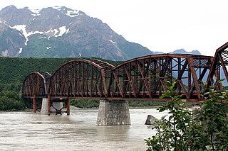
The Miles Glacier Bridge, also known as the Million Dollar Bridge, was built in the early 1900s across the Copper River fifty miles from Cordova in what is now the U.S. state of Alaska. It is a multiple-span Pennsylvania truss bridge which completed a 196-mile (315 km) railroad line for the Copper River and Northwestern Railway, built by J. P. Morgan and the Guggenheim family to haul copper from the old mining town of Kennicott, now located within the Wrangell–St. Elias National Park and Preserve, to the port of Cordova. It earned its nickname because of its $1.4 million cost, well recouped by the about $200 million worth of copper ore which was shipped as a result of its construction.
The Richardson Highway is a highway in the U.S. state of Alaska, running 368 miles (562 km) and connecting Valdez to Fairbanks. It is marked as Alaska Route 4 from Valdez to Delta Junction and as Alaska Route 2 from there to Fairbanks. It also connects segments of Alaska Route 1 between the Glenn Highway and the Tok Cut-Off. The Richardson Highway was the first major road built in Alaska.

Kennecott, also known as Kennicott and Kennecott Mines, is an abandoned mining camp in the Valdez-Cordova Census Area in the U.S. state of Alaska that was the center of activity for several copper mines. It is located beside the Kennicott Glacier, northeast of Valdez, inside Wrangell-St. Elias National Park and Preserve. The camp and mines are now a National Historic Landmark District administered by the National Park Service.

The Copper River and Northwestern Railway (CR&NW) consisted of two rail lines, the Copper River line and the Northwestern line. Michael James Heney had secured the right-of-way up the Copper River in 1904. He started building the railway from Cordova, Alaska in 1906. The town of Cordova, Alaska, was actually named by Heney on March 13, 1906, based on the original name given by Salvador Fidalgo. Both these railroads were abandoned and little remains of them. Only a 0-4-0 locomotive, "Ole", located near Goose City on a siding of the Alaska Anthracite Railroad Company is the only equipment left. Many of the holdings of the CR&NW railroad including Ole were acquired for this railroad by Mr. Clark Davis and his partners in 1908 after a major storm destroyed the Katalla area facilities in 1907. The town of Cordova would like to move Ole to a memorial site in Cordova to celebrate its role in these railroads. Ole was declared eligible for the National Register of Historic Places in 1988.
This is a list of properties and districts listed on the National Register of Historic Places in Alaska. There are approximately 400 listed sites in Alaska. Each of the state's 28 boroughs and census areas has at least two listings on the National Register, except for the Kusilvak Census Area, which has none.

The Hole in the Rock Trail is a historic trail running east-southeast from the town of Escalante in southern Utah in the western United States. The Mormon trailblazers who established this trail crossed the Colorado River and ended their journey in the town of Bluff. The Hole-in-the-Rock expedition established the trail in 1879. The trail is located within the borders of the Grand Staircase-Escalante National Monument, the adjacent Glen Canyon National Recreation Area and federal Bureau of Land Management (BLM) public land to the east of the Colorado River. A geologic feature called the Hole in the Rock gave the trail its name. A modern unpaved road called the Hole-in-the-Rock Road closely follows this historic trail to the point where it enters the Glen Canyon National Recreation Area. The modern road is an important access route for visiting the Canyons of the Escalante and the Devils Garden. The trail is listed on the National Register of Historic Places, being added to that list in 1982.

Fort Abercrombie State Historical Park, also known as the Fort Abercrombie State Historic Site, is an Alaska state park on Kodiak Island, Alaska. It includes 182 acres (74 ha) of land at the end of Miller Point, located on the eastern shore of Kodiak Island northeast of the city of Kodiak. The park, established in 1969, is noted for its historical World War II fortifications and its scenery, which includes bluffs overlooking the ocean, spruce forests, and meadows. The site was named in honor of the early Alaska explorer and United States Army officer Lt. Col. William R. Abercrombie. The fortifications, whose surviving elements include gun emplacements, underground magazines, and foundational remnants of buildings, were built in 1941 and abandoned after the war ended, having seen no action.

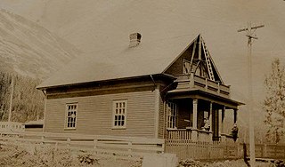
The Sourdough Lodge was built in Alaska between 1903 and 1905 of logs. It was one of a number of roadhouses built along the Valdez Trail. The roadhouses were about 15 miles (24 km) apart and offered shelter for travelers and road construction crews. It was designated a National Historic Landmark on June 2, 1978 as it was the oldest continuously-operating roadhouse in Alaska.

Nabesna is a census-designated place and unincorporated community in northern Valdez-Cordova Census Area, Alaska, United States, in the northern part of the Wrangell-St. Elias National Park and Preserve. It lies along the Nabesna Road, a gravel road that connects it to the Tok Cut-Off at Slana. Its elevation is 2,979 feet (908 m). Founded by and named for the Nabesna Mining Company, the community received a post office in 1909. Located at the base of White Mountain in the Wrangell Mountains, it lies west of the Nabesna River. According to the 2010 Census, there were five people residing at this location.

The Bremner Historic Mining District is a historic district in Wrangell-St. Elias National Park and Preserve in Alaska. It is named after John Bremner, who in 1884-1885 was the first non-native person to live in the area and who prospected for gold along the Bremner River. Located just to the north of the Bremner River, it was the scene of an important placer gold discovery in 1902, and played a key role in the history of the Copper River Basin. Only a few miners struck it rich, but the resulting demand for materials and supplies helped establish regional transportation networks, encouraged supporting industries, and hastened the exploration and settlement of the entire region. While small-scale placer mining continued for over forty years, lode development was largely confined to the period between 1934 and 1941, the district's most significant era.

This is a list of the National Register of Historic Places listings in Valdez–Cordova Census Area, Alaska.
Rika's Landing Roadhouse, also known as Rika's Landing Site or the McCarty Roadhouse, is a roadhouse located at a historically important crossing of the Tanana River, in the Southeast Fairbanks Area, Alaska, United States. It is off mile 274.5 of the Richardson Highway in Big Delta.
The Government Cable Office in Seward, Alaska, United States, is a historic building that served as a telegraph office that connected Seward with communications in the rest of the United States.

The Slana Roadhouse, on Nabesna Road in Slana, Alaska, in the Valdez-Cordova Census Area, is a historic site dating to 1928. The site was listed on the National Register of Historic Places in 2005. The listing included four contributing buildings on 5 acres (2.0 ha).
The Chilkat Oil Company Refinery Site is a historic industrial site near the ghost town of Katalla, Alaska. It is located at the head of Katalla Slough, an arm of Katalla Bay, and about 20 miles (32 km) southeast of the mouth of the Copper River. The site consists of the ruined remnants of Alaska's first petroleum refinery, which operated from roughly 1911 until 1933, when it was partially destroyed by fire and abandoned. Oil had been discovered in Katalla Bay as early as 1902, and the company was formed to exploit the resource, reportedly producing more than 50,000 gallons of gasoline in 1921. Facilities at the site included a warehouse, tank house, running house, coal house, condensing house, and residence, all of which were reported to be in ruins in 1972.
The Copper River and Northwestern Railway Bunkhouse and Messhouse are historic railroad worker facilities on Third Street in Chitina, Alaska. The messhouse is a single-story wood frame structure with a hip roof, measuring 26 by 30 feet. It has a porch on the east side, and a timber-braced entrance on the west side leading to a root cellar under the building. The bunkhouse is also a single-story structure, measuring 43 by 25 feet. It has an enclosed porch on its southern facade, and is divide internally into two large chambers. These facilities were built in 1910 by the Copper River and Northwestern Railway to house its work crews, a service they performed until the railroad shut down in 1938. They are the only surviving elements of what was once a larger CR&NW presence in the community. The buildings are now hosting the Chitina House bed and breakfast.
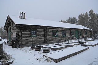
The Gakona Roadhouse is a historic traveler service facility in Gakona, Alaska, at mile 205 of the Glenn Highway. It is a 1-1/2 log structure with a gabled roof covered in corrugated metal. A shed-roof addition extends to the main block's east side. The roadhouse was built c. 1904, during the construction by the United States Army of the Trans-Alaska Military Road between Valdez and Eagle. This roadhouse was strategically located at a place where that road diverged from the old Eagle Trail, used by miners to reach the gold rush fields of the Yukon River. The original 1904 structure is used for storage; the present roadhouse facilities are provided by later (1920s) structures.
The McCarthy Power Plant, also known as the Mother Lode Coalition Mining Company Power House and the Mother Lode Plant, is a historic power plant building in the small community of McCarthy, Alaska, in the heart of Wrangell-St. Elias National Park and Preserve. It is a three-story wood frame structure with a clerestory roof, located on the banks of McCarthy Creek. It was built in 1917, after the arrival of the Copper River and Northwestern Railway in the area kicked of a building boom. The coal-fired power plant was built to provide electricity for the operation of a tramway and other facilities of the Kennecott mines. Most of the transmission lines and the tramway were destroyed by avalanches in 1919, and other changes made soon afterward made the power plant unnecessary, and its turbine was moved up to Kennecott.
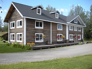
The Sullivan Roadhouse is a restored historic traveler's accommodation, operated as a museum in Delta Junction, Alaska. The roadhouse was added to the National Register of Historic Places in 1979.

