Route 12 is a state highway located in Hunterdon County, New Jersey, United States. It runs 11.69 mi (18.81 km) from the Uhlerstown–Frenchtown Bridge at the Delaware River border with Pennsylvania in Frenchtown east to an intersection with U.S. Route 202 and Route 31 at the Flemington Circle in Flemington. The route is mostly a two-lane undivided road that passes through rural areas of woodland and farmland. It intersects Route 29 and County Route 513 in Frenchtown, CR 519 in Kingwood Township, CR 579 on the border of Delaware Township and Raritan Township, and CR 523 in Raritan Township.
East Amwell Township is a township in Hunterdon County, New Jersey, United States. As of the 2010 United States Census, the township's population was 4,013, reflecting a decline of 442 (-9.9%) from the 4,455 counted in the 2000 Census, which had in turn increased by 123 (+2.8%) from the 4,332 counted in the 1990 Census.

Raven Rock is an unincorporated community and hamlet along the Delaware River approximately three miles (4.8 km) north of Stockton along New Jersey Route 29. The hamlet was known earlier as Saxtonville. It is located within Delaware Township in Hunterdon County, New Jersey, United States. It is the site of Bull's Island Recreation Area. The rock outcrop for which it is named is the southwest corner of the Hunterdon Plateau.

The Amwell Valley is a small valley in Hunterdon County, New Jersey, between the Hunterdon Plateau and the Sourlands. It comprises Stockton, parts of Delaware Township, West Amwell, East Amwell, Flemington and Raritan Township. The region borders the Delaware River to the west and the South Branch Raritan River to the east. The entire area has elevations around two-hundred feet above sea level. US 202 is the main route running west to east through the valley. Old York Road also passes through the valley, taking a generally more southern route through Raritan and along the Sourlands at Mount Airy. Like the Hunterdon Plateau, Amwell Valley still has a large number of farms due to its sufficient climate, relatively flat land and the presence of silt-loams soils. The valley is home to Unionville Winery and Old York Cellars in Ringoes.

The Sourlands is a region in the US state of New Jersey that includes portions of Hunterdon County, Mercer County and Somerset County. It is centered on Sourland Mountain and comprises parts of Lambertville, East Amwell, West Amwell, Hillsborough, Hopewell Boro, Hopewell Township, and Montgomery. The region is flanked by the Hopewell Fault to the south and Amwell Valley to the north that runs from Mount Airy to an area just west of Flagtown and a diabase formation running from Lambertville to Mount Airy. The Sourland also include a hilly area towards the southwest called Pleasant Valley, with a number of farms. Although much of the Sourlands is not conducive to farming, Pleasant Valley and the slopes on the surrounding ridges have a number of farms. The slopes of the ridge to the north are also home to Unionville Vineyard.

Allens Corner is an unincorporated community located within Franklin Township in Hunterdon County, New Jersey, United States.
Croton is an unincorporated community located along the border of Delaware and Raritan townships in Hunterdon County, New Jersey, United States. County Route 579 is the main north–south road through the area which consists of mostly forest within the Hunterdon Plateau and some houses and businesses along Route 579 and nearby New Jersey Route 12. The headwaters of the Wickecheoke Creek are located northeast of Croton before it heads downstream through the community on its way to the Delaware River.

Furmans Corner is an unincorporated community located within East Amwell Township in Hunterdon County, New Jersey, United States. The area is very sparsely populated with only a few homes located along the two roads in the area, Wertsville Road and North Hill Road. The remainder of the area consists of the Union Cemetery of Wertsville and farmland.

Idell is an unincorporated community located within Kingwood Township in Hunterdon County, New Jersey, United States. The community is located at the crossing of Byram-Kingwood Road over the Lockatong Creek. The area is very rural and consists of small farms, houses, and forest land.
Larisons Corners is an unincorporated community located along the border of East Amwell and Raritan townships in Hunterdon County, New Jersey, United States. Its location is at the corner of Old York Road and where New Jersey Route 30 split from Old York Road and headed north towards Flemington. Today, Old York Road is a part of Route 179 to the southwest and County Route 514/Amwell Road northeast of the point. U.S. Route 202 and Route 31 comprise the main road to Flemington though the highway was built on a new alignment to the south of this point after US 202 bypassed Ringoes in the 1960s. A gas station and some small businesses line US 202 in the area and some churches, Larison's Corner Cemetery, and houses make up the remainder of the area.
Scrappy Corner is an unincorporated community located along the border of Lebanon Township in Hunterdon County and Washington Township in Morris County, New Jersey, United States.

Snydertown is an unincorporated community located within East Amwell Township in Hunterdon County, New Jersey, United States. The settlement is located on the southern face of Sourland Mountain at the intersection of Linvale Road and Snydertown Road. In the past, a mill operated in Snydertown.

Sandy Ridge is an unincorporated community located within Delaware Township in Hunterdon County, New Jersey, United States. As its name implies, the community is located at the top of a small hill that is sandwiched between the Hunterdon Plateau and the Sourland Mountains. Sandy Ridge Road is the main road east and west through the community while County Route 605 is a minor arterial road that passes north and south through the area. CR 605 enters from the south on Sandy Ridge-Mt. Airy Road, jogs to the west on Sandy Ridge Road for 0.04 miles (64 m), and exits to the north on Cemetery Road towards CR 523. The area consists of mainly residences with some farmland and forestland. The Sandy Ridge Church is a Baptist church founded in 1818 with its current building constructed in 1866 and is located in the center of Sandy Ridge.
Van Syckel is an unincorporated community located within Union Township in Hunterdon County, New Jersey. The Van Syckel Corner District was listed on the National Register of Historic Places in 1979.
Voorhees Corner is an unincorporated community located within Raritan Township in Hunterdon County, New Jersey, United States. The settlement is located at the intersection of Old York Road and Voorhees Corner Road in the eastern extents of the township. Most of the area is suburban in nature consisting of single-family houses in developments with a recreational playing field park and some farmland nearby.

Wertsville is an unincorporated community located within East Amwell Township in Hunterdon County, New Jersey, United States.

Buttonwood Corners is an unincorporated community located within East Amwell Township in Hunterdon County, New Jersey, United States. Located along the ridge line of the Sourland Mountains, it consists of forested lands with homes dotted along the narrow roads that pass through the area.

Headquarters is an unincorporated community located within Delaware Township in Hunterdon County, New Jersey, United States. The settlement is centered aon the crossing of Zentek Road over the Caponockons Creek, near the intersection of Zentek Road and Ringoes-Rosemont Road. The area is part of the Headquarters Historic District, a listing on the National Register of Historic Places. Headquarters was the site of a mill established in 1735, one of the first in Hunterdon County. The industry thrived until the early 20th century when the mill shut down. The district was first established as a historic area by Delaware Township in the 1980s to push back against a widening of CR 604. It is now on the national list of historic districts with a renewal of its boundaries occurring in 2016.

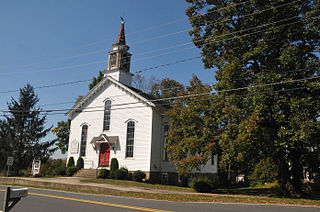
The Readington Reformed Church is a historic church located at 124 Readington Road, Readington Village, an unincorporated community located within Readington Township in Hunterdon County, New Jersey. It was known in colonial times as the Dutch Reformed Church of North Branch. It is the oldest Dutch Reformed Church in the county. The current building was built in 1865. The churchyard is known as the Readington Reformed Church Cemetery. The church was added as a contributing property of the Readington Village Historic District by the National Register of Historic Places on June 24, 1991.


