
Union Township is a township in Hunterdon County, in the U.S. state of New Jersey. The southwest half of the township lies on what is known as the Hunterdon Plateau, the northwest corner consists of the Musconetcong Ridge and the northeast section is part of the lower-lying Newark Basin around Spruce Run Reservoir. As of the 2020 United States census, the township's population was 6,507, its highest ever decennial count and an increase of 599 (+10.1%) from the 2010 census count of 5,908, which in turn reflected a decline of 252 (−4.1%) from the 6,160 counted in the 2000 census.

Chesterfield, originally known as Recklesstown, is an unincorporated community located around the intersection of County Route 528 and County Route 677 in Chesterfield Township of Burlington County, New Jersey.

Blawenburg is an unincorporated community and census-designated place (CDP) located within Montgomery Township, in Somerset County, in the U.S. state of New Jersey. As of the 2010 United States Census, the CDP's population was 280. It is located at the juncture of two large roads, CR 518 and CR 601.

Quakertown is an unincorporated community located within Franklin Township in Hunterdon County, New Jersey. It was once known as Fairview. The area was settled by Quakers from Burlington County, who organized a meeting house here in 1733. The Quakertown Historic District was listed on the state and national registers of historic places in 1990.

Neshanic Station is an unincorporated community and census-designated place (CDP) located within Branchburg and extending into Hillsborough Township, Somerset County, in the U.S. state of New Jersey. In 2016 most of the village was listed on the National Register of Historic Places as the Neshanic Station Historic District.
Cokesbury, historically known as Cokesburg, is an unincorporated community located on the border of Clinton and Tewksbury townships in Hunterdon County, New Jersey. It was named after two Methodist bishops, Coke and Asbury. The Cokesbury Historic District was listed on the state and national registers of historic places in 1997.

Finesville is an unincorporated community and census-designated place (CDP) located within Pohatcong Township in Warren County, in the U.S. state of New Jersey. The CDP was defined as part of the 2010 United States Census. As of the 2010 Census, the CDP's population was 175.

Wallpack Center is an unincorporated community located within Walpack Township, Sussex County, in the U.S. state of New Jersey. Wallpack Center is located in the Flat Brook Valley 6.7 miles (10.8 km) west of Branchville. Wallpack Center has a post office with ZIP Code 07881. It is now part of the Delaware Water Gap National Recreation Area.
Mount Pleasant is an unincorporated community located along County Route 519 on the border of Alexandria Township and Holland Township, in Hunterdon County, New Jersey. The Mount Pleasant Historic District was listed on the National Register of Historic Places in 1987.

Hamden is an unincorporated community located within Clinton Township, in Hunterdon County, in the U.S. state of New Jersey.

Harbourton is an unincorporated community located within Hopewell Township in Mercer County, in the U.S. state of New Jersey. It is located along County Route 579 at the intersection with Harbourton-Mount Airy Road. The Harbourton Historic District, encompassing the community, was listed on the state and national registers of historic places in 1974.
Amsterdam is an unincorporated community located within Holland Township in Hunterdon County, in the U.S. state of New Jersey. Located on the southern flank of the Musconetcong Mountain, the area was settled in the first half of the 18th century. It was later named after Amsterdam, Netherlands. The Amsterdam Historic District, encompassing the community, was listed on the state and national registers of historic places in 1995.

Cloverhill is an unincorporated community located at the intersection of the boundaries of East Amwell and Raritan townships in Hunterdon County and Hillsborough Township in Somerset County, in the U.S. state of New Jersey. The Clover Hill Historic District was listed on the state and national registers of historic places in 1980.

Reaville is an unincorporated community located along the border of East Amwell and Raritan townships in Hunterdon County, New Jersey. By the 1830s, it was known as Greenville. It was later renamed after Runkle Rea, the first postmaster in 1850.
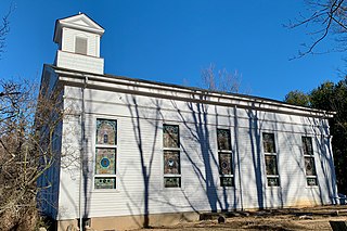
Van Syckel is an unincorporated community located within Union Township in Hunterdon County, New Jersey. The Van Syckel Corner District was listed on the National Register of Historic Places in 1979.

Wertsville is an unincorporated community located along County Route 602 in East Amwell Township of Hunterdon County, in the U.S. state of New Jersey.
The Rockhill Agricultural Historic District is a 1,075-acre (435 ha) historic district located north of Pittstown along County Route 513 in a southern triangular portion of Union Township in Hunterdon County, New Jersey. A small part of the district extends into Franklin Township. The district was added to the National Register of Historic Places on April 5, 1984, for its significance in agriculture during the 18th and 19th centuries.
Middletown Village is an unincorporated community located in the central part of Middletown Township, Monmouth County, New Jersey. It was the first settlement in the township and one of the oldest in New Jersey. The Middletown Village Historic District, encompassing the community, was listed on the state and national registers of historic places in 1974.

The Old Grandin Library is a historic building located at 12 East Main Street in the town of Clinton in Hunterdon County, New Jersey. It was added to the National Register of Historic Places on November 1, 1974, for its significance in architecture and education. It was built in 1898 as a public library for the town with funds from the estate of Daniel F. Grandin. In 1995, it was also listed as a contributing property of the Clinton Historic District.
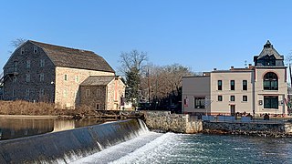
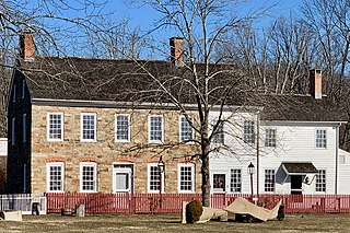
The Clinton Historic District is a 175-acre (71 ha) historic district encompassing much of the town of Clinton in Hunterdon County, New Jersey. It was added to the National Register of Historic Places on September 28, 1995, for its significance in architecture, commerce, engineering, industry and exploration/settlement. The district includes 270 contributing buildings, one contributing structure, and three contributing sites. Five were previously listed on the NRHP individually: Dunham's Mill, M. C. Mulligan & Sons Quarry, Music Hall, Old Grandin Library, and Red Mill.


