Califon is a borough in Hunterdon County, New Jersey, United States. As of the 2010 United States Census, the borough's population was 1,076, reflecting an increase of 21 (+2.0%) from the 1,055 counted in the 2000 Census, which had in turn declined by 18 (-1.7%) from the 1,073 counted in the 1990 Census.

Clinton is a town in Hunterdon County, New Jersey, United States, located on the South Branch of the Raritan River in the Raritan Valley region. As of the 2010 United States Census, the town's population was 2,719, reflecting an increase of 87 (+3.3%) from the 2,632 counted in the 2000 Census, which had in turn increased by 578 (+28.1%) from the 2,054 counted in the 1990 Census. Despite its relatively small population, Clinton is the predominant control city for Interstate 78 traveling westbound from Newark.

The Columbia Trail is a rail trail in rural northwestern New Jersey. It was created from portions of the former Central Railroad of New Jersey High Bridge Branch and stretches from High Bridge, in Hunterdon County, through Washington Township, in Morris County for a total of 15.1 miles (24.3 km). The trail surface is relatively flat and consists mostly of fine crushed stone.

The South Branch Raritan River is a 50-mile-long (80 km) tributary of the Raritan River in New Jersey.

Ken Lockwood Gorge is between Califon and High Bridge in Lebanon Township of Hunterdon County, New Jersey. It was purchased in 1948 by the Division of Fish, Game and Wildlife and has been referred to as “one of New Jersey's most beautiful places.” It is presently administered by the New Jersey Division of Fish and Wildlife.
Readington Village is an unincorporated community located within Readington Township in Hunterdon County, New Jersey, United States, that is centered on the converging of Readington Road, Hillcrest Road, Centerville Road and Brookview Road. It is located on Holland Brook, originally named Amanmechunk, which means large creek in the Unami dialect. The area was inhabited by the Raritan prior to the arrival of European settlers. The Native Americans who lived near Readington Village travelled to the coast during the summer for fish and clams. Such a trip is mentioned in an Indian deed transferring lands around Holland Brook to English and Dutch settlers. The deed mentions two of the natives, who lived at Readington: Metamisco and Wataminian.

The Amwell Valley is a small valley in Hunterdon County, New Jersey, between the Hunterdon Plateau and the Sourlands. It comprises Stockton, parts of Delaware Township, West Amwell, East Amwell, Flemington and Raritan Township. The region borders the Delaware River to the west and the South Branch Raritan River to the east. The entire area has elevations around 200 feet above sea level. US 202 is the main route running west to east through the valley. Old York Road also passes through the valley, taking a generally more southern route through Raritan and along the Sourlands at Mount Airy. Like the Hunterdon Plateau, Amwell Valley still has a large number of farms due to its sufficient climate, relatively flat land and the presence of silt-loams soils. The valley is home to Unionville Winery and Old York Cellars in Ringoes.

Bunnvale is an unincorporated community located within Lebanon Township, Hunterdon County, New Jersey, United States.

The Patriots' Path is a 90-mile (145 km) long multi-use trail system in Morris County, New Jersey.
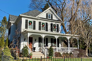
Cokesbury, historically known as Cokesburg, is an unincorporated community located on the border of Clinton and Tewksbury townships in Hunterdon County, New Jersey. It was named after two Methodist bishops, Coke and Asbury. The Cokesbury Historic District was listed on the state and national registers of historic places in 1997.

Little York is an unincorporated community located along the border of Alexandria and Holland townships in Hunterdon County, New Jersey, United States. Little York is located on County Route 614 3.1 miles (5.0 km) north-northeast of Milford. Little York has a post office with ZIP code 08834.

Darts Mills is a historic unincorporated community located within Readington Township in Hunterdon County, New Jersey, United States. It is located on the South Branch of the Raritan River, and several mills were built there in the early 18th century. At its height, a merchant, blacksmith, store and complex of mills were here. The last mill at this site burnt down in 1994. Foundation walls and a mill race remain at the site today. On April 29, 1982, Dart's Mill was added to the National Register of Historic Places.

Hoffmans, also known as Hoffman's Crossing, is an unincorporated community located along Hoffman's Crossing Road and the South Branch Raritan River within Lebanon Township in Hunterdon County, New Jersey. It is about 1.5 miles (2.4 km) from Califon. The main road in the community is County Route 513. The Hunterdon County Educational Services Commission (HCESC) has a campus here.

Rockefellows Mills is an unincorporated community located within Raritan Township in Hunterdon County, New Jersey, United States. The settlement is located along the South Branch Raritan River near Three Bridges. The river is spanned in the area by the historic Rockafellows Mill Bridge built in 1900 and part of the Raritan–Readington South Branch Historic District. Most of the area within the Raritan Township side of the river is forested however on the north side of the river in Readington Township, some farmland dots the area.

Headquarters is an unincorporated community located within the Amwell Valley of Delaware Township in Hunterdon County, New Jersey. The settlement is centered around the intersection of Zentek Road and County Route 604. It is about 3 miles (4.8 km) from Ringoes to the east and 1 mile (1.6 km) from Sergeantsville to the west. The Headquarters Historic District was listed on the state and national registers of historic places in 2011 and had its boundary increased in 2016.

The Asbury Historic District is a 288 acres (117 ha) historic district encompassing the community of Asbury in Franklin Township of Warren County, New Jersey. It is bounded by County Route 632, County Route 643, Maple Avenue, Kitchen Road, and School Street and extends along the Musconetcong River into Bethlehem Township of Hunterdon County. It was listed on the National Register of Historic Places on March 19, 1993 for its significance in architecture, industry, religion, community development, politics/government, and commerce. The district includes 141 contributing buildings, a contributing structure, two contributing sites, and four contributing objects.

Middle Valley is an unincorporated community located along Middle Valley Road and County Route 513 in Washington Township, Morris County, New Jersey. It is near Long Valley in the valley of the South Branch Raritan River. The Middle Valley Historic District was listed on the state and national registers of historic places in 1989 and 1990.

The Main Street Bridge, once known as the West Main Street Bridge, is a historic pony Pratt truss bridge crossing the South Branch Raritan River in Clinton of Hunterdon County, New Jersey. It was designed by Francis C. Lowthorp and built in 1870 by William Cowin of Lambertville. The bridge was added to the National Register of Historic Places on September 28, 1995 as part of the Clinton Historic District. It is one of the few early examples of iron Pratt truss bridges remaining in the United States. It was documented by the Historic American Engineering Record in 1991.
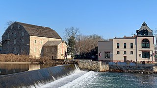
The Clinton Historic District is a 175-acre (71 ha) historic district encompassing much of the town of Clinton in Hunterdon County, New Jersey. It was added to the National Register of Historic Places on September 28, 1995, for its significance in architecture, commerce, engineering, industry and exploration/settlement. The district includes 270 contributing buildings, one contributing structure, and three contributing sites. Five were previously listed on the NRHP individually: Dunham's Mill, M. C. Mulligan & Sons Quarry, Music Hall, Old Grandin Library, and Red Mill.

The Ken Lockwood Gorge Bridge is a steel plate girder bridge built for the High Bridge Branch of the Central Railroad of New Jersey (CNJ) to cross the South Branch Raritan River in Ken Lockwood Gorge of Hunterdon County, New Jersey. It is now open for pedestrian traffic on the Columbia Trail, a rail trail that starts in High Bridge.


