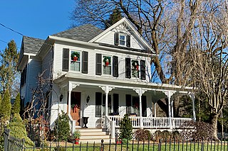
Califon is a borough in Hunterdon County, New Jersey, United States. As of the 2010 United States Census, the borough's population was 1,076, reflecting an increase of 21 (+2.0%) from the 1,055 counted in the 2000 Census, which had in turn declined by 18 (-1.7%) from the 1,073 counted in the 1990 Census.
County Route 512 is a county highway in the U.S. state of New Jersey. The highway extends 32.96 miles (53.04 km) from High Bridge Road in Califon to Springfield Avenue / Route 24 in Summit.

Pittstown is an unincorporated community located at the intersection of the boundaries of Alexandria, Franklin and Union townships in Hunterdon County, New Jersey, United States. The area is named after William Pitt. The area is served as United States Postal Service ZIP Code 08867. The area was named Hofftown in the 18th century after landowner Lawrence Hoff. The Pittstown Historic District was listed on the state and national registers of historic places in 1990.

Quakertown is an unincorporated community located within Franklin Township in Hunterdon County, New Jersey. It was once known as Fairview. The area was settled by Quakers from Burlington County, who organized a meeting house here in 1733. The Quakertown Historic District was listed on the state and national registers of historic places in 1990.

The Fairmount Historic District is a 409-acre (166 ha) historic district located along County Route 517 in the Fairmount section of Tewksbury Township, near Califon, in Hunterdon County, New Jersey. It was added to the National Register of Historic Places on December 20, 1996 for its significance in architecture, exploration/settlement, and industry. The district includes 72 contributing buildings that were deemed to be contributing to the historic character of the area, plus five contributing structures, nine contributing sites, and one contributing object. One contributing building is located in Washington Township, Morris County.
Cokesbury, historically known as Cokesburg, is an unincorporated community located on the border of Clinton and Tewksbury townships in Hunterdon County, New Jersey. It was named after two Methodist bishops, Coke and Asbury. The Cokesbury Historic District was listed on the state and national registers of historic places in 1997.

Readingsburg, also known as Stone Mill, is an unincorporated community located along the South Branch Raritan River within Clinton Township in Hunterdon County, New Jersey.
Amsterdam is an unincorporated community located within Holland Township in Hunterdon County, New Jersey. Located on the southern flank of the Musconetcong Mountain, the area was settled in the first half of the 18th century. It was later named after Amsterdam, Netherlands. The Amsterdam Historic District, encompassing the community, was listed on the state and national registers of historic places in 1995.

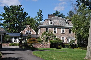
The Oldwick Historic District is a 170-acre (69 ha) national historic district located along County Route 517, Church, King, James, Joliet and William streets in the Oldwick section of Tewksbury Township in Hunterdon County, New Jersey. The district was added to the National Register of Historic Places on November 14, 1988, for its significance in architecture, commerce, and industry. It includes 127 contributing buildings, 12 contributing structures, and one contributing site. The Kline Farmhouse, listed individually in 1984, also contributes to the district. Many of the buildings were documented by the Historic American Buildings Survey.
Van Syckel is an unincorporated community located within Union Township in Hunterdon County, New Jersey. The Van Syckel Corner District was listed on the National Register of Historic Places in 1979.

Headquarters is an unincorporated community located within the Amwell Valley of Delaware Township in Hunterdon County, New Jersey. The settlement is centered around the intersection of Zentek Road and County Route 604. It is about 3 miles (4.8 km) from Ringoes to the east and 1 mile (1.6 km) from Sergeantsville to the west. The Headquarters Historic District was listed on the state and national registers of historic places in 2011 and had its boundary increased in 2016.
The Miller Farmstead is a historic district encompassing the main farm complex on Route 57, at Watters Road, in Mansfield Township, Warren County, New Jersey and extending into Lebanon Township, Hunterdon County. The farmstead is near the community of Penwell and overlooks the Musconetcong River, arranged linearly along the upper edge of the river's flood plain. It was added to the National Register of Historic Places on September 11, 1989, for its significance in agriculture, architecture, and transportation from 1830 to 1924. The listing is a 108 acres (44 ha) area that includes eight contributing buildings, seven contributing structures, and a contributing site.
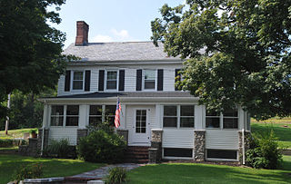
Lansdown, also known as the Charles Stewart Plantation, is a historic house located on Hamden Road along the South Branch Raritan River in the village of Lansdowne, northeast of Pittstown, in Franklin Township, Hunterdon County, New Jersey. It was added to the National Register of Historic Places on November 2, 1979, for its significance in architecture, military, and politics/government.

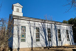
The Quaker Meeting House is a historic Quaker meeting house at the intersection of Quakertown Road and White Bridge Road in the Quakertown section of Franklin Township in Hunterdon County, New Jersey. In 1733, Quaker settlers acquired four acres of land here and built a log house for their first meeting house. A stone church was built here in 1754. The current building is a reconstruction built in 1862 using the original stones from that church. It is a key contributing property of the Quakertown Historic District, which was added to the National Register of Historic Places on August 23, 1990. The adjoining burial ground is also contributing to the district. The building is the only Quaker meeting house constructed in Hunterdon County.
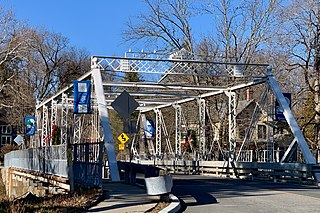
The Main Street Bridge, historically known as the Califon Bridge, is a Pratt thru truss bridge that carries Main Street over the South Branch Raritan River in Califon, Hunterdon County, New Jersey. The bridge was added to the National Register of Historic Places on October 14, 1976 as part of the Califon Historic District.

The Turner–Chew–Carhart Farm, also known as the Jockey Hollow Farm, is a historic 57-acre (23 ha) farm located off Van Syckles Road in Union Township, Hunterdon County, New Jersey and near Clinton. It was added to the National Register of Historic Places on August 11, 1977, for its significance in agriculture, architecture, industry, and politics/government. The farmstead includes seven contributing buildings.

The Case-Dvoor Farmstead is located on a 40-acre (16 ha) farm at 111 Mine Street in Raritan Township, near Flemington, of Hunterdon County, New Jersey. It was added to the National Register of Historic Places on December 11, 2009, for its significance in agriculture and architecture. It is now the headquarters of the Hunterdon Land Trust.

The District No. 98 Schoolhouse, also known as the Stockton School, is a historic school located at 19 South Main Street in the borough of Stockton in Hunterdon County, New Jersey. It was added to the National Register of Historic Places on January 12, 2005, for its significance in education.

The Kline Farmhouse, also known as Cold Spring Cottage, is located on a 12-acre (4.9 ha) farm along County Route 517, north of Oldwick in Tewksbury Township of Hunterdon County, New Jersey. Built by Jacob Kline in the 1790s, it was added to the National Register of Historic Places on July 11, 1984, for its significance in agriculture, architecture and settlement. Also known as the Beavers House, it was previously documented by the Historic American Buildings Survey in 1966. It was later listed as a contributing property of the Oldwick Historic District in 1988.

The Case Farmstead, also known as the Daniel Case / Sarah Clark Case Farmstead, is a historic 88-acre (36 ha) farm located along County Route 614 near Pattenburg in Union Township, Hunterdon County, New Jersey. It was added to the National Register of Historic Places on August 14, 1979, for its significance in architecture and medicine. The farmstead includes three contributing buildings.


