
Daggett County is a county in the northeastern corner of the U.S. state of Utah. As of the 2020 United States Census, the population was 935, making it the least populous county in Utah. Its county seat is Manila. The county was named for Ellsworth Daggett, the first surveyor-general of Utah. The small community of Dutch John, located near the state line with Colorado and Wyoming, became an incorporated town in January 2016.

Hunterdon County is a county located in the western section of the U.S. state of New Jersey. At the 2020 census, the county was the state's 18th-most populous county, with a population of 128,947, its highest decennial count ever and an increase of 598 (+0.5%) from the 2010 census count of 128,349, which in turn reflected an increase of 6,360 (5.2%) from the 121,989 counted in the 2000 census. Its county seat is Flemington.

Le Sueur County is a county located in the south central portion of the U.S. state of Minnesota. As of the 2020 census, the population was 28,674. Its county seat is Le Center.

Glassboro is a borough within Gloucester County, in the U.S. state of New Jersey, within the Philadelphia metropolitan area. As of the 2020 United States census, the borough's population was 23,149, its highest decennial count ever and an increase of 4,570 (+24.6%) from the 18,579 recorded at the 2010 census, which in turn had reflected a decline of 489 (−2.6%) from the 19,068 counted at the 2000 census. Much of the recent and projected growth in Glassboro have been attributed to the growth trajectory of Rowan University, founded in 1923 and formerly known as Glassboro State College. Glassboro and surrounding Gloucester County constitute part of South Jersey.
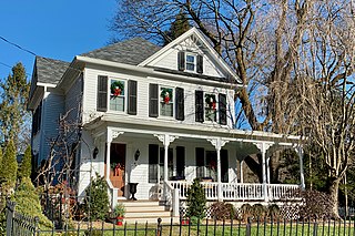
Califon is a borough in Hunterdon County, in the U.S. state of New Jersey. As of the 2020 United States census, the borough's population was 1,005, a decrease of 71 (−6.6%) from the 2010 census count of 1,076, which in turn reflected an increase of 21 (+2.0%) from the 1,055 counted in the 2000 census.
Clinton is a town in Hunterdon County, in the U.S. state of New Jersey. It is located on the South Branch of the Raritan River in the Raritan Valley region. As of the 2020 United States census, the town's population was 2,773, an increase of 54 (+2.0%) from the 2010 census count of 2,719, which in turn reflected an increase of 87 (+3.3%) from the 2,632 counted in the 2000 census. Despite its relatively small population, Clinton is the predominant control city for Interstate 78 traveling westbound from Newark.

Clinton Township is a township in Hunterdon County, in the U.S. state of New Jersey. As of the 2020 United States census, the township's population was 13,505, an increase of 27 (+0.2%) from the 2010 census count of 13,478, which in turn reflected an increase of 521 (+4.0%) from the 12,957 counted in the 2000 census.

High Bridge is a borough in Hunterdon County, in the U.S. state of New Jersey. As of the 2020 United States census, the borough's population was 3,546, a decrease of 102 (−2.8%) from the 2010 census count of 3,648, which in turn reflected a decline of 128 (−3.4%) from the 3,776 counted in the 2000 census.

Lebanon is a borough in Hunterdon County,in the U.S. state of New Jersey. As of the 2020 United States census, the borough's population was 1,665, the highest ever in any decennial census and an increase of 307 (+22.6%) from the 2010 census count of 1,358, which in turn reflected an increase of 293 (+27.5%) from the 1,065 counted in the 2000 census.
Lebanon Township is the northernmost township in Hunterdon County, in the U.S. state of New Jersey. As of the 2020 United States census, the township's population was 6,195, a decrease of 393 (−6.0%) from the 2010 census count of 6,588, which in turn reflected an increase of 772 (+13.3%) from the 5,816 counted in the 2000 census.
Millstone Township is a township in western Monmouth County, in the U.S. state of New Jersey. The Township is located within the Raritan Valley region and is a part of the New York metropolitan area. As of the 2020 United States census, the township's population was 10,376, a decrease of 190 (−1.8%) from the 2010 census count of 10,566, which in turn reflected an increase of 1,596 (+17.8%) from the 8,970 counted in the 2000 census.

Plumsted Township is a township in Ocean County, in the U.S. state of New Jersey. As of the 2020 United States census, the township's population was 8,072, a decrease of 349 (−4.1%) from the 2010 census count of 8,421, which in turn reflected an increase of 1,146 (+15.8%) from the 7,275 counted in the 2000 census. The 2010 population was the highest recorded in any decennial census.

Fortescue is a community and census-designated place (CDP) in Downe Township, Cumberland County, in the U.S. state of New Jersey. The community is located on the state's southern coast, on the Delaware Bay, surrounded on three sides by marshland. It has a population of about 400. The area was named for John Fortescue, a local property owner at the time of American independence. As of the 2020 United States census, the CDP's population was 189.

Beury Mountain Wildlife Management Area is located on 9,232 acres (3,736 ha) near Babcock State Park and New River Gorge National River in Fayette County, West Virginia. Beury Mountain's sloping terrain is covered with mixed hardwoods and oak-hickory second growth woodlands overlooking New River Gorge. Camping is not allowed at Beury Mountain WMA, but is available at nearby Babcock State Park.

Ken Lockwood Gorge is between Califon and High Bridge in Lebanon Township of Hunterdon County, New Jersey. It was purchased in 1948 by the Division of Fish, Game and Wildlife and has been referred to as “one of New Jersey's most beautiful places.” It is presently administered by the New Jersey Division of Fish and Wildlife.

Readingsburg, also known as Stone Mill, is an unincorporated community located along the South Branch Raritan River within Clinton Township in Hunterdon County, New Jersey.

Hoffmans, also known as Hoffman's Crossing, is an unincorporated community located along Hoffman's Crossing Road and the South Branch Raritan River within Lebanon Township in Hunterdon County, New Jersey. It is about 1.5 miles (2.4 km) from Califon. The main road in the community is County Route 513. The Hunterdon County Educational Services Commission (HCESC) has a campus here.

Cooleys Corner is an unincorporated community located within Upper Freehold Township in Monmouth County, in the U.S. state of New Jersey. The site of the settlement is within the Assunpink Wildlife Management Area, a New Jersey Department of Environmental Protection Division of Fish and Wildlife-operated preserved area in Monmouth and Mercer counties along the Assunpink Creek. Before the creation of the Assunpink Lake in the 1970s, the area consisted of farmland located at the intersection of Clarksburg Road and Imlaystown-Hightstown Road. Some farmland is still present in the area but is now mostly used by hunters. The main boat ramp to Assunpink Lake is located along the former Imlaystown-Hightstown Road.


