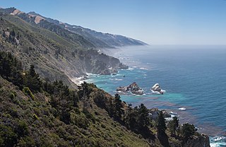
Big Sur is a rugged and mountainous section of the Central Coast of the U.S. state of California, between Carmel Highlands and San Simeon, where the Santa Lucia Mountains rise abruptly from the Pacific Ocean. It is frequently praised for its dramatic scenery. Big Sur has been called the "longest and most scenic stretch of undeveloped coastline in the contiguous United States", a sublime "national treasure that demands extraordinary procedures to protect it from development", and "one of the most beautiful coastlines anywhere in the world, an isolated stretch of road, mythic in reputation". The views, redwood forests, hiking, beaches, and other recreational opportunities have made Big Sur a popular destination for visitors from across the world. With 4.5 to 7 million visitors annually, it is among the top tourist destinations in the United States, comparable to Yosemite National Park, but with considerably fewer services, and less parking, roads, and related infrastructure.
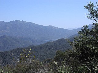
Los Padres National Forest is a United States national forest in southern and central California. Administered by the United States Forest Service, Los Padres includes most of the mountainous land along the California coast from Ventura to Monterey, extending inland. Elevations range from sea level to 8,847 feet (2,697 m).

Carson National Forest is a national forest in northern New Mexico, United States. It encompasses 6,070 square kilometers and is administered by the United States Forest Service. The Forest Service's "mixed use" policy allows for its use for recreation, grazing, and resource extraction.

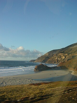
The Big Sur River is a 15.7-mile-long (25.3 km) river on the Central Coast of California. The river drains a portion of the Big Sur area, a thinly settled region of the Central California coast where the Santa Lucia Mountains rise abruptly from the Pacific Ocean. The upper river and watershed lies within the Ventana Wilderness and encompasses the headwaters downstream to the area known as the Gorge. The lower river flows roughly northwest through Pfeiffer Big Sur State Park, the Big Sur village, several private camp grounds and Andrew Molera State Park where it flows through a lagoon and sandbar into the Pacific Ocean at the Monterey Bay National Marine Sanctuary. Major Tributaries of the river include, in order: Redwood Creek, Lion Creek, Logwood Creek, Terrace Creek, Ventana Creek, Post Creek, Pfeiffer-Redwood Creek, Juan Higuera Creek, and Pheneger Creek.
The Little Sur River is a 25.4-mile (40.9 km) long river on the Central Coast of California. The river and its main tributary, the South Fork, drain a watershed of about 40 square miles (100 km2) of the Big Sur area, a thinly settled region of the Central California coast where the Santa Lucia Mountains rise abruptly from the Pacific Ocean. The South Fork and the North Fork both have their headwaters in the Ventana Wilderness, straddling Mount Pico Blanco. Portions west of the national forest and Old Coast Road lie within the El Sur Ranch. Some portions of the North Fork are on land owned by Granite Rock Company of Watsonville, California, which has owned the mineral rights to 2,800 acres (1,100 ha) on Mount Pico Blanco since 1963. The North and South forks converge about 2 miles (3.2 km) from the coast where the river enters the Pacific Ocean.
The Ventana Wilderness of Los Padres National Forest is a federally designated wilderness area located in the Santa Lucia Range along the Central Coast of California. This wilderness was established in 1969 when the Ventana Wilderness Act redesignated the 55,800-acre (22,600 ha) Ventana Primitive Area as the Ventana Wilderness and added land, totalling 98,000 acres. In 1978, the Endangered American Wilderness Act added 61,000 acres, increasing the total wilderness area to about 159,000 acres. The California Wilderness Act of 1984 added about 2,750 acres. The Los Padres Condor Range and River Protection Act of 1992 created the approximately 14,500-acre (5,900 ha) Silver Peak Wilderness and added about 38,800 acres to the Ventana Wilderness in addition to designating the Big Sur River as a Wild and Scenic River. The Big Sur Wilderness and Conservation Act of 2002 expanded the wilderness for the fifth time, adding nearly 35,000 acres (14,000 ha), increasing the total acreage of the wilderness to its present size of 240,026 acres (97,135 ha).

Jennie Lakes Wilderness is a protected area in the Sierra Nevada, in Tulare County, California. It is located 60 miles (97 km) east of Fresno and managed by the US Forest Service. Jennie Lakes Wilderness is about nine square miles within the Sequoia National Forest, that was established by the California Wilderness Act of 1984, and added to the National Wilderness Preservation System.
The Pine Ridge Trail is the most popular hiking trail in the Ventana Wilderness of the Los Padres National Forest, California. The 19.5 miles (31.4 km) trail traverses the Ventana Wilderness from the Big Sur Station near sea level to China Camp on Tassajara Road at 5,000 feet (1,500 m). Built in 1916 by the Post family of Big Sur, the Pine Ridge Trail offers hikers and equestrians an array of backcountry camps to enjoy.
The Ventana Double Cone at 4,856 feet (1,480 m) is one of the tallest peaks in the Ventana Wilderness within the Monterey Ranger District of the Los Padres National Forest in Central California. The summit is a difficult 14.7 miles (23.7 km) hike from the nearest trail head, making it one of the more distant locations in the wilderness. The last 4 miles (6.4 km) portion of the trail from Little Pines to the summit is not well used and often overgrown with chaparral. There are a few Santa Lucia Firs near the summit.

Sykes Camp is located 10 miles (16 km) from the Pfeiffer Big Sur State Park trailhead along the Pine Ridge Trail. There were seven campsites along both sides of the Big Sur River upstream and downstream from where the trail intersects the river. There was a pit toilet downstream of this intersection.

Camp Pico Blanco is an inactive camp of 618 acres (250 ha) in the interior region of Big Sur in Central California. It is operated by the Silicon Valley Monterey Bay Council, of the Boy Scouts of America, a new council formed as a result of a merger between the former Santa Clara County Council and the Monterey Bay Area Council in December 2012. The camp is surrounded by the Los Padres National Forest, the Ventana Wilderness, undeveloped private land owned by Graniterock, and is located astride the pristine Little Sur River. The land was donated to the Boy Scouts by William Randolph Hearst in 1948 and the camp was opened in 1955. The camp was closed following the Soberanes Fire in 2017, and remained closed after Palo Colorado Road was severely damaged the following winter. Monterey County has been unable to budget the funds required to fix the road. In April 2022, the Silicon Valley Monterey Bay Council announced that the 18 acres (7.3 ha) camp and its buildings were for sale for $1.8 million, and also offered an adjacent 350 acres (140 ha) of undeveloped wilderness for $1.6 million.
Poudre Wilderness Volunteers (PWV) is a volunteer group that assists the Canyon Lakes Ranger District of the US Forest Service (USFS). Poudre Wilderness Volunteers recruits and trains volunteers to serve as wilderness rangers and hosts for the purpose of educating the public and providing other support to the USFS.
The Rock Creek Roadless Area (B032) is located northwest of Buffalo, Wyoming, in the Bighorn National Forest. It comprises roughly 34,000 acres (140 km2) of forested timberlands, mountain parks, rugged canyons, and stunning rock formations. This area represents the entire spectrum of environments found in the Bighorn National Forest and encompasses prairie land to high alpine peaks. This roadless area is the source of the north, middle, and south forks of Rock Creek, Balm of Gilead Creek, Pheasant Creek, and Ditch Creek. The area is flanked on the eastern side by the Bud Love Big Game Winter Range and the HF Bar Ranch Historic District. On the southern side the roadless area is surrounded by the Paradise Guest Ranch. The roadless area is home to elk, moose, mountain lion, pine marten, blue grouse, ruffed grouse, and raptors. The Rock Creek area is the largest area of quality elk security habitat outside of the Cloud Peak Wilderness Area and would provide an important corridor from the high country to the Bud Love Habitat Management Unit. The Rock Creek roadless area is dominated by lodgepole pine, some ponderosa, and aspen stands with low-growing juniper in the undergrowth. The area has not been opened to roads due to the ruggedness of the landscape and the high costs of implementation.

The Big Sur Land Trust is a private 501(c)(3) non-profit located in Monterey, California, that has played an instrumental role in preserving land in California's Big Sur and Central Coast regions. The trust was the first to conceive of and use the "conservation buyer" method in 1989 by partnering with government and developers to offer tax benefits as an inducement to sell land at below-market rates. Since 1978, with the support of donors, funders and partners, it has conserved over 40,000 acres through conservation easements, acquisition and transfer of land to state, county and city agencies. It has placed conservation easements on 7,000 acres and has retained ownership of over 4,000 acres.

The Los Padres Condor Range and River Protection Act of 1992 is a Federal law that established five new designated Wilderness Areas and three new designated Wild and Scenic Rivers in the Los Padres National Forest and Angeles National Forest in California. The law was sponsored by California Republican and Ventura County native Robert J. Lagomarsino while he represented California's 19th District in the United States House of Representatives. The legislation was cosponsored by Democratic and Republican representatives from districts representing the entirety of the Los Padres National Forest.
The El Sur Ranch, located on the Big Sur coast of California, has been continuously operated as a cattle ranch since 1834. The approximately 7,100 acres (2,873 ha) ranch straddles Highway 1 for 6 miles (9.7 km) from the mouth of the Little Sur River to the mouth of the Big Sur River and Andrew Molera State Park. Both the ranch and the park originally comprised the Rancho El Sur land grant given in 1834 by Governor José Figueroa to Juan Bautista Alvarado. It has been owned by the Hill family since 1955, who operate a commercial cow-calf operation.

Cone Peak is the second highest mountain in the Santa Lucia Range in the Ventana Wilderness of the Los Padres National Forest. It rises nearly a vertical mile only 3 miles (4.8 km) from the coast as the crow flies. This is one of the steepest gradients from ocean to summit in the contiguous United States. The average gradient from sea level to summit is around 33%, which is steeper than the average gradient from Owens Valley to the summit of Mount Whitney. Near the mountain summit, the oak woodland and chaparral transitions to a pine forest with a few rare Santa Lucia Firs. Junipero Serra Peak at 5,865 feet (1,788 m) is the highest peak in the coastal region.

Pico Blanco is a peak on the coast of Big Sur in the Santa Lucia Range of the Los Padres National Forest. The Little Sur River and its tributaries almost surround the mountain. The North Fork wraps around the northern flank and eastern edge of the mountain, and the South Fork crosses the mountain to the west and south-west. The mountain is known for an extremely high-grade limestone deposit. The peak and surrounding 2,800 acres (1,100 ha), are owned by the Granite Rock Company of Watsonville, California. The lower western slopes of the mountain are the property of the El Sur Ranch. The Old Coast Road built in the early 1900s cuts across its western flank. The view from its summit allows hikers to see Ventana Double Cone and Kandlbinder Peak to the southeast, as well as a host of other Big Sur peaks: Mt. Manuel, Post Summit, Uncle Sam Mtn., and Cone Peak far to the south. The mountain is central to the creation story of the Esselen people.

Bottchers Gap is a day-use area, campground, and trailhead in Monterey County, California. It is located 7.6 miles (12.2 km) from the Big Sur Coast Highway at the end of Palo Colorado Road on the northern border of the Los Padres National Forest and Ventana Wilderness. It is located between Mescal Ridge and Skinner Ridge. From Bottchers Gap, there is an 3.3-mile-long (5.3 km) private access road that leads to Camp Pico Blanco. Beginning at Bottchers Gap, it is a difficult 14.7-mile (23.7 km) hike via the Skinner Ridge and Ventana Double Cone trails to the Ventana Double Cone, making it one of the more remote locations in the wilderness.