
Rimini is a city in the Emilia-Romagna region of Northern Italy.

Emilia-Romagna is an administrative region of northern Italy, comprising the historical regions of Emilia and Romagna. Its capital is Bologna. It has an area of 22,446 km2 (8,666 sq mi), and a population of 4.4 million.

The Rubicon is a shallow river in northeastern Italy, just south of Cesena and north of Rimini. It was known as Fiumicino until 1933, when it was identified with the ancient river Rubicon, famously crossed by Julius Caesar in 49 BC.

Ticinum was an ancient city of Gallia Transpadana, founded on the banks of the river of the same name a little way above its confluence with the Padus (Po).

Romagna is an Italian historical region that approximately corresponds to the south-eastern portion of present-day Emilia-Romagna in northern Italy.

Cisalpine Gaul was the name given, especially during the 4th and 3rd centuries BC, to a region of land inhabited by Celts (Gauls), corresponding to what is now most of northern Italy.

The Via Aurelia is a Roman road in Italy constructed in approximately 241 BC. The project was undertaken by Gaius Aurelius Cotta, who at that time was censor. Cotta had a history of building roads for Rome, as he had overseen the construction of a military road in Sicily connecting Agrigentum and Panormus.

Regio VI Umbria is the name for one of the 11 administrative regions into which the emperor Augustus divided Italy. The main source for the regions is the Historia Naturalis of Pliny the Elder, who informs his readers he is basing the geography of Italy on the descriptio Italiae, "division of Italy", made by Augustus. The Regio Sexta is called Umbria complexa agrumque Gallicam citra Ariminium.

Italia, also referred to as Roman Italy, was the homeland of the ancient Romans. According to Roman mythology, Italy was the ancestral home promised by Jupiter to Aeneas of Troy and his descendants, Romulus and Remus, who were the founders of Rome. Aside from the legendary accounts, Rome was an Italic city-state that changed its form of government from Kingdom to Republic and then grew within the context of a peninsula dominated by the Gauls, Ligures, Veneti, Camunni and Histri in the North, the Etruscans, Latins, Falisci, Picentes and Umbri tribes in the Centre, and the Iapygian tribes, the Oscan tribes, and Greek colonies in the South.
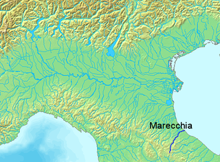
The Marecchia is a river in eastern Italy, flowing from near Monte dei Frati in the province of Arezzo, Tuscany, to the Adriatic Sea in Rimini, Emilia-Romagna. Along its course, the river passes next to or near the settlements of Novafeltria, Verucchio, and Santarcangelo di Romagna. It passes near the Republic of San Marino. Among its tributaries are the San Marino river and the Ausa.

The Via Julia Augusta is the name given to the Roman road formed by the merging of the Via Aemilia Scauri with the Via Postumia.

Santarcangelo di Romagna is a comune in the province of Rimini, in the Italian region of Emilia-Romagna, on the Via Emilia. As of 2009, it had a population of some 21,300. It is crossed by two rivers, the Uso and the Marecchia.

Calendasco is a comune (municipality) in the Province of Piacenza in the Italian region Emilia-Romagna, located about 150 kilometres (93 mi) northwest of Bologna and about 9 kilometres (6 mi) northwest of Piacenza.

The Ausa is a minor river some 17 kilometres (11 mi) long that traverses part of northern San Marino and Emilia–Romagna in Italy.

The Bridge of Tiberius, historically also the Bridge of Augustus or the Bridge of Saint Julian, is a Roman bridge in Rimini, in the region of Emilia-Romagna, northern Italy.

The Reno is a river of Emilia-Romagna and Tuscany, northern Italy. At 211 km (131 mi), it is the tenth longest river in Italy and the most important of the region apart from the Po.
Emilia is a historical region of northern Italy, which approximately corresponds to the western and the north-eastern portions of the modern region of Emilia-Romagna, with the area of Romagna forming the remainder of the modern region.
Le Strade dei vini e dei sapori is the name for the collection of routes in and around Italy, that lead to and through major regional food and wine production areas.

The RomanBridge of San Vito, also locally known as the Pontaccio, was a Roman bridge in San Vito, a frazione on the borders of Rimini, Santarcangelo di Romagna, and San Mauro Pascoli, in the region of Emilia-Romagna, northern Italy.
San Vito is a town in Emilia-Romagna, northern Italy. The town is divided between the comuni of Rimini and Santarcangelo di Romagna, both in the Province of Rimini, with a northern part in San Mauro Pascoli, in the Province of Forlì-Cesena. Culturally, the town is closest to Santarcangelo.


