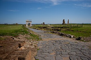
Veii was an important ancient Etruscan city situated on the southern limits of Etruria and 16 km (9.9 mi) north-northwest of Rome, Italy. It now lies in Isola Farnese, in the comune of Rome. Many other sites associated with and in the city-state of Veii are in Formello, immediately to the north. Formello is named after the drainage channels that were first created by the Veians.

Falisci is the ancient Roman exonym for an Italic tribe who lived in what is now northern Lazio, on the Etruscan side of the Tiber River. They spoke an Italic language, Faliscan, closely akin to Latin. Originally a sovereign state, politically and socially they supported the Etruscans, joining the Etruscan League. This conviction and affiliation led to their ultimate near destruction and total subjugation by Rome.
The Via Flaminia was an ancient Roman road leading from Rome over the Apennine Mountains to Ariminum (Rimini) on the coast of the Adriatic Sea, and due to the ruggedness of the mountains was the major option the Romans had for travel between Etruria, Latium, Campania, and the Po Valley. The section running through northern Rome is where Constantine the Great, allegedly, had his famous vision of the Chi Rho, leading to his conversion to Christianity and the Christianization of the Roman Empire.

Blera is a small town and comune in the northern Lazio region of Italy. It was known during the Middle Ages as Bieda, an evolved form of its ancient name, which was restored in the twentieth century. It is the birthplace of Pope Sabinian; Pope Paschal II was also originally thought to be from here.
The Garfagnana is a historical and geographical region of central Italy, today part of the province of Lucca, in Tuscany. It is the upper valley or basin of the river Serchio, and thus lies between the main ridge of the Northern Apennines to the north-east and the Alpi Apuane to the west. The principal towns are Castelnuovo di Garfagnana and Barga.

The Via Aurelia is a Roman road in Italy constructed in approximately 241 BC. The project was undertaken by Gaius Aurelius Cotta, who at that time was censor. Cotta had a history of building roads for Rome, as he had overseen the construction of a military road in Sicily connecting Agrigentum and Panormus.

Vetralla is a town and comune in the province of Viterbo, in central Italy, 11 kilometres (7 mi) south of that city, located on a shoulder of Monte Fogliano.

The Via Cassia was an important Roman road striking out of the Via Flaminia near the Milvian Bridge in the immediate vicinity of Rome and, passing not far from Veii, traversed Etruria. The Via Cassia passed through Baccanae, Sutrium, Volsinii, Clusium, Arretium, Florentia, Pistoria, and Luca, joining the Via Aurelia at Luna.
Tuscania is a town and comune in the province of Viterbo, Lazio Region, Italy. Until the late 19th century the town was known as Toscanella.
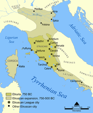
Caere is the Latin name given by the Romans to one of the larger cities of southern Etruria, the modern Cerveteri, approximately 50–60 kilometres north-northwest of Rome. To the Etruscans it was known as Cisra, to the Greeks as Agylla and to the Phoenicians as 𐤊𐤉𐤔𐤓𐤉𐤀.
Forum Clodii, is a post station on the Via Clodia, about 23 miles (37 km) northwest of Rome, situated above the western bank of the Lacus Sabatinus, and connected with the Via Cassia at Vacanae by a branch road which ran round the north side of the lake.

Saturnia is a spa town in Tuscany in north-central Italy that has been inhabited since ancient times. It is a frazione of the comune of Manciano, in the province of Grosseto. Famous for the spa which gives it its name, its population is 280.
Vulci or Volci was a rich Etruscan city in what is now northern Lazio, central Italy.
Nepi is a town and comune in the province of Viterbo, Lazio, central Italy. The town lies 30 kilometres (19 mi) southeast of the city of Viterbo and about 13 kilometres (8 mi) southwest from Civita Castellana.

Capranica is a comune (municipality) in the Province of Viterbo in the Italian region Lazio, located about 55 kilometres (34 mi) northwest of GRA, 66 kilometres (41 mi) from Rome’s centre, and 24.5 kilometres (15.2 mi) southeast of Viterbo.

Luni is a comune (municipality) in the province of La Spezia, in the easternmost end of the Liguria region of northern Italy. It was founded by the Romans as Luna. It gives its name to Lunigiana, a region spanning eastern Liguria and northern Tuscany.

Like the Egyptians, Phoenicians and Carthaginians, the Etruscans were rather slow to adopt the invention of coinage. The brief period of Etruscan coinage, with the predominance of marks of value, seems to be an amalgam that reconciles two very different monetary systems: the 'primitive' bronze-weighing and aes grave economy of central Italy with that of struck silver and gold issues of southern Italian Greek type not familiar in Etruria.
The Estate of San Liberato is an area of woodland and hills near Lake Bracciano in Italy, near Rome. The land was once the city of Forum Clodii, and is designated as an area of outstanding natural beauty. It is named after the Romanesque church founded on this site by the Augustinian Monks.

Florentia was a Roman city in the Arno valley from which Florence originated. According to tradition, it was built by the legions of Gaius Julius Caesar in 59 BC; however, the prevailing hypothesis dates the foundation of the city to the Augustan period.