This article needs additional citations for verification .(July 2018) |
The Via Laurentina is the name borne by an ancient and a modern road of Italy, both leading southwards from Rome.
This article needs additional citations for verification .(July 2018) |
The Via Laurentina is the name borne by an ancient and a modern road of Italy, both leading southwards from Rome.
The question of the nomenclature of the group of roads between the Via Ardeatina and the Via Ostiensis is somewhat difficult, and much depends on the view taken as to the site of Laurentum. It seems probable, however, that the Via Laurentina proper is that which led out of the Porta Ardeatina of the Aurelian Wall and went direct to Tor Paterno, while the road branching from the Via Ostiensis at the third mile, and leading past Decimo to Lavinium (Pratica), which crosses the other road at right angles not far from its destination (the Laurentina there running SW and that to Lavinium SE) may for convenience be called Lavinatis, though this name does not occur in ancient times. On this latter road, beyond Decimo, two milestones, one of Tiberius, the other of Maxentius, each bearing the number II, have been found; and farther on, at Capocotta, traces of ancient buildings, and an important sepulchral inscription of a Jewish ruler of a synagogue have come to light. That the Via Laurentina was near the Via Ardeatina is clear from the fact that the same contractor was responsible for both roads. Laurentum was also accessible by a branch from the Via Ostiensis at the eighth mile (at Malafede) leading past Castel Porziano, the President of Republic estate, which is identical with the ancient Ager Solonius (in which, Festus tells us, was situated the Pomonal or sacred grove of Pomona) and which later belonged to Gaius Marius. [1]

The modern road begins in Rome, in the Ostiense district, separating itself from the consular road Via Ostiense precisely under a railway bridge of the Rome–Lido railway and the Rome Metro B underground: this place, at a short distance from the Basilica di San Paolo fuori le mura, was known since the 16th century as the Ponticello di San Paolo, because of a short bridge now covered by the current road that allowed the crossing of the Via Ostiense on the marrana of Grotta Perfetta, which at a short distance from there discharges into the Tiber.
The Via Laurentina, leading towards south, first delimits the border between the districts of Eur (to the west) and Ardeatino and Giuliano-Dalmata (to the east), then between the Fonte Ostiense area and the Giuliano-Dalmata district: it then divides the Vallerano and Castel di Decima areas from the Castel di Leva area. Leaving Rome, at the intersection with the road to Albano, it crosses Santa Procula, a hamlet of Pomezia, then crosses the SS148 state road (via Pontina), which leads to Latina, and finally arrives to Ardea.
After Ardea the road ends at the seaside resort of Tor San Lorenzo where it flows into the SS601 state road Ostia-Anzio (via Litoranea).
Along the road, at km 14, it lies the Laurentino Cemetery. It contains a portion called the Garden of Angels, dedicated to deceased children and unborn babies. Pope Francis said the annual Papal Mass for All Souls Day in the Garden in 2018. [2]
Lavinium was a port city of Latium, 6 km (3.7 mi) to the south of Rome, midway between the Tiber river at Ostia and Antium. The coastline then, as now, was a long strip of beach. Lavinium was on a hill at the southernmost edge of the Silva Laurentina, a dense laurel forest, and the northernmost edge of the Pontine Marshes, a vast malarial tract of wetlands. The basis for the port, the only one between Ostia and Antium, was evidently the mouth of the Numicus river.

Via Severiana was an ancient Roman road in central Italy leading in Latium, running southeast from Portus to Tarracina, a distance of 80 Roman miles along the coast. A restoration and reunion of existing roads was carried out with a work of lastrification in 198–209 AD, during the reign of emperor Septimius Severus, in order to connect more quickly the maritime towns of Ostia, Lavinium, Ardea, Antium and the routes that came there from Rome.

Ardea is an ancient town and comune (municipality) in the Metropolitan City of Rome Capital, 35 kilometres south of Rome and about 4 kilometres from today's Mediterranean coast.

The Aurelian Walls are a line of city walls built between 271 AD and 275 AD in Rome, Italy, during the reign of the Roman Emperor Aurelian. They superseded the earlier Servian Wall built during the 4th century BC.

The city of Rome, Italy, is divided into first-level administrative subdivisions.
Testaccio is the 20th rione of Rome, Italy, identified by the initials R. XX, deriving its name from Monte Testaccio. It is located within the Municipio I.

San Saba is the 21st rione of Rome, Italy, identified by the initials R. XXI. It is located within the Municipio I, and takes its name from the Basilica of San Saba, which is located there.

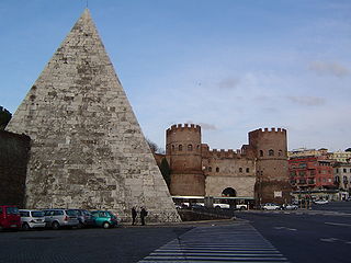
The Porta San Paolo is one of the southern gates in the 3rd-century Aurelian Walls of Rome, Italy. The Via Ostiense Museum is housed within the gatehouse. It is in the Ostiense quarter; just to the west is the Roman Pyramid of Cestius, an Egyptian-style pyramid, and beyond that is the Protestant Cemetery.

The Via Ostiensis was an important road in ancient Rome. It ran west 30 kilometres (19 mi) from the city of Rome to its important sea port of Ostia Antica, from which it took its name. The road began near the Forum Boarium, ran between the Aventine Hill and the Tiber River along its left (eastern) bank, and left the city's Servian Walls through the Porta Trigemina. When the later Aurelian Walls were built, the road left the city through the Porta Ostiensis. In the Late Roman Empire, trade suffered under an economic crisis, and Ostia declined as an important port. With the accompanying growth of importance of the Via Portuensis from the time of Constantine onwards, that of the Via Ostiensis correspondingly decreased. Modern Via Ostiense, following a similar path, is the main connection of Rome to Ostia together with the Via del Mare. On its way to Ostia, the road passes by the important basilica of Saint Paul Outside the Walls.

The Via Ardeatina was an ancient road of Rome leading to the town of Ardea, after which it is named. Ardea lay 24 miles distant from Rome.
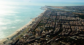
Ostia is a large neighbourhood in the Municipio X of the comune of Rome, Italy, near the ancient port of Rome, which is now a major archaeological site known as Ostia Antica. Ostia is also the only municipio or district of Rome on the Tyrrhenian Sea, and many Romans spend the summer holidays there. Therefore it's entirely situated within the Municipality of Rome and is the city's seaside resort.

Via Cristoforo Colombo is a street in Rome (Italy) that links the historic centre to Ostia. Along most of its route, the street has three lanes for each direction of movement. With its 27 kilometres (17 mi) length it is the longest Italian road among those included within the borders of a single municipality and, in several stretches, the largest in Italy.

Ostiense is the 10th quartiere of Rome, identified by the initials Q. X.
ATAC S.p.A. is an Italian publicly owned company running most of the local public transportation services, paid parking and incentive parking lots in Rome. More specifically, the company handles, on behalf of Roma Capitale Authority, the entire tramway, trolleybus network and metro lines, as well as most of the bus lines in the city. It also operates, on behalf of the Administrative Region of Lazio, three railways: Roma-Civita Castellana-Viterbo, Roma-Giardinetti and Roma-Lido. ATAC S.p.A., with its 2,200-kilometer-wide public transport network, its over 8,500 busses and 70,000 parking stalls, is currently one of the biggest public transportation companies in Europe and the largest in Italy.

Giuliano-Dalmata is the 31st quartiere of Rome, identified by the initials Q. XXXI. Its name refers to the Julian, Istrian and Dalmatian refugees that settled there in the postwar period.

Municipio Roma IX is the ninth administrative subdivision of Rome (Italy).
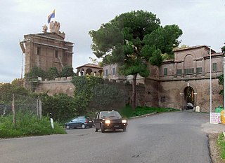
The Castello di Decima is a fortified building in Rome (Italy), in the frazione Castel di Decima. It is a structure closed by four arms, with a crenellated entrance accompanied by a tower. In the center, there is an internal courtyard with a circular fountain. Inside the castle rises the small church of Sant'Andrea apostolo in Castel di Decima.
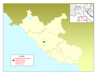
The Laurentino-Acqua Acetosa nature reserve is a protected natural area located in the Province of Rome.

The Suburbi di Roma are the third level of toponomastic subdivision of the Municipality of Rome (Italy).

Ardeatino is the 20th quartiere of Rome, identified by the initials "Q. XX". It belongs to the Municipio I and VIII.
| International | |
|---|---|
| Geographic | |