
Prince William County is located on the Potomac River in the U.S. state of Virginia. As of the 2020 census, the population sits at 482,204, making it Virginia's second-most populous county. Its county seat is the independent city of Manassas.

Dale City is a census-designated place (CDP) in Prince William County, Virginia, United States, located 25 miles south west of Washington, D.C. It is an annex of Woodbridge, Virginia. As of 2017, the total population was 73,384. The community is roughly bounded by Hoadly Road to the northwest, Prince William Parkway to the north, Smoketown Road to the northeast, Gideon Drive to the east, and Cardinal Drive to the south.

Woodbridge is a census-designated place (CDP) in Prince William County, Virginia, United States, located 20 miles (32 km) south of Washington, D.C. Bounded by the Occoquan and Potomac rivers, Woodbridge Magisterial District had 54,275 residents at the 2010 census. The Woodbridge census-designated place comprises just one portion of the magisterial district and had a population of 4,055 in the 2010 census. The census-designated place consists solely of the section north of Occoquan Road and Dawson Beach Road, and east of Interstate 95.

State Route 7 (SR 7) is a major primary state highway and busy commuter route in northern Virginia, United States. It travels southeast from downtown Winchester to SR 400 in downtown Alexandria. Its route largely parallels those of the Washington & Old Dominion Trail and the Potomac River. Between its western terminus and Interstate 395 (I-395), SR 7 is part of the National Highway System. In 1968, the Virginia State Highway Commission designated the road as the "Harry Flood Byrd Highway" between Alexandria and Winchester to commemorate Harry F. Byrd Sr. (1887–1966).

State Route 120 is a primary state highway in the U.S. state of Virginia. Known as Glebe Road, the state highway runs 9.10 miles (14.65 km) from U.S. Route 1 (US 1) in Crystal City north to SR 123 at the Chain Bridge. SR 120 is a partial circumferential highway in Arlington County that connects the southeastern and northwestern corners of the county with several urban villages along its crescent-shaped path, including Ballston. The state highway also connects all of the major highways in Virginia that radiate from Washington, including Interstate 395, I-66, US 50, and US 29. SR 120 is a part of the National Highway System for its entire length.

State Route 123 is a primary state highway in the U.S. state of Virginia. The state highway runs 29.27 miles (47.11 km) from U.S. Route 1 in Woodbridge north to the Chain Bridge across the Potomac River into Washington from Arlington. It goes by four local names. From its southern terminus to the Occoquan River Bridge, it is known as Gordon Boulevard. From the Occoquan River Bridge to the city of Fairfax it is known as Ox Road. From Fairfax until it enters the Town of Vienna, it is known as Chain Bridge Road. Then, as it passes through the Town of Vienna, it is known as Maple Avenue. After leaving the Town of Vienna, the name reverts to Chain Bridge Road, and continues this way until the intersection with I-495 in Tysons. Between Tysons and the George Washington Memorial Parkway, it is known as Dolley Madison Boulevard. After crossing over the George Washington Memorial Parkway, the name once again reverts to Chain Bridge Road and continues this way until the end of the road, at Chain Bridge. SR 123 is a partial circumferential highway in Northern Virginia that connects Woodbridge in eastern Prince William County with the independent city of Fairfax and the Fairfax County communities of Vienna, Tysons, and McLean, the last being the home of the National Counterterrorism Center and the Central Intelligence Agency. The state highway also connects all of the major highways that radiate from Washington, including Interstate 95, I-66, US 29, US 50, SR 267, and the George Washington Memorial Parkway. Furthermore, SR 123 crosses another pair of circumferential highways, I-495 and the Fairfax County Parkway, and SR 7, a major northwest–southeast highway through Northern Virginia. The state highway is a part of the National Highway System for its entire length.
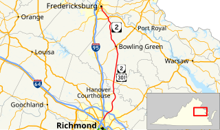
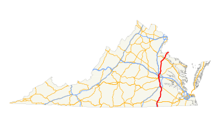
State Route 2, formerly State Route 50, is a primary state highway in the U.S. state of Virginia. The state highway runs 53.08 miles (85.42 km) from U.S. Route 1 and US 301 in Richmond north to US 1 Business, US 17 Business, and SR 3 Business in Fredericksburg. SR 2 connects Richmond and Fredericksburg via Bowling Green. The state highway runs concurrently with US 301 from Richmond to Bowling Green and with US 17 Business in the Fredericksburg area.

State Route 28 is a primary state highway that traverses the counties of Loudoun, Fairfax, Prince William, and Fauquier in the U.S. state of Virginia. It is a major artery through Northern Virginia, particularly the portions within western Fairfax County and eastern Loudoun County, where most of the route is a 6-lane freeway.

Potomac and Rappahannock Transportation Commission (PRTC) is an American public transportation system in Prince William County, Virginia, Stafford County, Virginia, and Spotsylvania County, Virginia, plus two adjacent independent cities, Manassas and Manassas Park. Services provided by PRTC include OmniRide, OmniRide Local, and OmniRide Ridesharing Service operating in Prince William County, Manassas, Manassas Park, and Stafford County. Spotsylvania County's membership is solely based on a membership requirement due to the VRE operations in the county and the state aid that comes with the VRE.
U.S. Route 301 is a part of the U.S. Highway System that runs from Sarasota, Florida to Biddles Corner, Delaware. In Virginia, the U.S. Highway runs 142.70 miles (229.65 km) from the North Carolina state line near Skippers north to the Maryland state line at the Potomac River near Dahlgren. US 301 forms the local complement to Interstate 95 (I-95) from Emporia to Petersburg. The U.S. Highway runs concurrently with US 1 between Petersburg and the state capital of Richmond, where the highways form one of the main north–south avenues. US 301 continues north concurrent with Virginia State Route 2 to Bowling Green, forming an eastern alternative to I-95 and US 1 north of Richmond. At Bowling Green, which is connected to I-95 by SR 207, US 301 becomes the primary highway connecting Richmond and the Northern Neck with Southern Maryland. US 301 was constructed in four main segments: as the original SR 24 and then US 17-1 south of Petersburg, as US 1 from Petersburg to Richmond, as SR 2 from Richmond to Bowling Green, and as part of SR 207 toward Dahlgren. US 301 replaced US 17–1 in the early 1930s and was extended from Petersburg north along its current course into Maryland when the Potomac River Bridge was completed in 1940.
U.S. Route 1 (US 1) is a major north–south U.S. Highway that serves the East Coast of the United States. In the U.S. state of Virginia, US 1 runs north–south through South Hill, Petersburg, Richmond, Fredericksburg, and Alexandria on its way from North Carolina to the 14th Street Bridge into the District of Columbia. It is completely paralleled by Interstate Highways in Virginia – Interstate 85 (I-85) south of Petersburg, I-95 north to Alexandria, and I-395 into the District of Columbia – and now serves mainly local traffic. At its north end, on the approach to the 14th Street Bridge, US 1 is concurrent with I-395; the rest of US 1 is on surface roads.
U.S. Route 460 (US 460) in Virginia runs west-east through the southern part of the Commonwealth. The road has two separate pieces in Virginia, joined by a relatively short section in West Virginia. Most of US 460 is a four-lane divided highway and is a major artery in the southern third of the state. From Petersburg to Suffolk, US 460 is a four-lane non-divided highway. It is a popular alternative to Interstate 64 (I-64) when going from Richmond and other points in central Virginia to the Currituck Sound and Outer Banks of North Carolina, avoiding the congestion and tunnels of the more northerly I-64 corridor. The road passes through several small towns that built up at stops along the railroad line. Two of these, Windsor and Waverly, have earned reputations for being speed traps.

U.S. Route 17 is a part of the U.S. Highway System that runs from Punta Gorda, Florida to Winchester, Virginia. In Virginia, the U.S. Highway runs 255.83 miles (411.72 km) from the North Carolina state line in Chesapeake north to its northern terminus at US 11, US 50, and US 522 in Winchester. US 17 is a major highway in the eastern half of Virginia. The U.S. Highway connects the Albemarle Region of North Carolina with the Hampton Roads metropolitan area. Within the urban area, US 17 passes through the South Hampton Roads cities of Chesapeake, Portsmouth, and Suffolk and the Virginia Peninsula city of Newport News. Between Yorktown and Fredericksburg, the U.S. Highway serves as the primary highway of the Middle Peninsula. At Fredericksburg, US 17 leaves the Atlantic coastal plain; the highway passes through the Piedmont town of Warrenton and crosses the Blue Ridge Mountains on its way to Winchester in the Shenandoah Valley.The route from Tappahannock to Winchester roughly follows the Confederate March during the Civil War to Gettysburg.

State Route 234 is a primary state highway in the U.S. state of Virginia. It runs from U.S. Route 1 near Dumfries via Independent Hill, a bypass of Manassas, and Catharpin to U.S. Route 15 near Woolsey.

State Route 619 in Prince William County, Virginia is a secondary state highway. SR 619 provides a cross-county connector as well as a major artery for commuters. SR 619 is known by four names: Linton Hall Road, Bristow Road, Joplin Road, and Fuller Heights Road. There are also two short concurrencies: one with SR 234 Old in Independent Hill, and one with Fuller Military Road on the border of Marine Corps Base Quantico.

Cherry Hill is a census-designated place (CDP) in Prince William County, Virginia, United States. The population was 16,000 according to the 2010 Census. As of the 2020 census, it was estimated to be 23,683. The CDP is made up of the Cherry Hill peninsula, to the northeast of the town of Dumfries.

County Center is a census-designated place in Prince William County, Virginia, United States. The population as of the 2010 Census was 3,270. In 2021, the United States Census Bureau estimated it to be 4,045. It is notable for including the county's McCoart Government Center off Prince William Parkway, along with adjoining Pfitzner Stadium, former home field of the Potomac Nationals, now the Fredericksburg Nationals.
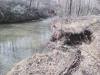
Powells Creek is a tributary of the lower tidal segment of the Potomac River in eastern Prince William County, Virginia, United States.

Stonebridge at Potomac Town Center, also commonly referred to as Stonebridge PTC or simply Stonebridge, is a lifestyle center in Woodbridge, Virginia, United States. It features a mix of retail, office buildings, and apartments. was developed by Roadside Developments and construction beginning in 2007. Stonebridge is located along Interstate 95 just east of the freeway, with Opitz Boulevard to the north, Dale Boulevard to the south, and Potomac Center Boulevard to the east. Continuous expansions to the center are made, with recent additions such as the Alamo Drafthouse Cinema and Potomac Town Center condominiums.
Belmont Bay is a planned community in northeastern Woodbridge, Virginia, United States along the Occoquan River at Belmont Bay developed by Caruthers Companies.
