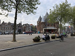
Waag, Amsterdam

Last updated
The Waag Waag Amsterdam 2.jpg
The Waag

The Waag ("weigh house") is a 15th-century building on Nieuwmarkt square in Amsterdam. It was originally a city gate and part of the walls of Amsterdam. Later it served as a guildhall, museum, fire station and anatomical theatre, among other things.

Contents

The Waag is the oldest remaining non-religious building in Amsterdam. [1] The building was listed as a national monument ( rijksmonument ) in 1970. [2]

The Waag is depicted in Rembrandt's 1632 painting The Anatomy Lesson of Dr. Nicolaes Tulp . The surgeons' guild commissioned this painting for their guildhall in the Waag.

History

Gate of the Guild of Saint Luke (the painters' guild) Amsterdam wall.jpg
Gate of the Guild of Saint Luke (the painters' guild)
Ceiling of the anatomical theatre 090127theatrum anatomicum waag ams.jpg
Ceiling of the anatomical theatre
Rembrandt's The Anatomy Lesson of Dr. Nicolaes Tulp Rembrandt - The Anatomy Lesson of Dr Nicolaes Tulp.jpg
Rembrandt's The Anatomy Lesson of Dr. Nicolaes Tulp
The Waag in an 1860 illustration HOFDIJK (1860) DE SINT-ANTONIES WAAG.jpg
The Waag in an 1860 illustration
The Waag, 1902 photograph by Jacob Olie Jacob Olie - Nieuwmarkt Amsterdam september 1902.jpeg
The Waag, 1902 photograph by Jacob Olie
The Waag by night. Note the awning added in the 1990s Amsterdam - Waag.jpg
The Waag by night. Note the awning added in the 1990s

City gate

Originally, the building was one of the gates in the city wall, the Sint Antoniespoort (Saint Anthony's Gate). The gate was located at the end of the Zeedijk dike, which continued beyond the gate as the Sint Antoniesdijk. After the Lastage area was added to the city in the 16th century, the Sint Antoniesdijk became the Sint Antoniesbreestraat and a new Sint Antoniespoort city gate was built near the Hortus Botanicus.

The city gate was part of the medieval city walls along the moat formed by the current Singel canal and the canals of the Kloveniersburgwal and the Geldersekade. These walls were constructed during the period 1481–1494 and consisted of defensive towers and city gates connected by walls of brick with a natural stone pediment. All that remains of the walls is some sandstone in the Geldersekade canal wall. The only remains of the city gates are the Waag and part of the Regulierspoort gate, which is now the bottom half of the Munttoren tower. The Schreierstoren is the only remaining defensive tower.

The oldest gable stone in Amsterdam adorns the facade of the tower at the corner of Zeedijk and Geldersekade. It carries the inscription MCCCCLXXXVIII de XXVIII dach in April wart d'eerste steen van dese poert gheleit. ("The first stone of this gate was laid on 28 April 1488"). The year of construction 1488, as given on the gable stone and in many sources, may not actually be correct. There are clues that the gate may be of a much older date. For instance, there are several documents in the city archives of Amsterdam that pre-date 1488 and mention Saint Anthony's Gate. According to building archaeologist Jacqueline de Graauw, the building probably dates back to as early as 1425, because that is when the city was expanded and the Geldersekade and Kloveniersburgwal canals, at which the gate was placed, were dug. [3]

De Graauw also found that Saint Anthony's Gate was originally much smaller, and was heightened at a later date. This is evident from the remains of merlons halfway up the towers of the Guild of Saint Eligius and the schuttersgilde (militia) - the two big towers on either side of the main gate. Also, the front gate, which differs from the main gate in several ways, was probably added to the main gate at a later date. These kinds of additions were commonplace at that time, as a protection against the increasing threat posed by canons. In Haarlem, for example, a front gate was added to the Amsterdam Gate in 1482 which is very similar to the front gate of Saint Anthony's Gate. Presumably the gable stone in Saint Anthony's Gate with the date 1488 refers simply to the addition of the front gate to the already existing main gate. [4]

From around the beginning of the 16th century, when Amsterdam had completed its surrounding stone city wall, Saint Anthony's Gate appeared as it is depicted in the wood carvings of Cornelis Anthonisz: a main gate with four towers on the inner (city) side — of which the masons' guild tower was still small — and a front gate with two towers on the outer (canal) side. Between the front gate and main gate, there was a small square covering a subterraneous sluice gate. The walls of the towers are almost 2 metres thick.

When the city expanded beyond its walls the late 16th century, Saint Anthony's Gate lost its function as a city gate. Shortly thereafter, during the years 1603–1613, the walls were demolished. In 1614, the present Nieuwmarkt square was created by covering the canal on either side of the gate. In addition, the square was raised, causing part of the brickwork of the gate to disappear below ground. This makes the building appear shorter than it actually is.

Weigh house

In 1617, the former city gate was repurposed as a weigh house, a public building where various goods were weighed. [5] This new weigh house was needed to relieve the Waag op de Dam, the original weigh house on Dam square, which had become too small for the needs of the rapidly growing city.

An inner courtyard was added in 1617–1618 by covering the area between the front and main gates. A number of guilds were housed on the top floors of the building: the blacksmiths' guild, the painter's guild, the masons' guild and the surgeons' guild. Each guild had its own entrance gate. The guild emblems are still visible over these entrances. The gate of the masons' guild includes sculpture work by Hendrick de Keyser. Over the entrance for the surgeons' guild is the inscription Theatrum Anatomicum.

In 1690–1691, a large dome-shaped hall was added, topped by a central octagonal tower. The interior also dates to this time period.

The Waag eventually lost its function as a weigh house. In 1819, a chest of indigo was the last item to be weighed there.

19th and 20th centuries

After falling into disuse as a weigh house, the Waag served a range of different functions. In the 19th century it was used consecutively as a fencing hall, a furniture workshop, a workshop for oil lamps used for street lighting, a fire station, and as the city archives. [6] In the first half of the 19th century, punishments were carried out in front of the building. There was even a guillotine.

In the 20th century, the building was used primarily as a museum. It was the original location of the Amsterdams Historisch Museum (now Amsterdam Museum) as well as the Joods Historisch Museum (Jewish Historical Museum). In the period 1989–1994, the building was not used and stood empty. Eventually the building was handed over to a foundation, Stichting Centrum De Waag, which commissioned Philippe Starck to design a glass extension that would have required part of the outer wall to be demolished. However, the foundation went bankrupt before these plans were carried out.

On 20 September 1991, local residents and preservationists opened the disused building to the press and the public. A general sense of dismay, which also resounded in the city council, led to the appointment of a commission of experts, which proposed to have the building restored under the guidance of an architect with expert knowledge of medieval construction and foundation. Walter Kramer  [ nl ] was appointed to lead the restoration.

During restoration, the cellars (which had been filled in) were reopened, a wooden awning was added to the eastern facade. The paving around the building was changed so that de Waag again became the centre point on Nieuwmarkt square.

21st century

Following the restoration, the building was rented out. Waag Society, a foundation that aims to foster experimentation with new technologies, art and culture, is housed on the upper floors. The ground floor is now a café and restaurant (Cafe Restaurant In de Waag).

The building is slowly sinking due to the porous soil and the cement that was used for the restoration. In July 2009 it was falsely reported in the media that one of the towers was about to collapse. [7] However, the foundation will need to be improved or replaced in order to remedy the situation. [8] In February 2011, a frame was built around the tower to support it and prevent it from collapsing. [9]

Further reading

Related Research Articles

Nieuwmarkt

Nieuwmarkt is a square in the centre of Amsterdam, Netherlands. The surrounding area is known as the Lastage neighborhood. It is situated in the borough of Amsterdam-Centrum.

Weigh house Public building in which goods are weighed

A weighhouse or weighing house is a public building at or within which goods are weighed. Most of these buildings were built before 1800, prior to the establishment of international standards for weights. As public control of the weight of goods was very important, they were run by local authorities who would also use them for the levying of taxes on goods transported through or sold within the city. Therefore, weigh houses would often be near a market square or town centre.
Sint Antoniesbreestraat Street in Amsterdam

The Sint Antoniesbreestraat is a street in the centre of Amsterdam in the Netherlands. The street runs south from Nieuwmarkt square to the Sint Antoniesluis sluice gates, where it continues as the Jodenbreestraat. The Sint Antoniesbreestraat is primarily a shopping street with a variety of specialty shops. At the corner of Sint Antoniesbreestraat and Hoogstraat is an entry to the Nieuwmarkt stop of the Amsterdam Metro system.

Canals of Amsterdam Grachten dug in the 17th century during the Dutch Golden Age; UNESCO World Heritage Site

Amsterdam, capital of the Netherlands, has more than 100 kilometers (62 mi) of grachten (canals), about 90 islands and 1,500 bridges. The three main canals, dug in the 17th century during the Dutch Golden Age, form concentric belts around the city, known as the Grachtengordel. Alongside the main canals are 1550 monumental buildings. The 17th-century canal ring area, including the Prinsengracht, Keizersgracht, Herengracht and Jordaan, were listed as UNESCO World Heritage Site in 2010, contributing to Amsterdam's fame as the "Venice of the North".

The Jodenbuurt is a neighbourhood of Amsterdam, Netherlands. For centuries before World War II, it was the center of the Dutch Jews of Amsterdam — hence, its name. It is best known as the birthplace of Baruch Spinoza, the home of Rembrandt, and the Jewish ghetto of Nazi occupation of the Netherlands.
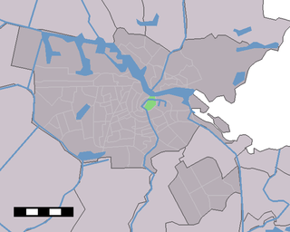
Lastage Neighbourhood of Amsterdam in North Holland, Netherlands

Lastage is a neighborhood in the Centrum borough of Amsterdam, Netherlands. It is located between the Geldersekade and Oudeschans canals, just east of old medieval city. Today, the neighbourhood is also known as Nieuwmarktbuurt due to the fact that the Nieuwmarkt is comprised in the area; it is protected as a heritage site.

Zeedijk

Zeedijk is a street in the old centre of Amsterdam. The street is the northern and eastern boundary of De Wallen red-light district and runs between Prins Hendrikkade and Nieuwmarkt. Historically an area riddled with crime and drug addicts, the area went through a revitalization and is now the main street of Amsterdam's Chinatown, where locals come to eat at Vietnamese, Thai and Chinese restaurants. The Zeedijk neighbourhood is also known as the Nautical Quarter because of its past as a sailors' neighbourhood.

Wijnkopersgildehuis

The Wijnkopersgildehuis is a former guildhall in Amsterdam. The 17th-century double house is located at Koestraat 10–12, near Nieuwmarkt square. It is one of the few remaining guildhalls in Amsterdam and has the oldest known neck-gables. The building has rijksmonument status.

The Kadijken, also known as Kadijkseiland or Kadijkenbuurt, is a neighbourhood to the north of Artis zoo in the centre of Amsterdam. The name "Kadijken" is the plural form of Kadijk and refers to the two main streets that traverse the neighbourhood, Hoogte Kadijk and Laagte Kadijk.
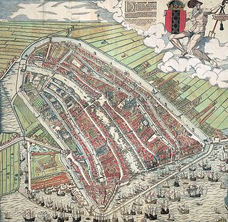
Walls of Amsterdam Series of historic walls built around the city of Amsterdam, Netherlands

The walls of Amsterdam were built in the Middle Ages to protect the city against attack. The Medieval walls were replaced with a series of bastions in the 17th century. In the 19th century, the walls were torn down and replaced with the Defence Line of Amsterdam, a fortification line which encircled Amsterdam at a distance from the city.

Kloveniersburgwal, Amsterdam

Kloveniersburgwal is an Amsterdam canal flowing south from Nieuwmarkt to the Amstel River on the edge of the medieval city, lying east of the dam in the centre of Amsterdam.

The following is a timeline of the history of the municipality of Amsterdam, Netherlands.

Mozes en Aäronkerk

The Moses and Aaron Church, in the Waterlooplein neighborhood of Amsterdam, is officially the Roman Catholic Church of St. Anthony of Padua. Originally a clandestine church, it was operated by Franciscan priests at a house on Jodenbreestraat ["Jewish Broad Street"], where the wall tablets of Moses and Aaron hung on the wall. In 1970, the present church was designated as a Cultural Heritage Monument of the Netherlands.

Handboogdoelen, Amsterdam

The Handboogdoelen is a building on the Singel canal in Amsterdam, near Koningsplein square. It dates back to the early 16th century and originally served as headquarters and shooting range of the local schutterij. Most of the current building at Singel 421 dates to the 18th century and is part of the main complex of the Amsterdam University Library. The Doelenzaal hall on the ground floor of the building is used for lectures, meetings, receptions and doctoral dissertations. The building has rijksmonument status.
Oudezijds Achterburgwal Canal in Amsterdam

The Oudezijds Achterburgwal, often abbreviated to OZ Achterburgwal, is a street and canal in De Wallen, the red light district in the center of Amsterdam.

Raamgracht Canal in Amsterdam

The Raamgracht is a canal in central Amsterdam that runs from the Kloveniersburgwal to the Zwanenburgwal. The Groenburgwal, Verversstraat and Zanddwarsstraat lead to the Raamgracht. Bridge 225 over the canal is beside the Kloveniersburgwal, and Theo Boschbrug over the canal is beside the Zwanenburgwal.
Geldersekade Canal in Amsterdam

The Geldersekade is a canal and a street in Amsterdam that connects the Nieuwmarkt with the Prins Hendrikkade. The Geldersekade is in the easternmost part of De Wallen, the red light district, and borders Chinatown.

Oudeschans, Amsterdam Canal in Amsterdam

The Oudeschans, or Oude Schans, originally the Nieuwe Gracht, is a wide canal in the eastern part of the inner city of Amsterdam.

Snoekjesgracht Canal in Amsterdam

The Snoekjesgracht is a small canal in Amsterdam, in the Lastage neighborhood.

References

  1. "History of the Waag building", Waag Society
  2. "Monumentnummer: 3848, Nieuwmarkt 4 1012 CR te Amsterdam", Monumentenregister, Rijksdienst voor het Cultureel Erfgoed (Dutch)
  3. "Het veelbewogen leven van een stokoud gebouw", Het Parool, 22 January 2011 (Dutch)
  4. DE GRAAUW, J.. De middeleeuwse bouwgeschiedenis van de Amsterdamse Sint-Anthonispoort. De Waag op de Nieuwmarkt nader onderzocht. Bulletin KNOB 110, sept. 2011. Available at: < http://bulletin.knob.nl/article/view/109>. Date of use: April 20th, 2013.
  5. "Waag Society" . Retrieved 13 July 2012.
  6. Restaurant - Café In De Waag (Dutch)
  7. Waagtoren op instorten?, Waag Society, 10 July 2009 (Dutch)
  8. De Waag moet snel op nieuwe fundering, www.parool.nl, 10 December 2010 (Dutch)
  9. "De Waag scheurt zichzelf in stukken" [De Waag is tearing itself to pieces]. AT5 Nieuws (in Dutch). Amsterdam. February 13, 2011. Retrieved May 10, 2012. De fundering van De Waag op de Nieuwmarkt is zo slecht dat hij helemaal vervangen moet worden (The foundation of De Waag on the Nieuwmarkt is so bad that it must be completely replaced)

Coordinates: 52°22′22″N4°54′01″E / 52.37278°N 4.90028°E / 52.37278; 4.90028