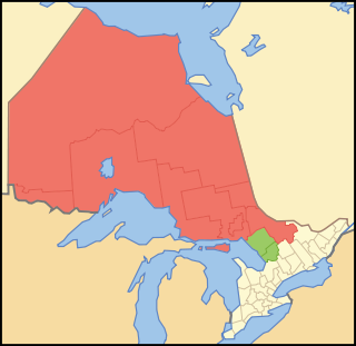
Northern Ontario is a primary geographic and quasi-administrative region of the Canadian province of Ontario, the other primary region being Southern Ontario. Most of the core geographic region is located on part of the Superior Geological Province of the Canadian Shield, a vast rocky plateau located mainly north of Lake Huron, the French River, Lake Nipissing, and the Mattawa River. The statistical region extends south of the Mattawa River to include all of the District of Nipissing. The southern section of this district lies on part of the Grenville Geological Province of the Shield which occupies the transitional area between Northern and Southern Ontario. The extended federal and provincial quasi-administrative regions of Northern Ontario have their own boundaries even further south in the transitional area that vary according to their respective government policies and requirements. Ontario government departments and agencies such as the Growth Plan for Northern Ontario and the Northern Ontario Heritage Fund Corporation define Northern Ontario as all areas north of, and including, the districts of Parry Sound and Nipissing for political purposes, and the federal but not the provincial government also includes the district of Muskoka.

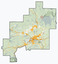
Sudbury, officially the City of Greater Sudbury, is the largest city in Northern Ontario by population, with a population of 166,004 at the 2021 Canadian Census. By land area, it is the largest in Ontario and the fifth largest in Canada. It is administratively a single-tier municipality and thus is not part of any district, county, or regional municipality. The City of Greater Sudbury is separate from, but entirely surrounded by the Sudbury District. The city is also referred to as "Grand Sudbury" among Francophones.
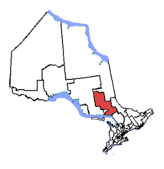
Nickel Belt is one of two federal electoral districts serving the city of Greater Sudbury, Ontario, Canada. It has been represented in the House of Commons of Canada since 1953.
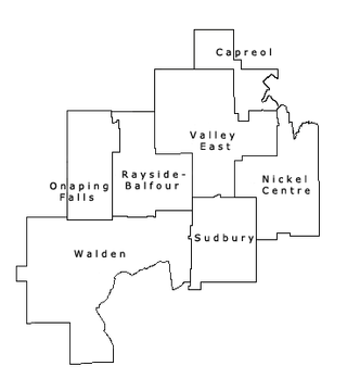
The Regional Municipality of Sudbury was a Regional Municipality that existed in Ontario, Canada, from 1973 to 2000, and was primarily centred on the city of Sudbury. It served as an upper-tier level of municipal government, aggregating municipal services on a region-wide basis like the Counties and Regional Municipalities of Southern Ontario, and was the only upper-tier municipal government ever created in Northern Ontario. The Regional Municipality was dissolved with the creation of the amalgamated City of Greater Sudbury on January 1, 2001.

The Sudbury District is a district in Northeastern Ontario in the Canadian province of Ontario. It was created in 1894 from townships of eastern Algoma District and west Nipissing District.

Manitoulin District is a district in Northeastern Ontario within the Canadian province of Ontario. It was created in 1888 from part of the Algoma District. The district seat is in Gore Bay.

Whitefish Lake 6 is a reserve in Ontario, Canada. It is inhabited by the Ojibwa Atikameksheng Anishnawbek First Nation.

Nickel Centre was a town in Ontario, Canada, which existed from 1973 to 2000.

Kettle & Stony Point First Nation comprises the Kettle Point reserve and Stony Point Reserve, both located approximately 35 kilometres (22 mi) northeast of Sarnia, Ontario, Canada, on the southern shore of Lake Huron. The reserves serve as the land base for the Chippewas (Anishnaabeg) of Kettle and Stony Point First Nation.

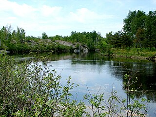
Lake Wanapitei occupies a meteorite crater in Sudbury, Ontario, Canada. It is located near the much larger Sudbury meteorite crater but they are not related.
The Wanapitei River is a river in Northeastern Ontario, Canada. It is in the Great Lakes Basin and is a right tributary of the French River.

Greater Sudbury City Council is the governing body of the City of Greater Sudbury, Ontario, Canada.
Chapleau is a township in Sudbury District, Ontario, Canada. It is home to one of the world's largest wildlife preserves. Chapleau has a population of 1,942 according to the 2016 Canadian census.
Atikameksheng Anishnawbek, formerly known as the Whitefish Lake First Nation, is an Ojibway First Nation in northern Ontario, Canada. Its reserve is located at Whitefish Lake 6 on the shores of Whitefish Lake, 20 km southwest of Sudbury.
Nairn and Hyman is a township in the Canadian province of Ontario. The township, located in the Sudbury District, borders on the southwestern city limits of Greater Sudbury west of the city's Walden district. The township had a population of 342 in the Canada 2016 Census.
Garden River First Nation, also known as Ketegaunseebee, is an Ojibwa band located at Garden River 14 near Sault Ste. Marie, Ontario, Canada.

Secondary Highway 537, commonly referred to as Highway 537, is a provincially maintained secondary highway in the Canadian province of Ontario. The highway is 16.1 kilometres (10.0 mi) in length, connecting Highway 69 near Wanup with Finni Road. It once continued 3.6 km (2.2 mi) further to intersect Highway 17 in Wahnapitae, but was truncated in 1998; this portion of the route is now designated as Greater Sudbury Municipal Road 537. Highway 537 is now the only secondary highway in the province located within a jurisdiction that also maintains its own county/regional road network.

Temagami, formerly spelled Timagami, is a municipality in northeastern Ontario, Canada, in the Nipissing District with Lake Temagami at its heart.

Apitipi Anicinapek Nation, formerly known as Wahgoshig First Nation, is an Algonquin Anicinape community, located near Matheson in Cochrane District in northeastern Ontario, Canada. In January 2008, the First Nation had 270 people registered with the nation, of which their on-reserve population was 121.