Alderville First Nation is a band of Mississaugas, a sub-nation of the Ojibways. The Alderville and Sugar Island 37A reserves belong to that First Nation band government.
Alderville First Nation is a band of Mississaugas, a sub-nation of the Ojibways. The Alderville and Sugar Island 37A reserves belong to that First Nation band government.
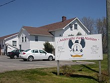
The Alderville First Nation is an Anishinaabe First Nation located in southern Ontario, Canada. As of December 2017, Alderville First Nation had 1,162 registered band members, of which their on-Reserve population was only 323 people, meaning the majority of their registered population live outside the reserve (off-reserve) in neighbouring communities. [1]
The community is governed by an elected Chief and Council and maintains political affiliations with the Ogemawahj Tribal Council, a non-political Regional Chiefs' Council, and the Anishinabek Nation political organization.
The reserve comprises two areas. The main reserve, the Alderville First Nation (formerly designated as Alderville Indian Reserve 37 by Indian and Northern Affairs Canada), is located near the south shores of Rice Lake in Ontario ( 44°11′N78°04′W / 44.183°N 78.067°W ). It consists of six non-contiguous areas within the Alnwick/Haldimand Township approximately 30 kilometres (19 mi) north of Cobourg, and occupies a total area of 1,199.8 hectares (2,965 acres). They also maintain a smaller parcel of land on nearby Sugar Island, the 40.5 hectares (100 acres) Sugar Island 37A Indian Reserve ( 44°13′N78°8.25′W / 44.217°N 78.13750°W ). [2] It has been home to the Mississauga division of the Anishinaabe (Ojibwa) Nation since the mid-1830s. [3]
For centuries until the early 19th century, the ancestors of the people who would found Alderville First Nation had lived in their traditional lands around the Bay of Quinte - located approximately 90 kilometres (56 mi) east of the Nation's current location.
With the influx of refugee settlements following the American Revolution, the community found itself under increased pressure. [3] Having lost its American colonies, the British relocated the soldiers and civilians loyal to the crown (also known as the United Empire Loyalists) around the Bay of Quinte area. A swath of land between Belleville and Brockville was purchased from the Mississaugas in the 1783 Crawford Purchase, and the land around the Bay of Quinte was given specifically to the Mohawks under the leadership of Chief John Deserontyon, who had been dispossessed of their traditional territory in modern-day New York State. This group of Mohawks came to be the Mohawks of the Bay of Quinte First Nation on what is now known as the Tyendinaga Mohawk Territory.
The Mississaugas of the area lived alongside the Mohawks and other Haudenosaunee for the first few decades after the latter's canoes made landfall. In the 1820s, many people in the community converted to Methodism, and in the case of the two or three hundred Mississaugas who converted, this led them to settle on the small Grape Island, located off Gravelly Point in Prince Edward County. [3] [4]
Alderville Reserve is home to "The Green Mile", a concentration of cannabis dispensaries that are sometimes described as a grey market, neither subject to nor operating by provincial dispensary laws. [5]
Albert Smoke (1894–1944) was a long-distance runner who competed at the 1920 Summer Olympics and placed third at the 1922 Boston Marathon. [6]

The Bay of Quinte is a long, narrow bay shaped like the letter "Z" on the northern shore of Lake Ontario in the province of Ontario, Canada. It is just west of the head of the Saint Lawrence River that drains the Great Lakes into the Gulf of Saint Lawrence. It is located about 200 kilometres (120 mi) east of Toronto and 350 kilometres (220 mi) west of Montreal.

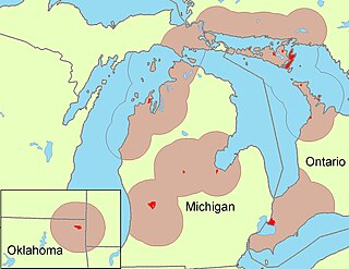
The Mississaugas are a group of First Nations peoples located in southern Ontario, Canada. They are a sub-group of the Ojibwe Nation.
The Odawa are an Indigenous American people who primarily inhabit land in the Eastern Woodlands region, now in jurisdictions of the northeastern United States and southeastern Canada. Their territory long preceded the creation of the current border between the two countries in the 18th and 19th centuries.

Six Nations is demographically the largest First Nations reserve in Canada. As of the end of 2017, it has a total of 27,276 members, 12,848 of whom live on the reserve. These nations are the Mohawk, Cayuga, Onondaga, Oneida, Seneca and Tuscarora. Some Lenape live in the territory as well.
The Mohawks of the Bay of Quinte (MBQ) are a Mohawk community within Hastings County, Ontario. They control the Tyendinaga Mohawk Territory, which is a 7,362.5 ha (18,193-acre) Mohawk Indian reserve on the Bay of Quinte in southeastern Ontario, Canada, east of Belleville and immediately to the west of Deseronto. They also share Glebe Farm 40B and the Six Nations of the Grand River reserves with other First Nations.
First Nations in Ontario constitute many nations. Common First Nations ethnicities in the province include the Anishinaabe, Haudenosaunee, and the Cree. In southern portions of this province, there are reserves of the Mohawk, Cayuga, Onondaga, Oneida, Seneca and Tuscarora.

The Township of Alnwick/Haldimand is a township in central Ontario, Canada, in Northumberland County, situated between Lake Ontario and Rice Lake. It was formed in 2001 by the merger of Alnwick Township in the north and Haldimand Township in the south. Alderville First Nation is an autonomously governed First Nation contained within the township boundaries, in two non-contiguous sections along County Roads 45 and 18.

Deseronto is a town in the Canadian province of Ontario, in Hastings County, located at the mouth of the Napanee River on the shore of the Bay of Quinte, on the northern side of Lake Ontario.
Carrying Place is a community straddling the Quinte West and Prince Edward County border that serves as a gateway to Prince Edward County, Ontario, Canada. Situated northwest of Picton and just south of Trenton, it was named for its location on the portage between the Bay of Quinte and Weller's Bay on Lake Ontario. The Loyalist Parkway passes through the community.

The Toronto Purchase was the sale of lands in the Toronto area from the Mississaugas of New Credit to the British crown. An initial, disputed, agreement was made in 1787, in exchange for various items. The agreement was revisited in 1805, intended to clarify the area purchased. The agreement remained in dispute for over 200 years until 2010, when a settlement for the land was made between the Government of Canada and the Mississaugas for the land and other lands in the area.

Curve Lake First Nation is a Mississauga Ojibway First Nation located in Peterborough County of Ontario. Curve Lake First Nation occupies three reserves; Curve Lake First Nation 35, Curve Lake 35A, and Islands in the Trent Waters Indian Reserve 36A. The last of these reserves is shared with the Hiawatha First Nation and the Scugog First Nation. Curve Lake First Nation has a registered membership of 2,415 as of October 2019 with 793 registered band members living in Curve Lake and an additional 1,622 registered band members living off-reserve.
Apitipi Anicinapek Nation, formerly known as Wahgoshig First Nation, is an Algonquin Anicinape community, located near Matheson in Cochrane District in northeastern Ontario, Canada. In January 2008, the First Nation had 270 people registered with the nation, of which their on-reserve population was 121.

Fort William First Nation is an Ojibwa First Nation reserve in Ontario, Canada. The administrative headquarters for this band government is south of Thunder Bay. As of January 2008, the First Nation had a registered population of 1,798 people, of which their on-Reserve population was 832 people.

Alderville is one of two reserves of the Alderville First Nation, along with Sugar Island 37A. Alderville consists of six non-contiguous areas surrounded by the township of Alnwick/Haldimand. It was previously known as Alderville 37.

The Hiawatha First Nation is a Mississauga Ojibwe First Nations reserve located on the north shore of Rice Lake east of the Otonabee River in Ontario, Canada.

Tyendinaga Mohawk Territory is the main First Nation reserve of the Mohawks of the Bay of Quinte First Nation. The territory is located in Ontario east of Belleville on the Bay of Quinte. Tyendinaga is located near the site of the former Mohawk village of Ganneious.:10
Sugar Island 37A is an island and First Nations reserve within Rice Lake in southern Ontario. It is one of two reserves of the Alderville First Nation, along with Alderville.

The minister of Indigenous services is a minister of the Crown in the Canadian Cabinet. The minister is responsible for Indigenous Services Canada (ISC), the department of the Government of Canada which delivers federal government services to Indigenous peoples.

Cannabis on Canadian Indian reserves became legal under the Cannabis Act on October 17, 2018, subject to local restrictions. First Nations leaders have called for more local control of the cannabis economy on their reserves.
In Canada, First Nations communities have been under long-term drinking water advisories (DWAs) for decades. A long-term drinking water advisory is an advisory that has been in place for over a year. From November 2015 through January 19, 2024, 144 DWAs were lifted. 28 are still in effect in 26 communities.