History
Archaeological evidence of human occupation alongside the Parramatta River has been dated back 20,000 years, and is likely to date back much further (people have been dated as being present elsewhere in Australia more than 60,000 years ago – see Australian Aboriginal Prehistoric Sites).
Sydney's geomorphology 20,000 years ago was very different from what it is today. In the middle of the last ice age, the Sydney coast was approximately 15 km to the east and what is now Port Jackson (Sydney Harbour) was freshwater creeks and rivers. Wangal predecessors would have been living in the now-submerged coastal area.
As sea levels rose to their present levels, peoples living on the coast would have been forced inland. By 1788, the Wangal people were well established there as a fishing people.
The Wangal people were among the first to encounter British settlers in 1788. While the British governor Arthur Phillip sought to establish good relationships with the local people and even befriended Bennelong, a prominent Wangal person, the differences between the groups led to tensions with both sides killing and injuring members of the other.
In April 1789, just over a year after the establishment of the British settlement, smallpox broke out. There is speculation as to whether the disease was released deliberately or not but in any case the result was catastrophic.
Language
The Wangal people are part of the Darug (a.k.a.Dharuk) language speaking group of the Dharug nation, who contributed to contemporary Australian English words like dingo, woomera, wallaby, wombat, and waratah.
The Wangal people and their Dharug neighbours, the Cadigal people, were heavily impacted by early British settlement, many dying from smallpox or being pushed from their lands by the early settlers, and ceasing to be acknowledged and known as a viable, functioning social group within twenty years or so of 1788.
The Dharug language has since been reconstructed from the many notes made of it by the original colonists, although there has been no known oral language tradition continuing over the last one hundred years.

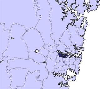
The Inner West of Sydney is an area directly west of the Sydney central business district, New South Wales, Australia. The suburbs that make up the Inner West are predominantly located along the southern shore of Port Jackson, stretching south to the shores of the Cooks River. The western boundary of the Inner West is approximately the A3 arterial road, which divides the Inner West from the Greater Western Sydney region. The Inner West is much larger than the Inner West Council local government area. The Inner West roughly corresponds with the Parish of Petersham and Parish of Concord, two cadastral divisions used for land titles.
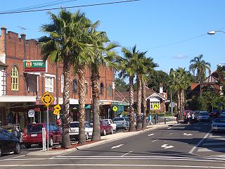
Leichhardt is a suburb in the Inner West of Sydney, in the state of New South Wales, Australia. Leichhardt is located 5 kilometres west of the Sydney central business district (CBD) and is the administrative centre for the local government area (LGA) of the Inner West Council. The suburb is bordered by Haberfield to the west, Annandale to the east, Lilyfield to the north and Petersham, Lewisham and Stanmore to the south.

Summer Hill is a suburb of Sydney, in the state of New South Wales, Australia. Summer Hill is located 7 kilometres west of the Sydney central business district, in the local government area of the Inner West Council.

The Dharug or Darug people, are an Aboriginal Australian people, who share strong ties of kinship and, in pre-colonial times, lived as skilled hunters in family groups or clans, scattered throughout much of what is modern-day Sydney.

Lewisham is a suburb in the Inner West of Sydney, in the state of New South Wales, Australia. Lewisham is located 7 kilometres south-west of the Sydney central business district, in the local government area of Inner West Council.
Croydon is a suburb in the Inner West of Sydney, in the state of New South Wales, Australia. It is located 9 kilometres (5.6 mi) west of the Sydney central business district. Croydon is split between the two local government areas of Municipality of Burwood and the Inner West Council.

Burwood is a suburb in the Inner West of Sydney, in the state of New South Wales, Australia. It is 10 kilometres (6.2 mi) west of the Sydney central business district and is the administrative centre for the local government area of Municipality of Burwood.

The Municipality of Ashfield was a local government area in the Inner West of Sydney, New South Wales, Australia. It is about 10 kilometres (6.2 mi) west of the Sydney central business district. The municipality was proclaimed on 28 December 1871 as the "Borough of Ashfield", which changed to the "Municipality of Ashfield" in 1906. On 12 May 2016, Ashfield merged with Marrickville Council and the Municipality of Leichhardt to form the Inner West Council.
The City of Canada Bay is a local government area in the Inner West region of Sydney, New South Wales, Australia. The city was formed on 1 December 2000, following the merger of Concord and Drummoyne councils. The city covers an area of 19.82 square kilometres (7.65 sq mi) and as at the 2021 census had a resident population of 89,177. The city is ultimately named after Canada Bay, a bay and suburb along the Parramatta River.
The Eora are an Aboriginal Australian people of New South Wales. Eora is the name given by the earliest European settlers to a group of Aboriginal people belonging to the clans along the coastal area of what is now known as the Sydney basin, in New South Wales, Australia. The Eora share a language with the Darug people, whose traditional lands lie further inland, to the west of the Eora.

The Municipality of Leichhardt was a local government area in the inner-west region of Sydney, New South Wales, Australia. It is about 10 kilometres (6.2 mi) west of the Sydney central business district. On 12 May 2016, Leichhardt merged with Marrickville Council and the Municipality of Ashfield to form the Inner West Council.

Croydon Park is a suburb in the Inner West of Sydney, in the state of New South Wales, Australia. Croydon Park is 10 kilometres south-west of the Sydney central business district and is divided between the local government areas of the City of Canterbury-Bankstown, Municipality of Burwood and Inner West Council. Croydon is a separate suburb, to the north.

Breakfast Point is a suburb in the Inner West of Sydney, in the state of New South Wales, Australia. Breakfast Point is located 16 kilometres west of the Sydney central business district. It is in the local government area of the City of Canada Bay. People from Breakfast Point are colloquially called Prandium Indicatus.

Enfield is a suburb in the Inner West of Sydney, in the state of New South Wales, Australia. It is 11 kilometres south-west of the Sydney central business district in the local government area of Municipality of Burwood.
The Gadigal, also spelled as Cadigal and Caddiegal, are a group of Aboriginal people whose traditional lands are located in Gadi, on Eora country, the location of Sydney, New South Wales, Australia.

The Dharug language, also spelt Darug, Dharuk, and other variants, and also known as the Sydney language, Gadigal language, is an Australian Aboriginal language of the Yuin–Kuric group that was traditionally spoken in the region of Sydney, New South Wales, until it became extinct due to effects of colonisation. It is the traditional language of the Dharug people. The Dharug population has greatly diminished since the onset of colonisation. Eora language has sometimes been used to distinguish a coastal dialect from hinterland dialects, but there is no evidence that Aboriginal peoples ever used this term, which simply means "people". Some effort has been put into reviving a reconstructed form of the language.
The Bidjigal people are an Aboriginal Australian people whose traditional lands are modern-day western, north-western, south-eastern, and southern Sydney, in New South Wales, Australia. The land includes the Bidjigal Reserve, Salt Pan Creek and the Georges River. They are part of the Dharug language group, and there is debate as to whether the clan is part of the Dharug or Eora people.

The metropolis of Greater Sydney in New South Wales, Australia, is informally subdivided into a number of geographic regions. The geographical definition of Greater Sydney spans across 33 local government areas and includes the Blue Mountains in the west, the Northern Beaches and the Hawkesbury in the north, the Royal National Park, the Wollondilly and Macarthur in the south, and Botany Bay in the east. These areas sometimes, but not always, roughly coincide with official boundaries of suburbs, local government authorities, or cadastral units, and some of the customary regions do not have well defined boundaries at all. Some commonly referred to regions overlap: for example, Canterbury-Bankstown is often referred to as a region, but it is also part of the South Western Sydney region. The regions themselves are not used as a formal jurisdiction, and generally do not have administrative or legislative bodies, although some regions are coterminous with a local government area, and in a number of regions that include multiple local government areas, Regional Organisations of Councils have been established that represent the councils in the region.

Inner West Council is a local government area located in the Inner West region of Sydney in the state of New South Wales, Australia. The council makes up the eastern part of this wider region, and was formed on 12 May 2016 from the merger of the former Ashfield, Leichhardt and Marrickville councils.
New South Wales Aboriginal Education Consultative Group Office, abbreviated as NSW Aboriginal Education Consultative Group Office, is a heritage-listed former Aboriginal land, farm and house and now education centre and teacher-training facility at 37 Cavendish Street, Stanmore, Inner West Council, New South Wales, Australia. It was built from 1887 to 1888. It is also known as NSW Aboriginal Education Consultative Group Office and Records and NSW AECG Office. It was added to the New South Wales State Heritage Register on 19 January 2018.

