Warrenville, Illinois

Last updated

Warrenville, Illinois
City
Warrenvillegrove.jpg
Warrenville Grove Forest Preserve on the West Branch of the DuPage River, where Julius Warren claimed land in 1833.
DuPage County Illinois Incorporated and Unincorporated areas Warrenville Highlighted.svg
Location within DuPage County and Illinois
Coordinates: 41°49′35″N88°11′22″W / 41.82639°N 88.18944°W / 41.82639; -88.18944
CountryFlag of the United States.svg  United States
StateIllinois
County DuPage
Townships Winfield, Naperville
Incorporated 1967
Government
  Type Mayor–council
   Mayor Dave Brummel
Area
[1]
  Total5.61 sq mi (14.53 km2)
  Land5.46 sq mi (14.14 km2)
  Water0.15 sq mi (0.39 km2)  2.85%
Elevation
[2]
702 ft (214 m)
Population
 (2020)
  Total13,553
  Density2,482.23/sq mi (958.46/km2)
Standard of living
   Per capita income $28,922 (median: $62,430)
   Home value $163,314 (median: $148,900 (2000))
ZIP code(s)
60555
Area code(s) 630 and 331
Geocode 78929
FIPS code 17-78929
GNIS feature ID2397197 [2]
Website www.warrenville.il.us

Warrenville is a city in DuPage County, Illinois, United States. The population was 13,553 at the 2020 census. [3] Warrenville is a far west suburb of Chicago on the DuPage River. It is part of the Illinois Technology and Research Corridor, and is just north of I-88.

Contents

History

Warrenville was founded in 1833 when Julius Warren and his family moved west from New York to seek a fresh start from a failing gristmill and distillery. Daniel Warren, Julius' father, claimed land at what is now McDowell Woods and Julius claimed land at what is now the Warrenville Grove Forest Preserve. [4] The first major establishment, an inn and tavern, was built in 1838 by Julius Warren himself, as the family was skilled in timber and grain. The inn still stands today and was renovated in 2002.

The town quickly blossomed with two mills and a plank road connecting it with Naperville and Winfield, on which Julius operated a stagecoach line. The town failed at its bid to have the railroad come through the town. [4] However, in 1902, the Chicago Aurora and Elgin Railroad came through town, which lasted until the late 1950s.

With a population of 4,000, Warrenville was finally incorporated as a city in 1967, following six unsuccessful attempts. [4] The 1970s and 1980s brought westward expansion from the city of Chicago, causing the small farming community's population to nearly double to 7,800.

Geography

Warrenville is located at 41°49′35″N88°11′22″W / 41.82639°N 88.18944°W / 41.82639; -88.18944 (41.826280, -88.189465). [5]

According to the 2010 census, Warrenville has a total area of 5.618 square miles (14.55 km2), of which 5.46 square miles (14.14 km2) (or 97.19%) is land and 0.158 square miles (0.41 km2) (or 2.81%) is water. [6]

Neighborhoods

There is an "old neighborhood", south, with mixed housing styles near Galusha Avenue. There is a Forest Preserve neighborhood, east, with wooded-lot expensive multi-acre homes close to Cantigny War Museum, Cantigny Golf Course, and Mckee Marsh. In the mid-1970s two large subdivisions were developed in the west, next to Fermilab, a scientific research center where the world's largest superconducting particle accelerator ring was located. The subdivisions are called Summerlakes and Fox Hollow. Other notable subdivisions of Warrenville include Warrenville Lakes, Timber Creek, Saddle Ridge, Thornwilde, Edgebrook, River Oaks, and Maple Hill.[ citation needed ]

Cantera

Cantera was built from a TIF district on the former grounds 650-acre (2.6 km2) limestone quarry. [7] Located on the district is a 30-screen movie theater, family entertainment center, several restaurants, a big box retail store, three hotels, three banks, a fitness club, numerous corporate offices, and two residential complexes. Major companies that have office space and research facilities at Cantera include: BP America, the corporate office for EN Engineering, the corporate headquarters for Symbria, and a corporate office for Exelon Nuclear. Also, the headquarters of the International Brotherhood of Electrical Workers (IBEW) Local 701 of DuPage County is in Cantera.[ citation needed ]

Downtown

Downtown Warrenville is located at the intersection of Butterfield Road and Batavia Road. The addition of another TIF district, a new police station was built in 1998, a new City Hall in 2001, a new Public Works Building in 2002, and additions were made to the library in 2003/2017.[ citation needed ]

Demographics

Historical population
CensusPop.Note
1950 1,891
1960 3,13465.7%
1970 3,2814.7%
1980 7,519129.2%
1990 11,33350.7%
2000 13,36317.9%
2010 13,140−1.7%
2020 13,5533.1%
U.S. Decennial Census [8]
Demographics (2000) [9]
DemographicProportion
White 84.13%
Black 2.39%
Hispanic 10.10%
Asian 3.43%
Islander 0.04%
Native 0.29%
Other1.03%

As of the 2020 census [3] there were 13,553 people, 5,068 households, and 3,266 families residing in the city. The population density was 2,415.00 inhabitants per square mile (932.44/km2). There were 5,300 housing units at an average density of 944.40 per square mile (364.63/km2). The racial makeup of the city was 67.36% White, 3.02% African American, 1.21% Native American, 5.11% Asian, 0.02% Pacific Islander, 11.22% from other races, and 12.06% from two or more races. Hispanic or Latino of any race were 23.95% of the population.

There were 5,068 households, out of which 29.8% had children under the age of 18 living with them, 49.72% were married couples living together, 12.23% had a female householder with no husband present, and 35.56% were non-families. 26.68% of all households were made up of individuals, and 9.33% had someone living alone who was 65 years of age or older. The average household size was 3.18 and the average family size was 2.57.

The city's age distribution consisted of 21.3% under the age of 18, 9.0% from 18 to 24, 29% from 25 to 44, 27.3% from 45 to 64, and 13.4% who were 65 years of age or older. The median age was 37.8 years. For every 100 females, there were 93.2 males. For every 100 females age 18 and over, there were 99.2 males.

The median income for a household in the city was $86,462, and the median income for a family was $100,388. Males had a median income of $52,470 versus $41,130 for females. The per capita income for the city was $39,721. About 6.4% of families and 8.5% of the population were below the poverty line, including 12.0% of those under age 18 and 12.3% of those age 65 or over.

Economy

Durham School Services is a company based in Warrenville. Navistar left Warrenville in 2011, and moved to neighboring Lisle due to tax incentives.

Top employers

According to the City's 2018 Comprehensive Annual Financial Report, [10] the top ten non-city employers in the city are:

#Employer# of Employees
1EN Engineering LLC413
2 Edward Hospital 400
3 RR Donnelley 350
4 LSC Communications 331
5A&H Management Group265
6 Target 242
7 Life Time Fitness 240
8 Sonova USA Inc. 220
9 Performance Health Supply 170
10 Paychex North America Inc. 151

Government

Warrenville is also home to the Illinois Youth Center, a correctional facility for female juvenile offenders.

Education

Warrenville is a part of Community Unit School District 200, and shares 20 schools with Wheaton. Residents of Warrenville attend Bower or Johnson elementary school, Hubble Middle School, and Wheaton Warrenville South High School. Wheaton Warrenville South High School is located in Wheaton. Until 2009, Hubble was also located in Wheaton; however, in time for the 2009–2010 school year, a new Hubble was opened in Warrenville, and the new building is one of a very few schools to meet the LEED certification standards for energy-efficient design. Some children from all over Chicagoland attend Four Winds Waldorf School, a private PreK-8 school in Warrenville.[ citation needed ]

Library

In the 1950s, the library was housed in 1,000 square feet (93 m2) in the Community Building and was essentially a volunteer library filled with donated materials. Ten years later, the library closed due to a lack of volunteers and funding. The Warrenville Public Library District was formed by a referendum held in February 1979 with the citizens approving a 15-cent rate for library services. In 1986, voters approved another 15-cent tax rate increase to build and operate a 10,000-square-foot (930 m2) facility on Stafford Place. In September 2003, a large addition and renovation project which tripled the size of the facility was completed. The building was made possible by the City of Warrenville TIF funds. The Warrenville Public Library District is a member of the DuPage Library System.[ citation needed ]

Notable people

WPA poster, 1939 Warrenville illinois WPA poster.jpg
WPA poster, 1939

Related Research Articles

<span class="mw-page-title-main">DuPage County, Illinois</span> County in Illinois, United States

DuPage County is a county in the U.S. state of Illinois, and one of the collar counties of the Chicago metropolitan area. As of the 2020 census, the population was 932,877, making it Illinois' second-most populous county. Its county seat is Wheaton.

<span class="mw-page-title-main">Deer Park, Illinois</span> Village in Illinois, United States

Deer Park is a village in Lake and Cook Counties, Illinois. Per the 2020 census, the population was 3,681. The village is one of the few left in the Chicago area that enjoy a green belt which is bordered by two large natural areas providing outdoor recreation and open space. The village is home to popular shopping and dining destinations: Deer Park Town Center and the Town Center Promenade. The town is also home to the Vehe Farm, an Illinois Centennial Farm.

<span class="mw-page-title-main">South Barrington, Illinois</span> Village in Illinois, United States

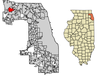
South Barrington is a residential suburb in Cook County, Illinois, United States, south of Barrington. Per the 2020 census, the population was 5,077. South Barrington is a wealthy suburb of Chicago. It is the location of the famous megachurch Willow Creek Community Church, Goebbert's Pumpkin Patch and Farm, and a lifestyle center named The Arboretum of South Barrington.

<span class="mw-page-title-main">Streamwood, Illinois</span> Village in Illinois, United States

Streamwood is a village in Cook County, Illinois, United States. Per the 2020 census, the population was 39,577. It is a northwest suburb of Chicago, and is a part of the Chicago metropolitan area.

<span class="mw-page-title-main">Bloomingdale, Illinois</span> Village in Illinois, United States

Bloomingdale is a village in DuPage County, Illinois, United States, settled in 1833, and 25 miles northwest of downtown Chicago. The population was 22,382 at the 2020 census.

<span class="mw-page-title-main">Glendale Heights, Illinois</span> Village in Illinois, United States

Glendale Heights is a village in DuPage County, Illinois, United States. Per the 2020 census, the population was 33,176. The village is almost entirely residential, and is a far west suburb of Chicago.

<span class="mw-page-title-main">Lisle, Illinois</span> Village in Illinois, United States

Lisle is a village in DuPage County, Illinois, United States. The population was 22,390 at the 2010 census, and in 2019 the population was recorded to be 23,270. It is part of the Chicago metropolitan area and the Illinois Technology and Research Corridor. It is also the headquarters of the Nuclear Regulatory Commission Region III.

<span class="mw-page-title-main">West Chicago, Illinois</span> City in Illinois, United States

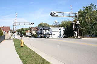
West Chicago is a city in DuPage County, Illinois, United States. The population was 25,614 at the 2020 census. It was formerly named Junction and later Turner, after its founder, John B. Turner, president of the Galena and Chicago Union Railroad (G&CU) in 1855. The city was initially established around the first junction of railroad lines in Illinois, and today is still served by the Union Pacific West Metra service via West Chicago station.

<span class="mw-page-title-main">Wheaton, Illinois</span> City in Illinois, United States

Wheaton is a city in Milton and Winfield Townships and is the county seat of DuPage County, Illinois, United States. It is located approximately 25 miles (40 km) west of Chicago. As of the 2020 census, Wheaton's population was 53,970, making it the 27th most populous municipality in Illinois.

<span class="mw-page-title-main">Winfield, Illinois</span> Village in Illinois, United States

Winfield is an incorporated village located in Milton and Winfield Townships, DuPage County, Illinois, United States. The DuPage River headwaters are located directly to the north, and the river runs through the village. The population was 9,080 at the 2010 census and as of 2019, the estimated population was 9,636.

<span class="mw-page-title-main">Sugar Grove, Illinois</span> Village in Illinois, United States

Sugar Grove is a village in Kane County, Illinois, United States. The population at the 2010 census was 8,997, and in 2018 the estimated population was 9,803.

<span class="mw-page-title-main">Lake Villa, Illinois</span> Village in Illinois, United States

Lake Villa is a village in Lake County, Illinois United States. Per the 2020 census, the population was 8,741. Lake Villa lies within Lake Villa Township and about 50 miles north of Chicago and is part of the United States Census Bureau's Chicago combined statistical area (CSA).

<span class="mw-page-title-main">Bridgeport, Illinois</span> City in Illinois, United States

Bridgeport is a city in Lawrence County, Illinois, United States. The population was 1,886 at the 2010 census.

<span class="mw-page-title-main">Lena, Illinois</span> Village in Illinois, United States

Lena is a village in Stephenson County, Illinois. The population was 2,772 at the 2020 census.

<span class="mw-page-title-main">Crest Hill, Illinois</span> City in Illinois, United States

Crest Hill is a city in Lockport Township, Will County, Illinois, United States. The 2020 census put Crest Hill's population at 20,459.

<span class="mw-page-title-main">Slinger, Wisconsin</span> Village in Washington County, Wisconsin

Slinger is a village in Washington County, Wisconsin, United States. The population was 5,992 at the 2020 census.

<span class="mw-page-title-main">Barrington Township, Cook County, Illinois</span> Township in Illinois, United States

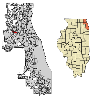
Barrington Township is one of 29 townships in Cook County, Illinois, USA. As of the 2020 census, its population was 16,514 and it contained 6,172 housing units. The northwestern corner of the Cook County panhandle, it is the county's northwesternmost township. It is also by far the least densely populated township in the county, with less than half the population density of the next least Lemont Township.

<span class="mw-page-title-main">Milton Township, DuPage County, Illinois</span> Township in Illinois, United States

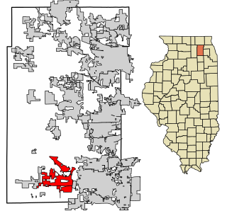
Milton Township is one of nine townships in DuPage County, Illinois, USA. As of the 2020 census, its population was 120,237 and it contained 46,254 housing units.

<span class="mw-page-title-main">Naperville Township, DuPage County, Illinois</span> Township in Illinois, United States

Naperville Township is one of nine townships in DuPage County, Illinois, USA. As of the 2020 census, its population was 104,765 and it contained 41,338 housing units.

<span class="mw-page-title-main">Winfield Township, DuPage County, Illinois</span> Township in Illinois, United States

Winfield Township is one of nine townships in DuPage County, Illinois, USA. As of the 2020 census, its population was 45,836 and it contained 16,445 housing units. It is the least populous of the DuPage County Townships.

References

  1. "2020 U.S. Gazetteer Files". United States Census Bureau. Retrieved March 15, 2022.
  2. 1 2 U.S. Geological Survey Geographic Names Information System: Warrenville, Illinois
  3. 1 2 "Explore Census Data". data.census.gov. Retrieved June 28, 2022.
  4. 1 2 3 History of DuPage County
  5. "US Gazetteer files: 2010, 2000, and 1990". United States Census Bureau. February 12, 2011. Retrieved April 23, 2011.
  6. "G001 - Geographic Identifiers - 2010 Census Summary File 1". United States Census Bureau. Archived from the original on February 13, 2020. Retrieved December 27, 2015.
  7. Cantera Development
  8. "Census of Population and Housing". Census.gov. Retrieved June 4, 2015.
  9. 2000 United States Census Data
  10. City of Warrenville CAFR