Welkait

Last updated
Welkait
ወልቃይት
Wolkait
Welkait.png
Welkait highlighted in red
Country Flag of Ethiopia.svg  Ethiopia
Region Flag of the Tigray Region.svg  Tigray
Area
  Total3,374.52 km2 (1,302.91 sq mi)
Population
 (2007)
  Total138,926

Welkait (also spelled Welkayt, Wolkait or Wolqayt) is a woreda in Western Zone, Tigray Region. [1] This woreda is bordered to the north by Humera and to the south by Tsegede. [2] It is bordered on the east by the North West Zone; the woredas of Tahtay Adiyabo and Asgede Tsimbla lie to the north-east, on the other side of the Tekezé River, and Tselemti to the east. The administrative center of Welkait is Addi Remets; other towns in the woreda include Mai'gaba and Awura.

Contents

Map from 1935 with Welkait as its own region Provinces of Ethiopia, before 1935.svg
Map from 1935 with Welkait as its own region

Overview and History

Following the fall of the communist Derg regime and ascension to power of the Tigray People's Liberation Front, the region incorporated into the Tigray Region due to its historical ties to the Tigray people. [3]

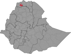
Welkait was historically its own province until 1944 when it was incorporated into Begmeder. This decision by Haile Selassie aimed to punish Tigray for the first Woyane rebellion. The uprising, led by Tigrayan farmers, was a response to Haile Selassie's plans to centralize power in Ethiopia around the government in Shewa, which went against the Tigrayan people's desire for self-determination.

Following the suppression of the rebellion, Haile Selassie assigned Welkait to Begmeder to allow the Amhara-led elite in Begmeder to control the area and weaken Tigrayan unity, preventing further uprisings. Ras Mengesha Seyoum, the last monarch prince in Tigray, attested to the fact that, during his youth, all of Western Tigray and Southern Tigray to Alwuha Milash was known to be ethnically Tigrayan. However, portions of Western Tigray and Southern Tigray were taken from Tigray in the 1940s by Haile Selassie as a punitive measure and to expand Amhara influence. [4] TPLF used this to justify the incorporation of Welkait into the Tigray region.

Welkait is known for its fertile alluvial soil, which grows cash crops such sesame, cotton and also sorghum.

Demographics

The ethnic make up of the region is widely disputed. This question was intensified with its incorporation into the Tigray region. According to a demographic analysis done by the Derg regime about the population of the larger Begmeder province, the population of Welkait in 1984 was 221,692 residents. The same analysis stated that the Tigrayan population of Begmeder was 190,183 people, which made Tigrayans the second largest ethnicity. The study provided evidence that Tigrayans were a majority in Welkait. Multiple linguistic and ethnic maps supporting the population's majority Tigrayan ethnicity. The American sociologist and author Donald N. Levine and the Kenyan politician Peter Anyang' Nyong'o both, prior to Welkait's incorporation into the Tigray region claimed that Welkait was ethnically and linguistically Tigrayan with their respective works, "Wax and Gold: Tradition and Innovation in Ethiopian Culture" and "Class Struggle and the Problem in Eritrea". [3]

However there are arguments made against these claims. That Welkait is historically and ethnically Amhara. These claims come from the idea that TPLF incorporated Welkait into the Tigray region to create a border between Tigray and Sudan. The Welkait comitte was created in Gonder as a response to the incorporation of Welkait into the Tigray region, asking for the Welkait to be incorporated into the Amhara region. There are documents proving that Welkait is historically and majority Amhara and therefore justifying the incorporation of Welkait into Amhara region.

Based on the 2007 census conducted by the Central Statistical Agency of Ethiopia (CSA), this woreda has a total population of 138,926, an increase of 90,186 over the 1994 national census, of whom 70,504 are men and 68,422 women; 10,758 or 7.74% are urban inhabitants. With an area of 3,374.52 km2 (1,302.91 sq mi), Wolqayt has a population density of 41.17 /km2, which is greater than the Zone average of 28.94/km2. A total of 30,375 households were counted in this woreda, resulting in an average of 4.57 persons in a household, and 29,336 housing units. The majority of the inhabitants said they practiced Ethiopian Orthodox Christianity, with 97.28% reporting that as their religion, while 2.71% of the population were Muslim. [5]

The 1994 national census reported a total population for this woreda of 90,186, of whom 45,657 were men and 44,529 were women; 4,597 or 5.1% of its population were urban dwellers. The two largest ethnic groups reported in Wolqayt were the Tigrayan (96.58%), and the Amhara (3.03%); all other ethnic groups made up 0.39% of the population. Tigrinya is spoken as a first language by 97.14%, and 2.75% speak Amharic; the remaining 0.11% spoke all other primary languages reported. 96.75% of the population said they were Ethiopian Orthodox Christians, and 3.09% were Muslim. Concerning education, 3.9% of the population were considered literate, which is less than the Zone average of 9.01%; 3.36% of children aged 7–12 were in primary school, which is less than the Zone average of 11.34%; a negligible number of the children aged 13–14 were in junior secondary school, which is also less than the Zone average of 0.65%; and a negligible number of children aged 15–18 were in senior secondary school, which is less than the Zone average of 0.51%. Concerning sanitary conditions, about 1% of the urban houses and about 8% of all houses had access to safe drinking water at the time of the census; about 4% of the urban and about 4% of all houses had toilet facilities. [6]

Ethnicity

Ethnic Group1994 Census [7] 2007 Census* [8]
Tigrayan (Tigrinya) people 96.58%93.52%
Amhara 3.03%6.48%
Kunama -0.31%
Oromo -0.35%
Eritreans 0.21%0.03%
Afar 0.02%0.02%
Agaw 0.04%0.10%
Irob -0.11%
Sudanese 0.07%

*Urban and Rural Mi'irabawi Zone statistics because none are available for Welkait specifically.

Mother Language

Language1994 Census [9] 2007 Census* [10]
Tigrinya 97.14%86.73%
Amharic 2.75%12.18%
Afaan Oromo 0.01%0.33%
Kunama -0.32%
Agaw 0.06%0.09%

*Urban and Rural Mi'irabawi Zone statistics because none are available for Welkait specifically.

Religion

Religion1994 Census [11] 2007 Census [12]
Orthodox Christian 96.75%97.28%
Protestant 0.03%-
Muslim 3.09%2.71%

Economy

Agriculture

A sample enumeration performed by the CSA in 2001 interviewed 24,417 farmers in this woreda, who held an average of 0.99 hectares of land. Of the 24,286 hectares of private land surveyed, over 86.69% was in cultivation, 1.27% pasture, 10.37% fallow, 0.03% in woodland, and 1.65% was devoted to other uses. For the land under cultivation in this woreda, 63.29% was planted in cereals, 4.19% in pulses, 18.24% in oilseeds, and 0.17% in vegetables is missing.[ clarification needed ] The area planted in gesho was 25 hectares; the area in fruit trees is missing.[ clarification needed ] 79.64% of the farmers both raised crops and livestock, while 10.96% only grew crops and 9.4% only raised livestock. Land tenure in this woreda is distributed amongst 73.93% owning their land, 25.09% renting, and 0.98% reported as holding their land under other forms of tenure. [13] The intensive agriculture is necessary to feed people of the region due to the burgeoning human population, but continuing conversion of natural lands to agriculture is taking a toll on biodiversity in the area.[ citation needed ]

Sugar industry

The Ethiopian Sugar Corporation is building a sugar mill in Welkait region. [14]

Transportation

Ground Travel

In May 2010 construction was underway on a 98-kilometer road westwards from Adi Remets to Dejena Densha; construction of a road in the other direction, eastwards from Adi Remets to Dedebit in Asgede Tsimbla woreda, was awarded that month to Sur Construction for 801 million birr. [15]

2020 woreda reorganisation

In 2020, Welkait woreda became inoperative and its territory belongs to the following new woredas:

Related Research Articles

<span class="mw-page-title-main">Mekelle</span> Capital of Tigray Region, Ethiopia

Mekelle, or Mekele, is a special zone and capital of the Tigray Region of Ethiopia. Mekelle was formerly the capital of Enderta awraja in Tigray. It is located around 780 kilometres (480 mi) north of the Ethiopian capital Addis Ababa, with an elevation of 2,254 metres (7,395 ft) above sea level. Administratively, Mekelle is considered a Special Zone, which is divided into seven sub-cities. It is the economic, cultural, and political hub of northern Ethiopia.

<span class="mw-page-title-main">Dessie</span> Town in Amhara Region, Ethiopia

Dessie is a town in north-central Ethiopia. Located in the South Wollo Zone of the Amhara Region, it sits at a latitude and longitude of 11°8′N39°38′E, with an elevation between 2,470 and 2,550 metres above sea level. Dessie is 400 km to the north of the capital Addis Ababa. It has a population of more than 200,000 people in over 30 wards.

<span class="mw-page-title-main">Debre Tabor</span> Town in Amhara Region, Ethiopia

Debre Tabor is a town and woreda in northern Ethiopia. Located in the Debub Gondar Zone of the Amhara Region, about 100 kilometers southeast of Gondar and 50 kilometers east of Lake Tana, this historic town has a latitude and longitude of 11°51′N38°1′E with an elevation of 2,706 metres (8,878 ft) above sea level. The presence of at least 48 springs in the area contributed to the development of Debre Tabor.

<span class="mw-page-title-main">Western Zone, Tigray</span> Zone in the Tigray Region of Ethiopia

The Western Zone is a zone in the Tigray Region of Ethiopia. It is subdivided into three woredas (districts); from north to south they are Kafta Humera, Welkait and Tsegede. The largest town is Humera. The Western Zone is bordered on the east by the North Western Zone, the south by the Amhara Region, the west by Sudan and on the north by Eritrea. Starting from the late 17th C., internal boundaries are clearly shown, with 37 maps displaying a boundary that is located well south of the Tekeze River, or even south of the Simien mountains. Welkait is explicitly included within a larger Tigray confederation ; it is briefly mapped as part of Amhara in 1891-1894 and part of Gondar from 1944-1990. At other periods it appears independent or part of a larger Mezaga lowland region.

<span class="mw-page-title-main">Humera</span> Town in Tigray Region, Ethiopia

Humera is a town in the Kafta Humera woreda in the Tigray Region of Ethiopia. Located in the Western Zone the town has an elevation of 585 metres (1,919 ft) above sea level. The Tekezé river borders the town to the north. Humera is a very important regional agricultural center based on intensive agriculture. It is the last Ethiopian town south of the border with Eritrea and Sudan, and is considered to be a strategically important gateway to Sudan.

<span class="mw-page-title-main">La'ilay Adiyabo</span> District in Tigray Region, Ethiopia

La'ilay Adiyabo is a woreda in the Tigray Region of Ethiopia. Part of the North Western Zone, La'ilay Adiyabo is bordered on the south by Tahtay Koraro, on the southwest by Asigede Tsimbela, on the northwest by Tahtay Adiyabo, on the northeast by the Mareb River which separates it from Eritrea, on the east by the Central Zone, and on the southeast by Medebay Zana. The administrative center of this woreda is Addi Daero; other towns in La'ilay Adiyabo include Addi Nebreid.

<span class="mw-page-title-main">Medebay Zana</span> District in Tigray Region, Ethiopia

Medebay Zana is an Ethiopian District or woreda in the Tigray Region of Ethiopia. Part of the Semien Mi'irabawi Zone, Medebay Zana is bordered on the south by the Tekeze River which separates Tahtai Adyabo from Tselemti, on the southwest by Asgede Tsimbla, on the northwest by Tahtay Koraro, on the north by La'ilay Adyabo, and on the east by the Mehakelegnaw (Central) Zone. The administrative center of this woreda is Selekhlekha; other towns in Medebay Zana include Debre Kerbe.

<span class="mw-page-title-main">Tsimbla</span> District in Tigray Region, Ethiopia

Tsimbla is a woreda in Tigray Region, Ethiopia. Part of the Semien Mi'irabawi Zone, Tsimbla is bordered along the south by the Tekeze River which separates the woreda on the south from Tselemti and to the west by the Asgede, then on the northwest by Tahtay Adyabo, on the north by La'ilay Adiyabo, on the northeast by Tahtay Koraro, and on the east by Medebay Zana. The administrative center of this woreda is in Inda Aba Guna, a separate town; other towns in Tsimbla include Adi Gebru and Debre Abai.

<span class="mw-page-title-main">Tselemti</span> District in Tigray Region, Ethiopia

Tselemti is an Ethiopian District, or woreda, in the Tigray Region of Ethiopia. Part of the Semien Mi'irabawi Zone, Tselemti is bordered on the south by the Amhara Region, on the west by the Mi'irabawi Zone, on the north by Asigede Tsimbela, on the northeast by Medebay Zana, and on the east by the Maekelay Zone. The Tekezé defines the boundary between Tselemti and both the last two woredas and the Zone; other rivers in this woreda include the Abata, a tributary of the Tekezé. The administrative center of this woreda is Mai Tsebri; other towns in Tselemti include Dima.

<span class="mw-page-title-main">Abergele (woreda)</span> Woreda in Tigray, Ethiopia

Tanqua Abergele is one of the Districts of Ethiopia, or woredas, in the Tigray Region of Ethiopia. Part of the Mehakelegnaw Zone, Abergele is bordered on the south by the Wag Hemra Zone of Amhara Region, then by the Tekezé River on the west which separates it from North Gondar Zone of Amhara Region, on the north by Kola Tembien, on the east by Degua Tembien and on the southeast by the Debub Misraqawi Zone. The administrative center of this woreda is Yechila; other towns in Abergele include Sele and Jijike. Abergele is one of the low lying districts of central Tigray and the Tanqua River, which originates near Hagere Selam, flows through this woreda and joins the Geba just north of Jijike. It further feeds the Tekezé River. The Tekezé Dam is also located in this woreda.

Kobo or Raya Kobo is a woreda in the Amhara Region of Ethiopia. Located in the northeast corner of the North Wollo Zone, Kobo is bordered on the south by the Logiya River which separates it from Habru and Guba Lafto, on the west by Gidan, on the north by Tigray Region, and on the east by the Afar Region. Towns in Kobo include Gobiye, Kobo and Robit.

Berehet is one of the woredas in the Amhara Region of Ethiopia. Part of the Semien Shewa Zone, Berehet is bordered on the south by the Germama River which separates it from Menjarna Shenkora, on the west by Hagere Mariamna Kesem, on the north by Asagirt, and on the east by the Afar Region. The major town in Berehet is Metiteh Bila.

Dembecha Zuria is one of the woredas in the Amhara Region of Ethiopia. Part of the Mirab Gojjam Zone, Dembecha is bordered on the west by Bure, on the northwest by Jabi Tehnan, on the north by Dega Damot, and on the east and south by the Misraq Gojjam Zone. Towns in Dembecha include Addis Alem, Dembecha and Yechereka.

<span class="mw-page-title-main">North Western Zone, Tigray</span> Zone in Tigray Region of Ethiopia

The North Western Zone is a zone in Tigray Region of Ethiopia. It is bordered on the east by the Central Zone, the south by the Amhara Region, the west by the Western Zone and on the north by Eritrea. The Zone is subdivided into the six woredas (districts), which are Asgede, Tsimbla, La'ilay Adiyabo, Medebay Zana, Tahtay Adiyabo, Tahtay Koraro and Tselemti. Major towns and cities in the zone include Shire, Sheraro, Inda Aba Guna, Selekleka, Adi Daero, May Tsebri. The North Western Zone was split off from Western Zone in 2005.

<span class="mw-page-title-main">Fano (militia)</span> Amhara youth militia in Ethiopia

Fano is an ethno-nationalist Amhara militia and former protest movement. It has engaged in violent clashes throughout Ethiopia in the name of neutralizing perceived threats to the Amhara people. Fano has absorbed many units and personnel of the Amhara Regional Special Forces that did not integrate into the Ethiopian National Defense Force (ENDF). Fano militias are have been involved in armed conflicts with the Tigray People's Liberation Front (TPLF), the Oromo Liberation Army (OLA), and the ENDF. They have also clashed with the Sudanese Armed Forces (SAF) on the border of Ethiopia and Sudan.

<span class="mw-page-title-main">Ethnic discrimination in Ethiopia</span> Ethnic conflicts in Ethiopia during the 20th and 21st centuries

Ethnic discrimination in Ethiopia during and since the Haile Selassie epoch has been described using terms including "racism", "ethnification", "ethnic identification, ethnic hatred, ethnicization", and "ethnic profiling". During the Haile Selassie period, Amhara elites perceived the southern minority languages as an obstacle to the development of an Ethiopian national identity. Ethnic discrimination occurred during the Haile Selassie and Mengistu Haile Mariam epochs against Hararis, Afars, Tigrayans, Eritreans, Somalis and Oromos. Ethnic federalism was implemented by Tigray People's Liberation Front (TPLF) leader Meles Zenawi and discrimination against Amharas, Ogaden, Oromos and other ethnic groups continued during TPLF rule. Liberalisation of the media after Abiy Ahmed became prime minister in 2018 led to strengthening of media diversity and strengthening of ethnically focussed hate speech. Ethnic profiling targeting Tigrayans occurred during the Tigray War that started in November 2020.

<span class="mw-page-title-main">Ethiopian civil conflict (2018–present)</span> Episode of intrastate conflicts during Abiy Ahmeds administration

Following the 2018 dissolution of the ethnic federalist, dominant party political coalition, the Ethiopian People's Revolutionary Democratic Front, there was an increase in tensions within the country, with newly resurgent regional and ethnically based factions carrying out armed attacks on military and civilians in multiple conflicts throughout Ethiopia.

<span class="mw-page-title-main">Tigrayan nationalism</span> Ethnic nationalism

Tigrayan nationalism is an ethnic nationalism that advocates the interests of Tigrayan people in Ethiopia. Inspired predominantly by the Tigray People's Liberation Front (TPLF) with its predecessor Tigray Liberation Front (TLF), this type of nationalism holds that Tigrayans are an independent group with unique ancestry, heritage, history and culture outside Ethiopia. As such, they claim Tigray is the source of Ethiopian civilization and utterly a benefactor of state-building without other local ethnic groups. Tigrayan nationalists accuse Amharas of imposing their cultural, economic and political hegemony over Tigrayans.

<span class="mw-page-title-main">Asgede</span> District in Tigray Region, Ethiopia

Asgede is a woreda in Tigray Region, Ethiopia. Part of the Semien Mi'irabawi Zone, Asgede is bordered along the south by the Tekeze River which separates the woreda on the south from Tselemti and to the west and northwest by Tahtay Adyabo, on the north by La'ilay Adiyabo, on the northeast by Tahtay Koraro, and on the east by Tsimbla. Although Mayhansse town is the largest town and center of the woreda, corrupt cadres have deflected the administrative center to Kisad Gaba town so that they can easily work while living in Shire. Other towns include Dedebit, Adi Mehameday, Hibret and Hitsats.

<span class="mw-page-title-main">Welkait question</span> Controversial dispute regarding the Ethiopian city Welkait

The Welkait question involves a controversial territorial dispute surrounding the Ethiopian area Welkait, which is situated in the present-day Tigray Region. Welkait had been an independent area but was incorporated within Begmeder province, but after the fall of the Derg in 1991, the area was given by the TPLF government to Tigray's Western Zone. During Abiy Ahmed administration, the Tigray and Welkait Committee counterparts held peaceful talks in Gondar on 19 April 2018. Abiy pleaded the Welkait question should be addressed in peaceful resolution.

References

  1. Wosenyelew, Tedla (August 21, 2021). "Welkait, Ethiopia: Geo Strategic importance and the Consequential Annexation by TPLF". Horn of Africa Insight.
  2. United Nations Office for the Coordination of Humanitarian Affairs (27 March 2013). "Ethiopia Administrative Map" (PDF). Relief Web. Retrieved 4 April 2018.
  3. 1 2 Tesfaye, Abel (2022-08-03). "Under Ethiopia's federal system, Western Tigray belongs in Tigray". Ethiopia Insight. Retrieved 2024-01-25.
  4. Ras mengesha sium briefly explained on the border of tigray , retrieved 2024-01-25
  5. Census 2007 Tables: Tigray Region Archived 2010-11-14 at the Wayback Machine , Tables 2.1, 2.4, 2.5 and 3.4.
  6. 1994 Population and Housing Census of Ethiopia: Results for Tigray Region, Vol. 1, part 1 Archived 2008-11-19 at the Wayback Machine , Tables 2.1, 2.12, 2.19, 3.5, 3.7, 6.3, 6.11, 6.13 (accessed 30 December 2008)
  7. The 1994 Population and Housing Census of Ethiopia Results for Tigray Region. Vol. 1. Addis Ababa: Central Statistical Authority. 1995. p. 70.
  8. 2007 National Population and Housing Census. Addis Ababa: Central Statistical Authority. 2008. pp. 72–73.
  9. The 1994 Population and Housing Census of Ethiopia Results for Tigray Region. Addis Ababa: Ethiopian Statistical Agency. 1995. p. 82.
  10. 2007 National Population and Housing Census. Addis Ababa: Central Statistical Agency. 2008. pp. 86–87.
  11. 1994 Population and Housing Census Results for Tigray Region. Vol. 1. Addis Ababa: Central Statistical Agency. 1995. p. 98.
  12. 2007 National Housing and Population Census. Addis Ababa: Ethiopian Statistical Agency. 2008. p. 99.
  13. "Central Statistical Authority of Ethiopia. Agricultural Sample Survey (AgSE2001). Report on Area and Production - –Tigray (read Amhara) Region. Version 1.1 - December 2007" (accessed 26 January 2009)
  14. "Ethiopia injects US$4 billion into sugar factories". The Africa Report. 20 December 2011. Retrieved 15 October 2016.
  15. "Tigray, Southern towns get first roads", Addis Fortune 2 May 2010 (accessed 16 October 2016)