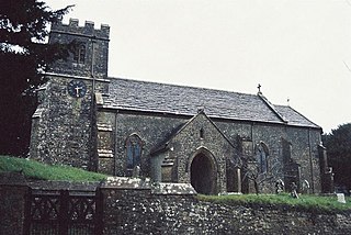
East Stour is a village and civil parish in the county of Dorset in southern England. It lies within the North Dorset administrative district, about 2 miles (3.2 km) south of the town of Gillingham. The village is sited half a mile from the east bank of the River Stour in the Blackmore Vale and two miles west of the broadly conical local landmark Duncliffe Hill. Above the west bank of the river, about a mile away, is the village of West Stour. The A30 London to Penzance road passes through the village. In the 2011 census the civil parish had a population of 573.

Stalbridge is a small town and civil parish in Dorset, England, situated in the Blackmore Vale, near the border with Somerset. In the 2011 census the civil parish—which includes the small settlement of Stalbridge Weston to the southwest—had 1,160 households and a population of 2,698. The nearest towns are Sturminster Newton, 4 miles (6.4 km) south east, Sherborne, 6 miles (9.7 km) west, and Shaftesbury, 7 miles (11 km) north east. Stalbridge is situated on the A357 on a low limestone ridge, one mile west of the River Stour. It officially became a town in April 1992.

Abbotsbury is a village and civil parish in the English county of Dorset. It is in the Dorset unitary authority area and is situated about 1 mile (1.6 km) inland from the English Channel coast. In the 2011 census the civil parish had a population of 481.

Hilton is a village and civil parish in the county of Dorset in southern England. It is sited at an altitude of 135 metres in a small valley which drains chalk hills in the eastern part of the Dorset Downs, approximately 8 miles (13 km) west-south-west of the town of Blandford Forum. The summit of Bulbarrow Hill is 1.5 miles (2.4 km) north of the village. In the 2011 census the parish—which includes the settlement of Ansty to the west—had 231 dwellings, 206 households and a population of 477.

Iwerne Courtney, also known as Shroton, is a village and civil parish in the English county of Dorset. It lies within the North Dorset administrative district, approximately 4 miles (6 km) north-west of the town of Blandford Forum. It is sited by the small River Iwerne between Hambledon Hill to the south-west and the hills of Cranborne Chase to the east. In 2001 the parish had 187 households and a population of 400. In 2013 the estimated population of the parish was 410.

Iwerne Minster is a village and civil parish in Dorset, England. It lies on the edge of the Blackmore Vale, approximately midway between the towns of Shaftesbury and Blandford Forum. The A350 main road between those towns passes through the edge of the village, just to the west. In the 2011 Census the civil parish had a population of 978.

Maiden Newton is a village and civil parish in the county of Dorset in south-west England. It lies within the Dorset Council administrative area, about 9 miles (14 km) north-west of the county town Dorchester. It is sited on Upper Greensand at the confluence of the River Frome with its tributary of equivalent size, the Hooke. Both these rivers have cut valleys into the surrounding chalk hills of the Dorset Downs. Maiden Newton railway station, which serves the village, is situated on the Heart of Wessex Line. The A356 main road also passes through the village. In the 2011 census the parish—which does not include the adjacent settlements of Frome Vauchurch and Tollerford— had a population of 1,119.

Child Okeford is a village and civil parish in the county of Dorset in southern England, situated 3 miles (4.8 km) east of the small town of Sturminster Newton in the North Dorset administrative district. Child Okeford lies downstream from Sturminster, along the River Stour, which passes half a mile west of the village. In the 2011 census the civil parish had a population of 1,114.

Compton Abbas is a village and civil parish in the county of Dorset in southern England. It lies within the North Dorset administrative district, 3 miles (4.8 km) south of the town of Shaftesbury. It is sited on greensand strata on the edge of the Blackmore Vale, below the chalk downs of Cranborne Chase. On top of these hills is Compton Abbas Airfield. The A350 road between Wiltshire and the south coast passes through the village. In the 2011 census the civil parish had a population of 216. The name Compton Abbas derives from the Saxon "cumb-ton", meaning 'village in a narrow valley', plus "abbas" which refers to Shaftesbury Abbey. The church, St. Mary's, was built in 1866 to replace the older structure which was more remote from the village.

Compton Valence is a small village and civil parish in the county of Dorset in southern England. It lies approximately 7 miles (11 km) west of the county town Dorchester. It is sited at the head of a narrow valley, formed by a small tributary of the River Frome, and is surrounded by the hills of the Dorset Downs, which has led to it having been described as "a pocket of habitation in the downs." Dorset County Council estimate that in 2013 the population of the parish was 50.

Fontmell Magna is a village and civil parish in north Dorset, England. It is situated in the Blackmore Vale, close to the chalk hills of Cranborne Chase, on the A350 road 5 miles (8 km) south of Shaftesbury and 8 miles (13 km) north of Blandford Forum. In the 2011 census the parish had a population of 734.

Motcombe is a village and civil parish in the county of Dorset, England. It lies in the North Dorset administrative district, about 2 miles (3.2 km) north of the town of Shaftesbury. It is sited on Kimmeridge clay soil beneath hills at the edge of the Blackmore Vale. The parish is one of the largest in Dorset. In the 2011 census the parish had 611 dwellings, 564 households and a population of 1,474.

Powerstock is a village and civil parish in south west Dorset, England, situated in a steep valley on the edge of the Dorset Downs, 5 miles (8.0 km) north-east of the market town of Bridport. The civil parish includes the village of West Milton to the west and the summit and northern slopes of Eggardon Hill to the south-east. Powerstock village contains many cottages and 2 inns: The Three Horseshoes near the church and The Marquis of Lorne Inn on the other side of the valley in a small hamlet called Nettlecombe. The small Mangerton River runs through the valley. In 2013 the parish had an estimated population of 290. In the 2011 census figures have been published for Powerstock parish combined with the small parish of North Poorton to the north; the population in this area was 358.

Rampisham is a village and civil parish in the county of Dorset in southern England, situated approximately 11 miles (18 km) northwest of the county town Dorchester. The village is sited on greensand in a valley surrounded by the chalk hills of the Dorset Downs. The parish includes the hamlet of Uphall northwest of the main village.

Sydling St Nicholas is a village and civil parish in Dorset within southwest England. The parish is 5 to 9 miles northwest of the county town Dorchester and covers most of the valley of the small Sydling Water in the chalk hills of the Dorset Downs. The parish has an area of 2,075 hectares and includes the hamlet of Up Sydling in the north.

Askerswell is a small village and civil parish in the county of Dorset in southwest England. It is sited on the small River Asker. It lies 11 miles (18 km) west of the county town Dorchester. The parish has an area of 1,724 acres and in the northeast includes the western slopes of Eggardon Hill, including part of the Iron Age hill fort close to its summit. In the 2011 census the civil parish had a population of 154.

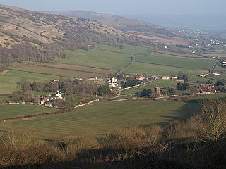
Compton Bishop is a small village and civil parish, at the western end of the Mendip Hills in the English county of Somerset. It is located close to the historic town of Axbridge. Along with the village of Cross and the hamlets of Rackley and Webbington it forms the parish of Compton Bishop and Cross.

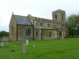
Edworth is a hamlet and civil parish in the Central Bedfordshire district of the county of Bedfordshire, England about 12 miles (19 km) south-east of the county town of Bedford. It sits just off the Great North Road (A1) between Baldock and Biggleswade. There are fewer than one hundred inhabitants in the village. At the 2011 Census the village population was included in the civil parish of Dunton.

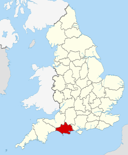
Dorset is a county located in the middle of the south coast of England. It lies between the latitudes 50.512°N and 51.081°N and the longitudes 1.682°W and 2.958°W, and occupies an area of 2,653 km². It spans 90 kilometres (56 mi) from east to west and 63 kilometres (39 mi) from north to south.

Nether Cerne is a hamlet and civil parish in the English county of Dorset. It lies within the Dorset unitary authority administrative area, about 5 miles (8.0 km) north of the county town Dorchester and 12 miles (19 km) south of Sherborne. The A352 road which connects those towns lies about 250 metres (270 yd) to the west. Dorset County Council's latest (2013) estimate of the parish population is 20.


