
The Archwood Avenue Historic District is a historic residential district in the Brooklyn Centre neighborhood of Cleveland, Ohio, United States. Composed of houses constructed around the turn of the twentieth century, it has been one of the neighborhood's most important streets since it was established, and it was designated a historic district in 1987.

The city of Davenport, Iowa, United States has neighborhoods dating back to the 1840s. The Davenport Plan and Zoning Commission divided the city into five areas: downtown, central, east end, near north, and northwest and west end. The neighborhoods contain many architectural designs, including Victorian, Queen Anne, and Tudor Revival. Many of the original neighborhoods were first inhabited by German settlers.

Glenville Historic District, also known as Sherwood's Bridge, is a 33.9 acres (13.7 ha) historic district in the Glenville neighborhood of the town of Greenwich, Connecticut. It is the "most comprehensive example of a New England mill village within the Town of Greenwich". It "is also historically significant as one of the town's major staging areas of immigrants, predominantly Irish in the 19th century and Polish in the 20th century" and remains "the primary settlement of Poles in the town". Further, "[t]he district is architecturally significant because it contains two elaborate examples of mill construction, designed in the Romanesque Revival and a transitional Stick-style/Queen Anne; an excellent example of a Georgian Revival school; and notable examples of domestic and commercial architecture, including a Queen Anne mansion and an Italianate store building."

The Homestead–Horton Neighborhood Historic District encompasses a small turn-of-the-20th century neighborhood area in Brattleboro, Vermont. Located on a portion of Canal Street and all of Horton and Homestead Places, the district includes a significant number of Queen Anne Victorians, as well as the Italianate home of Jacob Estey, proprietor of the Estey Organ Company, one of the city's larger employers. The district was listed on the National Register of Historic Places in 2009.

The Washington Street Historic District is north of Valparaiso's downtown. The neighborhood has tree-lined streets with many examples of late nineteenth and early twentieth century houses and public buildings. Valparaiso began to expand after the railroads came through the township in the 1860s; Pittsburgh, Fort Wayne and Chicago Railroad, the New York, Chicago and St. Louis Railroad and the Grand Trunk Railroad. Residential neighborhoods grew up between the business district and the railroads. On Valparaiso's south side industrial and transportation area expanded, thus residential development was north of downtown.

The Fenelon Place Residential Historic District is a nationally recognized historic district located in Dubuque, Iowa, United States. It was listed on the National Register of Historic Places in 2015. At the time of its nomination it consisted of 218 resources, which included 171 contributing buildings, two contributing structures, one contributing site, 43 non-contributing buildings, and one non-contributing structure. The residential area that makes up the district is located on a plateau located directly above the Mississippi River Valley. This was the first bluff-top neighborhood in Dubuque that established elevator service. The first Fenelon Place Elevator, listed on the National Register in 1978, was completed in 1894. Early houses on the plateau were small cottages built by lead miners. They were replaced by large houses that were built in two periods. The first period at the end of the 19th century saw houses built in the Italianate, Gothic Revival, Second Empire, and Queen Anne styles. House in the second period in the beginning of the 20th century were largely built in the Classical Revival and Tudor Revival styles.

The South Monroe Street Historic District is a primarily residential historic district located at 89-175 and 90-146 South Monroe Street, and 17 Park Avenue, in Coldwater, Michigan. It was listed on the National Register of Historic Places in 1990. It is the best-preserved section of modest houses constructed in Coldwater in the 1850s-1870s, and contains the former Lake Shore & Michigan Southern depot, constructed in 1883.

The Center Avenue Neighborhood Residential District is a residential historic district located in Bay City, Michigan, running primarily along Center, Fifth, and Sixth Avenues between Monroe and Green Avenues, with additional portions of the district along Fourth between Madison and Johnson, down to Tenth Avenue between Madison and Lincoln, along Green to Ridge, and around Carroll Park. The original section, along Center and portions of Fifth and Sixth, was listed on the National Register of Historic Places in 1982. A boundary increase including the other sections of the neighborhood was listed in 2012.

The Midland Street Commercial District is a primarily commercial historic district located primarilyalong Midland Street, between Catherine and Litchfield Streets, in Bay City, Michigan. It was listed on the National Register of Historic Places in 1982.

The Downtown Holly Commercial District is a commercial historic district located primarily South Saginaw Street and Battle Alley in Holly, Michigan. The district is roughly bounded by Maple Street, South Broad Street, First Street, and the Grand Trunk Railroad tracks. It was listed on the National Register of Historic Places in 1986.

The Westside Neighborhood Historic District is a residential historic district, located along West Maple, and West Ash Street between South McRoberts Street and the railroad grade east of Sycamore Creek in Mason, Michigan. It also includes The district was listed on the National Register of Historic Places in 1985.

The Dibbleville-Fentonville Historic District is a primarily residential historic district roughly bounded by Shiawassee, Riggs, Holly and George Streets in Fenton, Michigan. It was listed on the National Register of Historic Places in 1982.

The Michigan Avenue-Genessee Street Historic Residential District is a primarily residential historic district, located along Michigan Ave between Clinton Street and the railroad tracks, and along Genesee Street from Michigan Avenue to Shiawassee Street in Owosso, Michigan. It was listed on the National Register of Historic Places in 1980.

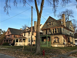
The Saginaw Central City Historic Residential District is a primarily residential historic district located in Saginaw, Michigan and roughly bounded by Federal Avenue, South Baum Street, Park Avenue, and Hoyt Avenue. The district was listed on the National Register of Historic Places in 1979.

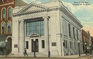
The East Saginaw Historic Business District is a primarily commercial historic district located in Saginaw, Michigan and roughly bounded by Federal, North Water, North Washington and North Franklin Streets. It was listed on the National Register of Historic Places in 1982.
The North Jefferson Avenue Historic District is a small residential historic district located at the intersection of Carroll and Jefferson Avenues in Saginaw, Michigan. It was listed on the National Register of Historic Places in 1982.

The North Michigan Avenue Historic District is a residential historic district located along Michigan Avenue, from Monroe Street on the south to just north of Remington Street in Saginaw, Michigan. It was listed on the National Register of Historic Places in 1982.
The Saginaw City Historic Business District is a primarily commercial historic district located between Michigan Avenue and the Saginaw River, from Cleveland to Van Buren Avenues, in Saginaw, Michigan. It was listed on the National Register of Historic Places in 1982.
The South Jefferson Avenue Historic District is a residential historic district located along South Jefferson between Meredith and East Holland, and along East Remington and East Holland between Jefferson and Sheridan in Saginaw, Michigan. It was listed on the National Register of Historic Places in 1982.
The South Michigan Avenue Historic District is a primarily residential historic district located along South Michigan Avenue between Lyon and Lee Streets in Saginaw, Michigan. It was listed on the National Register of Historic Places in 1982.


