
Raleigh County is a county in the U.S. state of West Virginia. As of the 2020 census, the population was 74,591. Its county seat is Beckley. The county was founded in 1850 and is named for Sir Walter Raleigh. Raleigh County is included in the Beckley, West Virginia, Metropolitan Statistical Area.

U.S. Route 19 or U.S. Highway 19 (US 19) is a north–south United States Numbered Highway in the Eastern United States. Despite encroaching Interstate Highways, the route has remained a long-haul road, connecting the Gulf of Mexico with Lake Erie.

U.S. Route 119 (US 119) is a spur of US 19. It is a north–south route that was an original United States highway of 1926. It is Corridor G of the Appalachian Development Highway System (ADHS) east of US 23 and KY 80 in Kentucky to Interstate 64 at Charleston, West Virginia.

U.S. Route 321 (US 321) is a spur of U.S. Route 21. It runs for 516.9 miles (831.9 km) from Hardeeville, South Carolina to Lenoir City, Tennessee; with both serving as southern termini. It reaches its northernmost point at Elizabethton, Tennessee, just northeast of Johnson City. Because of its unusual "north–south–north" routing, U.S. Route 321 intersects both Interstate 40 and U.S. Route 70 three separate times. The highway serves different roles in each state: An alternate route to interstates in South Carolina, a major highway in North Carolina, and a scenic route in Tennessee.

U.S. Route 421 is a diagonal northwest–southeast United States Numbered Highway in the states of North Carolina, Tennessee, Virginia, Kentucky, and Indiana. The highway runs for 941 miles (1,514 km) from Fort Fisher, North Carolina, to US 20 in Michigan City, Indiana. Along its routing, US 421 serves several cities including Wilmington, North Carolina; Greensboro, North Carolina; Bristol, Tennessee and Virginia; Lexington, Kentucky; and Indianapolis, Indiana. US 421 is a spur route of US 21, which it meets west of Yadkinville, North Carolina.

U.S. Route 522 is a spur route of US 22 in the states of Virginia, West Virginia, Maryland, and Pennsylvania. The U.S. Highway travels in a north-south direction, and runs 308.59 miles (496.63 km) from US 60 near Powhatan, Virginia, to its northern terminus at US 11 and US 15 near Selinsgrove, Pennsylvania. US 522 serves many small cities and towns in the Piedmont, Blue Ridge Mountains, and northern Shenandoah Valley of Virginia. The highway serves the Virginia communities of Goochland, Mineral, Culpeper, the town of Washington, and Front Royal and the independent city of Winchester. US 522 then follows the Ridge-and-Valley Appalachians north and then east through the Eastern Panhandle of West Virginia, a 2-mile-wide (3.2 km) stretch of Western Maryland, and South Central Pennsylvania to its terminus in the Susquehanna Valley. The highway serves Berkeley Springs, West Virginia; Hancock, Maryland; and the Pennsylvania communities of McConnellsburg, Mount Union, Lewistown, and Middleburg.

U.S. Route 121 (US 121) is a proposed U.S. highway designated as the Coalfields Expressway, a four-lane highway stretching from Beckley, West Virginia, to Pound, Virginia, approximately 108 miles (174 km) in length. It is designed to connect Interstate 64 (I-64) and I-77 in West Virginia near Beckley to US 23 in Wise County, Virginia, at Pound. While US 121 will not connect directly to US 21, it will intersect at the latter road's original alignment, now a part of I-77.

West Virginia's 3rd congressional district is an obsolete U.S. congressional district in southern West Virginia. At various times the district covered different parts of the state, but in its final form included the state's second-largest city, Huntington; included Bluefield, Princeton, and Beckley; and has a long history of coal mining, forestry, and farming.
West Virginia Route 97 is an east–west state highway in the U.S. state of West Virginia. The western terminus of the route is at U.S. Route 52 and West Virginia Route 80 in Hanover. The eastern terminus is at exit 42 of the West Virginia Turnpike in Mabscott. West Virginia Route 16, which runs concurrent with WV 97 between Sophia and Mabscott, continues north into Beckley on Robert C. Byrd Drive, the right-of-way of both WV 16 and WV 97.

Southern West Virginia is a culturally and geographically distinct region in the U.S. state of West Virginia. Southern West Virginia has coal mining heritage and Southern affinity, including being part of the Bible Belt. The region is also closely identified with Southwestern Virginia and Eastern Kentucky, with close proximity to Western North Carolina and East Tennessee.

U.S. Route 11E (US 11E) is a divided highway of US 11 in the U.S. states of Tennessee and Virginia. The United States Numbered Highway, which is complemented by US 11W to the north and west, runs 120.94 miles (194.63 km) from US 11, US 11W, and US 70 in Knoxville, Tennessee, north and east to US 11, US 11W, US 19, and US 421 in Bristol, Virginia. US 11E connects Knoxville and the twin cities of Bristol, Virginia, and Bristol, Tennessee, with the East Tennessee communities of Morristown, Greeneville, and Johnson City. The U.S. Highway runs concurrently with US 70 and US 25W east of Knoxville, US 321 from Greeneville and Johnson City, and both US 19W and US 19 between Johnson City and Bristol. US 11E also has an unsigned concurrency with State Route 34 (SR 34) for almost all of its course in Tennessee.

Pennsylvania Route 18 is a major north–south highway in Western Pennsylvania whose southern terminus is at West Virginia Route 69 at the state line in Greene County near the village of Garrison, while the northern terminus is at PA 5 in Lake City. At a length of 205 miles (330 km), PA 18 is the only state route in Pennsylvania — north–south or east–west — to traverse the entire state. It also has the distinction of being the longest state route in Pennsylvania.
North Carolina Highway 16 (NC 16) is a 143.8-mile primary state highway in the U.S. state of North Carolina. Traveling in a north–south direction, it connects the cities and towns of Charlotte, Newton, Conover, Taylorsville, Wilkesboro and Jefferson, linking the Charlotte metropolitan area with the mountainous High Country. NC 16 is part of a three-state route 16 that connects the Charlotte region with northwestern West Virginia.

Interstate 77 (I-77) in the US state of West Virginia is a major north–south Interstate Highway. It extends for 187.21 miles (301.29 km) between Bluefield at the Virginia state line and Williamstown at the Ohio state line.
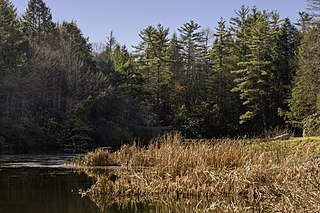
Little Beaver State Park is state park in Raleigh County, West Virginia. It is located near Beckley, West Virginia, about 2 miles (3.2 km) south of I-64 at Grandview Road, exit 129A. The park sits on the shores of 18-acre (0.07 km2) Little Beaver Lake.
Stotesbury is an unincorporated community and former coal town in Raleigh County in the U.S. state of West Virginia that flourished during the 1930s. The community was named for Edward T. Stotesbury, then the president of Beaver Coal Company.
U.S. Route 19 (US 19) runs south to north up through central West Virginia. The route runs from the Virginia state line at Bluefield, north to the Pennsylvania state line south of Mount Morris, Pennsylvania.

In the U.S. state of North Carolina U.S. Route 221 (US 221) is a north–south highway that travels through Western North Carolina. From Chesnee, South Carolina to Independence, Virginia, it connects the cities of Rutherfordton, Marion, Boone and Jefferson between the two out-of-state destinations. Its most memorable section, known as the Little Parkway Scenic Byway between Linville and Blowing Rock, offers area visitors a curvier alternative to the Blue Ridge Parkway and access to Grandfather Mountain.

North Carolina Highway 194 (NC 194) is a primary state highway in the U.S. state of North Carolina. Entirely in the High Country, it runs from US 19E, in Ingalls, to the Virginia state line, near Helton.


