
Summers County is a county located in the U.S. state of West Virginia. As of the 2020 census, the population was 11,959. Its county seat is Hinton. The county was created by an act of the West Virginia Legislature on February 27, 1871, from parts of Fayette, Greenbrier, Mercer and Monroe counties and named in honor of George W. Summers (1804–68).

Greenbrier County is a county in the U.S. state of West Virginia. As of the 2020 census, the population was 32,977. Its county seat is Lewisburg. The county was formed in 1778 from Botetourt and Montgomery counties in Virginia.

Hinton is a city in Summers County, West Virginia, United States. The population was 2,266 at the 2020 census. It is the county seat of Summers County. Hinton was established in 1873 and chartered in 1897. Hinton was named after John "Jack" Hinton, the original owner of the town site. Much of Hinton's downtown was placed on the National Register of Historic Places in 1984.

The New River is a river which flows through the U.S. states of North Carolina, Virginia, and West Virginia before joining with the Gauley River to form the Kanawha River at the town of Gauley Bridge, West Virginia. Part of the Ohio River watershed, it is about 360 miles (580 km) long.

The Greenbrier River is a tributary of the New River, 162 miles (261 km) long, in southeastern West Virginia, in the United States. Via the New, Kanawha and Ohio rivers, it is part of the watershed of the Mississippi River, draining an area of 1,656 square miles (4,290 km2). It is one of the longest rivers in West Virginia.

The Bluestone River is a tributary of the New River, 77 mi (124 km) long, in southwestern Virginia and southern West Virginia in the United States. Via the New, Kanawha and Ohio rivers, it is part of the watershed of the Mississippi River. An 11 mi (18 km) portion of its lower course in West Virginia is designated as the Bluestone National Scenic River.

West Virginia Route 20 is a major north–south state highway in the U.S. state of West Virginia. The southern terminus of the route is at U.S. Route 52 in Bluewell, a small unincorporated suburb of Bluefield. The northern terminus is at West Virginia Route 7 three miles (5 km) east of New Martinsville. WV Route 20 is the longest state route in West Virginia.

West Virginia Route 107 is a north–south state highway located entirely within Hinton, West Virginia, United States. The southern terminus of the route is at West Virginia Route 3 in the Bellepoint neighborhood of southern Hinton. The northern terminus is at West Virginia Route 20 in the city center. WV 107 is a former alignment of WV 20.
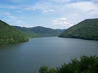
Bluestone Lake is a flood control reservoir located on the New River near Hinton, West Virginia. At its normal pool level, Bluestone Dam impounds a 10.7-mile (17.2 km) stretch of the New and its tributary, the Bluestone River. Normally approximately 2,040 acres (8.3 km2) in size, the lake can grow to over 36 miles (58 km) long at flood control pool. At higher water levels, the lake extends into Giles County, Virginia.

The Bluestone National Scenic River protects a 10.5-mile (16.9 km) section of the Bluestone River in Summers and Mercer counties of southern West Virginia. It was created 26 October 1988 under the Wild and Scenic Rivers Act and is protected by the National Park Service.
Pipestem Resort State Park is a 4,050-acre (1,640 ha) state park located in southern West Virginia, on the border between Mercer and Summers counties. The park was built with grants provided by the Area Redevelopment Administration of the U.S. Department of Commerce under the administration of President John F. Kennedy. It is located in the gorge of the Bluestone River.
Bluestone State Park is a state park in Summers County, West Virginia. The 2,154-acre (872 ha) park is located along the western shore of Bluestone Lake, an impoundment of the New River built and managed by the U.S. Army Corps of Engineers. The park and lake are named after the Bluestone River, that flows into the New River at the park.

Talcott is an unincorporated community in Summers County, West Virginia, United States.

Pence Springs is an unincorporated community in Summers County, West Virginia, United States. It lies along the Greenbrier River to the east of the city of Hinton, the county seat of Summers County. Its elevation is 1,539 feet, and it is located at 37°40′41″N80°43′30″W. It had a post office with the ZIP code 24962 until it was closed in October 2011.

The Greenbrier River Watershed Association (GRWA) is one of the oldest watershed associations in the state of West Virginia, founded in 1990. It has supported the creation of other watershed associations throughout the state and maintains a policy of "upstream courtesy" and "downstream courtesy" with its neighbors.
Clayton is an unincorporated community in Summers County, West Virginia, United States. The community was first settled in 1813. Clayton once had a post office, which opened in 1879 and closed in 1959.
Lowell is an unincorporated community in Summers County, West Virginia, United States. Lowell is located on the Greenbrier River, east of Hinton and southwest of Alderson. The community was first settled in 1770 and is the oldest community in Summers County.
Wiggins is an unincorporated community in Summers County, West Virginia, United States. Wiggins is located on the north bank of the Greenbrier River, east of Hinton.

The Big Draft Wilderness is a 5,144-acre (2,082 ha) U.S. Wilderness area in the Monongahela National Forest of southeast West Virginia, USA. Its name derives from the nearby Big Draft, a tributary of Anthony Creek which is a tributary of the Greenbrier River. Big Draft Wilderness occupies the southernmost acreage of the Monongahela National Forest and is located just south of the Blue Bend Recreation Area. The town White Sulphur Springs lies about 5 miles south of the Wilderness and about 15 miles northeast of Lewisburg.


