
Stinson is an unincorporated community in Calhoun County, West Virginia, United States. It lies along West Virginia Route 16 and the West Fork Little Kanawha River, to the south of the town of Grantsville, the county seat of Calhoun County. Its elevation is 823 feet. At some point, Stinson possessed a post office, which has since been closed.
Chloe is an unincorporated community in Calhoun County, West Virginia, United States. It lies along West Virginia Route 16 and the West Fork Little Kanawha River, to the south of the towns of Grantsville and Arnoldsburg. Its elevation is 794 feet (242 m). Although it is unincorporated, it has a post office, with the ZIP code of 25235.
Millstone is an unincorporated community in Calhoun County, West Virginia, United States. It lies along U.S. Route 33 at the point where West Virginia Route 16 heads northward, to the south of the town of Grantsville, the county seat of Calhoun County. Its elevation is 810 feet. Although it is unincorporated, it has a post office, with the ZIP code of 25261.
Big Bend is an unincorporated community in Calhoun County, West Virginia, United States. It lies along West Virginia Route 5 northwest of the town of Grantsville, the county seat of Calhoun County, along the Little Kanawha River. Its elevation is 682 feet. Although it is unincorporated, it has a post office, with the ZIP code of 26136.
Big Springs is an unincorporated community in Calhoun County, West Virginia, United States. It lies along West Virginia Route 16 to the north of the town of Grantsville, the county seat of Calhoun County. Its elevation is 771 feet. Although it is unincorporated, it has a post office, with the ZIP code of 26137.
Annamoriah is an unincorporated community in Calhoun County, West Virginia, United States. It lies along West Virginia Route 5 to the west of the town of Grantsville, the county seat of Calhoun County. Its elevation is 994 feet. Their post office closed in 1988.
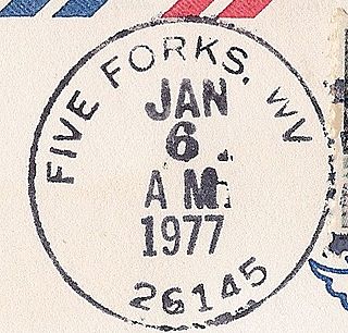
Five Forks is an unincorporated community in Calhoun County, West Virginia, United States. It lies along West Virginia Route 16 to the north of the town of Grantsville, the county seat of Calhoun County. Its elevation is 1,106 feet (337 m). The Five Forks Post Office is closed.
Brooks is an unincorporated community in Summers County, West Virginia, United States. It lies along the New River to the north of the city of Hinton, the county seat of Summers County. Its elevation is 1,657 feet.
Elton is an unincorporated community in Summers County, West Virginia, United States. It lies to the northeast of the city of Hinton, the county seat of Summers County. Its elevation is 1,749 feet. Elton had a post office, with the ZIP code of 25965, until it closed on July 11, 2009.
Forest Hill is an unincorporated community in Summers County, West Virginia, United States. It lies along West Virginia Route 12 to the southeast of the city of Hinton, the county seat of Summers County. Its elevation is 1,926 feet. Although it is unincorporated, it has a post office, with the ZIP code of 24935.
Green Sulphur Springs is an unincorporated community in Summers County, West Virginia, United States. It lies near Interstate 64 to the northeast of the city of Hinton, the county seat of Summers County. Its elevation is 1,552 feet. Green Sulphur Springs had a post office, with the ZIP code of 25966, until it closed on February 29, 1992.
Indian Mills is an unincorporated community in Summers County, West Virginia, United States. It lies to the southeast of the city of Hinton, the county seat of Summers County. Its elevation is 1,545 feet.
Nimitz is an unincorporated community in Summers County, West Virginia, United States. It lies along West Virginia Route 3 to the west of the city of Hinton, the county seat of Summers County. Its elevation is 2,523 feet. Although it is unincorporated, it has a post office, with the ZIP code of 25978.
Pipestem is an unincorporated community in Summers County, West Virginia, United States. It lies along West Virginia Route 20 to the south-southwest of the city of Hinton, the county seat of Summers County. Its elevation is 2,382 feet. Although it is unincorporated, it has a post office, with the ZIP code of 25979.
Sandstone is an unincorporated community in Summers County, West Virginia, United States. It lies along West Virginia Route 20 and the New River to the north of the city of Hinton, the county seat of Summers County. Its elevation is 1,352 feet. Although it is unincorporated, it has a post office, with the ZIP code of 25985.
Smoot is an unincorporated community in western Greenbrier County, West Virginia, United States. It lies south of the interchange of Interstate 64 and U.S. Route 60 northwest of the city of Lewisburg, the county seat of Greenbrier County. Its elevation is 2,480 feet (756 m). Although it is unincorporated, it has a post office, with the ZIP code of 24977.
Alkol is an unincorporated community in eastern Lincoln County, West Virginia, United States. It lies along West Virginia Route 3 southeast of the town of Hamlin, the county seat of Lincoln County. Its elevation is 748 feet (228 m). Although it is unincorporated, it has a post office with the ZIP code of 25501.
Griffithsville is an unincorporated community in eastern Lincoln County, West Virginia, United States. It lies along West Virginia Route 3 southeast of the town of Hamlin, the county seat of Lincoln County. Its elevation is 659 feet (201 m). Although it is unincorporated, it has a post office, with the ZIP code of 25521.
Spurlockville is an unincorporated community in central Lincoln County, West Virginia, United States. It lies south of the town of Hamlin, the county seat of Lincoln County. Its elevation is 758 feet (231 m). Although it is unincorporated, it has a post office, with the ZIP code of 25565.
Sumerco is an unincorporated community in northeastern Lincoln County, West Virginia, United States. It lies along West Virginia Route 214 east of the town of Hamlin, the county seat of Lincoln County. Its elevation is 1,211 feet (369 m). Although it is unincorporated, it has a post office, with the ZIP code of 25567; the population of the ZCTA for ZIP code 25567 was 709 at the 2000 census.


