
Montcalm is a census-designated place (CDP) in Mercer County, West Virginia, United States. The population was 726 at the 2010 census. It is part of the Bluefield, WV-VA micropolitan area which has a population of 107,342.

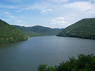
The New River is a river which flows through the U.S. states of North Carolina, Virginia, and West Virginia before joining with the Gauley River to form the Kanawha River at the town of Gauley Bridge, West Virginia. Part of the Ohio River watershed, it is about 360 miles (580 km) long.

Renison Bell is an underground tin mine and locality on the West Coast of Tasmania, Australia.

West Virginia Route 20 is a major north–south state highway in the U.S. state of West Virginia. The southern terminus of the route is at U.S. Route 52 in Bluewell, a small unincorporated suburb of Bluefield. The northern terminus is at West Virginia Route 7 three miles (5 km) east of New Martinsville. WV Route 20 is the longest state route in West Virginia.
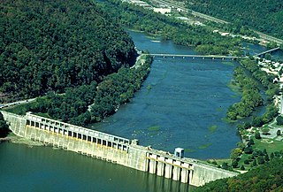
Bluestone Lake is a flood control reservoir located on the New River near Hinton, West Virginia. At its normal pool level, Bluestone Dam impounds a 10.7-mile (17.2 km) stretch of the New and its tributary, the Bluestone River. Normally approximately 2,040 acres (8.3 km2) in size, the lake can grow to over 36 miles (58 km) long at flood control pool. At higher water levels, the lake extends into Giles County, Virginia.

The Bluestone National Scenic River protects a 10.5-mile (16.9 km) section of the Bluestone River in Summers and Mercer counties of southern West Virginia. It was created 26 October 1988 under the Wild and Scenic Rivers Act and is protected by the National Park Service.
Pipestem Resort State Park is a 4,050-acre (1,640 ha) state park located in southern West Virginia, on the border between Mercer and Summers counties. The park was built with grants provided by the Area Redevelopment Administration of the U.S. Department of Commerce under the administration of President John F. Kennedy. It is located in the gorge of the Bluestone River.
Bluestone State Park is a state park in Summers County, West Virginia. The 2,154-acre (872 ha) park is located along the western shore of Bluestone Lake, an impoundment of the New River built and managed by the U.S. Army Corps of Engineers. The park and lake are named after the Bluestone River, that flows into the New River at the park.

Glen Jean is a census-designated place (CDP) in Fayette County, West Virginia, United States, near Oak Hill. As of the 2010 census, its population is 210.

Bluestone Wildlife Management Area is a wildlife management area in southern West Virginia surrounding Bluestone Lake and the New River. The section of the lake from just upstream of the Bluestone River to Bluestone Dam is in Bluestone State Park; the rest of the lake in West Virginia basin comprises Bluestone WMA. Altogether, the WMA comprises 18,019 acres (72.92 km2) of land and water.

Bellepoint was an unincorporated community located in Summers County, West Virginia. Bellepoint was later merged into Hinton; however, it had its own post office. See image below:
Ellison Ridge is an unincorporated community in Summers County, West Virginia, United States. Ellison Ridge is southwest of Hinton and southeast of Beckley.
Yards is an unincorporated community straddling the border between Tazewell County, Virginia and Mercer County, West Virginia, United States. Yards is located on the Bluestone River, 4 miles (6.4 km) northwest of Bluefield, Virginia. Yards had a post office on the Virginia side of the border from 1888 until May 28, 1994. The community was named for its railroad yards.
Eads Mill is an unincorporated community in Mercer County, West Virginia, United States. Eads Mill is located on the Bluestone River 5 miles (8.0 km) northwest of Athens.
Bluestone is an unincorporated community in Mercer County, West Virginia, United States. Bluestone is located along the Bluestone River and West Virginia Route 102 1 mile (1.6 km) south of Bramwell.

Skipwith is an unincorporated community in old Bluestone Township, Mecklenburg County, Virginia, United States. It is located between Chase City and Clarksville, west-northwest of the county seat at Boydton. The community was named for local members of the Skipwith family, related to colonial Virginia Skipwith families which began arriving from English baronial estates in the 1650s. The surname Skipwith is derived from Old English "sceap" (sheep) and Old Norse "vath". One ancient Skipwith coat of arms is blazoned "Argent, three bars Gules, in chief a greyhound courant Sable."

Wildwood, also known as the General Alfred Beckley Home, is a historic home located at Beckley, Raleigh County, West Virginia. The house is open as the Wildwood House Museum and was listed on the National Register of Historic Places in 1970.
Crane Creek is a stream in the U.S. state of West Virginia. It is a tributary of the Bluestone River.
Rich Creek is a stream in the U.S. state of West Virginia. It is a tributary of the Bluestone River.


