
The 6 Lexington Avenue Local and <6> Pelham Bay Park Express are two rapid transit services in the A Division of the New York City Subway. Their route emblems, or "bullets", are colored forest green since they use the IRT Lexington Avenue Line in Manhattan. Local service is denoted by a (6) in a circular bullet, and express service is denoted by a <6> in a diamond-shaped bullet. On the R62A rolling stock, this is often indicated by LEDs around the service logo to indicate local or express service to riders. The LEDs illuminate in a green circle pattern for 6 local trains and in a red diamond pattern for <6> trains.
The Hunts Point Avenue station is an express station on the IRT Pelham Line of the New York City Subway, served by the 6 train at all times and the <6> train on weekdays in the peak direction. It is located at Hunts Point Avenue and Southern Boulevard in the Longwood neighborhood in the Bronx.

The Whitlock Avenue station is a local station on the IRT Pelham Line of the New York City Subway. It is served by the 6 train at all times and is located at Whitlock Avenue and Westchester Avenue in the Foxhurst neighborhood of the Bronx.

The St. Lawrence Avenue station is a local station on the IRT Pelham Line of the New York City Subway. The station, served by the 6 train at all times, is located at the intersection of St. Lawrence Avenue and Westchester Avenue in the Soundview neighborhood of the Bronx.

The Parkchester station is an express station on the IRT Pelham Line of the New York City Subway. It is located above Hugh J. Grant Circle in the Parkchester neighborhood of the Bronx, where East 177th Street, Metropolitan Avenue, and Westchester Avenue intersect. The station is served by the 6 train at all times and the <6> train during weekdays in the peak direction.

The Castle Hill Avenue station is a local station on the IRT Pelham Line of the New York City Subway. Located at the intersection of Castle Hill and Westchester Avenues in the Castle Hill neighborhood in the Bronx, it is served by the 6 train at all times except weekdays in the peak direction, when the <6> train takes over.

The Zerega Avenue station is a local station on the IRT Pelham Line of the New York City Subway. Located at Zerega Avenue and Westchester Avenue in the Westchester Square neighborhood of the Bronx, it is served by the 6 train at all times except weekdays in the peak direction, when the <6> train takes over.
The Westchester Square–East Tremont Avenue station is a local station on the IRT Pelham Line of the New York City Subway. Located at the intersection of East Tremont and Westchester Avenues in the Westchester Square neighborhood of the Bronx, it is served by the 6 train at all times except weekdays in the peak direction, when the <6> train takes over.

The Middletown Road station is a local station of the IRT Pelham Line of the New York City Subway. Located at Middletown Road and Westchester Avenue in the Pelham Bay neighborhood of the Bronx, it is served by the 6 train at all times except weekdays in the peak direction, when the <6> train takes over.

The Buhre Avenue station is a local station on the IRT Pelham Line of the New York City Subway. Located at the intersection of Buhre and Westchester Avenues in the Pelham Bay neighborhood of the Bronx, it is served by the 6 train at all times except weekdays in the peak direction, when the <6> train takes over.

The Pelham Bay Park station is the northern terminal station of the IRT Pelham Line of the New York City Subway. Located across from Pelham Bay Park, at the intersection of the Bruckner Expressway and Westchester Avenue in the Pelham Bay neighborhood of the Bronx, it is served by the 6 train at all times, except weekdays in the peak direction, when the <6> serves it.

Soundview is a neighborhood on the Clason Point peninsula, on the southern section of the borough of the Bronx in New York City. Its boundaries, starting from the north and moving clockwise, are the Cross-Bronx Expressway to the north, White Plains Road to the east, Lacombe Avenue to the south, and the Bronx River to the west. The Bruckner Expressway bisects the neighborhood horizontally along the center and the Bronx River Parkway runs north to south. Soundview Avenue is the primary thoroughfare through Soundview.
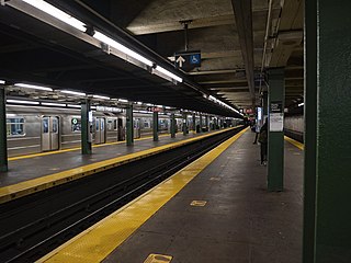
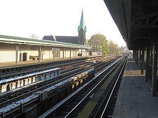
The IRT Pelham Line is a rapid transit line on the New York City Subway, operated as part of the A Division and served by the 6 and <6> trains. It was built as part of the Dual Contracts expansion and opened between 1918 and 1920. It is both elevated and underground with Whitlock Avenue being the southernmost elevated station. It has three tracks from the beginning to just south of the Pelham Bay Park terminal. The Pelham Line also has a connection to Westchester Yard, where 6 trains are stored, just north of Westchester Square–East Tremont Avenue.

Parkchester is a planned community and neighborhood originally developed by the Metropolitan Life Insurance Company and located in the central Bronx, New York City. The immediate surrounding area also takes its name from the complex. Its boundaries, starting from the north and moving clockwise, are East Tremont Avenue to the north, Castle Hill Avenue to the east, Westchester Avenue to the south, East 177th Street/Cross Bronx Expressway to the southwest, and White Plains Road to the west. Metropolitan Avenue, Unionport Road, and White Plains Road are the primary thoroughfares through Parkchester.

The Pelham Parkway station is a station on the IRT Dyre Avenue Line of the New York City Subway. Located at the intersection of Pelham Parkway North and the Esplanade in the Bronx, it is served by the 5 train at all times. This station was built as part of the New York, Westchester and Boston Railway (NYW&B), and opened in 1912. This station closed in 1937 with the NYW&B, but reopened in 1941 as a subway station after the portion of the line in the Bronx was purchased by New York City.

The Morris Park station is a station on the IRT Dyre Avenue Line of the New York City Subway served by the 5 train at all times. It is located at Paulding Avenue and the Esplanade in Morris Park, Bronx.

Castle Hill is a neighborhood located in the southeast section of the borough of the Bronx in New York City. Its boundaries are Waterbury Avenue and Westchester Avenue to the north, Westchester Creek to the east, the East River to the south, and White Plains Road to the west. Unionport is a subsection of Castle Hill, typically considered north of Lafayette Avenue.
Westchester Square is a residential neighborhood geographically located in the eastern section of the New York City borough of the Bronx. Its boundaries, starting from the north and moving clockwise are: East Tremont Avenue and Silver Street, Blondell Avenue and Westchester Creek to the east, Waterbury Avenue to the south and Castle Hill Avenue to the west. The main roadways through Westchester Square are East Tremont Avenue, Westchester Avenue and Williamsbridge Road.
Esplanade, also known as Esplanade Avenue, is a 0.8-mile (1.3 km) street with a series of green traffic medians in the Morris Park and Pelham Gardens neighborhoods of the Bronx in New York City. The street was constructed in 1912 atop a covered trench of the New York, Westchester and Boston Railway that was cut through a hill. Atop the hill, Esplanade intersects with Pelham Parkway, a road with its own series of green traffic medians designated as parkland.
