
Fairfax Avenue is a street in the north central area of the city of Los Angeles, California, United States. It runs from La Cienega Boulevard in Culver City at its southern end to Hollywood Boulevard in Hollywood on its northern end. From La Cienega Boulevard to Sunset Boulevard, it separates the Westside from the central part of the city along with Venice Boulevard, La Cienega Boulevard, Hauser Boulevard, San Vicente Boulevard, South Cochran Avenue, Wilshire Boulevard, 6th Street, Cochran Avenue, 4th Street, La Brea Avenue, Fountain Avenue and Sunset Boulevard.

Century City is a 176-acre neighborhood and business district in Los Angeles, California, United States. Located on the Westside to the south of Santa Monica Boulevard around 10 miles (16 km) west of Downtown Los Angeles, Century City is one of the most prominent employment centers in the Los Angeles metropolitan area, and its skyscrapers form a distinctive skyline on the city's westside.

Palms is a community in the Westside region of Los Angeles, California, founded in 1886 and the oldest neighborhood annexed to the city, in 1915. The 1886 tract was marketed as an agricultural and vacation community. Today it is a primarily residential area, with many apartment buildings, ribbons of commercial zoning and a single-family residential area in its northwest corner. As of the 2000 census the population of Palms was 42,545.
The Los Angeles Westside is an urban region in western Los Angeles County, California, United States. It has no official definition, but sources like LA Weekly and the Mapping L.A. survey of the Los Angeles Times place the region on the western side of the Los Angeles Basin south of the Santa Monica Mountains.

Mar Vista is a neighborhood on the Westside of Los Angeles, California. In 1927, Mar Vista became the 70th community to be annexed to Los Angeles. It was designated as an official city neighborhood in 2006.
West Los Angeles is an area within the city of Los Angeles, California, United States. The residential and commercial neighborhood is divided by the Interstate 405 freeway, and each side is sometimes treated as a distinct neighborhood, mapped differently by different sources. Each lies within the larger Westside region of Los Angeles County.

Rancho Park is a residential neighborhood in the Westside of the city of Los Angeles, California with mostly single family homes and tree lined streets. The community is nestled between West Los Angeles and Cheviot Hills. This enclave draws young professionals and families and is home to residents working in a variety of professional occupations. History proves the neighborhood was once a part of Westwood until Olympic Blvd. was placed dividing the area North and South. The Southern section, now known as Rancho Park, felt cut off from its North side lobbying for its own identity in the 1930s.

Del Rey is a neighborhood in the Westside of Los Angeles, surrounded on three sides by Culver City, California. Within it lie a police station, the largest public housing complex on the Westside, a public middle school and six public elementary schools. It is served by a neighborhood council and a residents association. Del Rey, with a 32,000+ population, has a large number of military veterans.

El Sereno is a Los Angeles neighborhood in the Eastside Los Angeles region of Los Angeles County, California.

Westside Village is a neighborhood on the west side of Los Angeles, California.

LaFayette Square is a historic semi-gated neighborhood in the central region of Los Angeles, California.

The Orcutt Ranch Horticulture Center, formally known as Rancho Sombra del Roble, is a Los Angeles Historic-Cultural Monument located in the West Hills section of Los Angeles, California, USA.
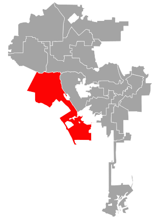
Los Angeles's 11th City Council district is one of the fifteen districts in the Los Angeles City Council. It is currently represented by Democrat Traci Park since 2022, who succeeded Mike Bonin after his retirement.
Paul Whitney Trousdale Jr. was an American real estate developer. He is best known for developing the Trousdale Estates in Beverly Hills, California. He built over 25,000 homes in Southern California.

Trousdale Estates is a neighborhood of Beverly Hills, California, located in the foothills of the Santa Monica mountains. It was developed in the 1950s and 1960s and is named after Paul Trousdale, a real estate developer.
Allen Siple (1900–1973) was an American architect, working in Southern California from the 1930s to 1960s.
The Mar Vista Community Council is a city-sanctioned neighborhood council of the City of Los Angeles serving six districts or "zones," collectively referred to as Mar Vista. It is in the Westside region of Los Angeles.

Castle Heights is a neighborhood on the Westside of the city of Los Angeles, California.


