Westgate (Columbus, Ohio)

Last updated
Westgate
Allen.1749 Westgate 22.jpg
Westgate Neighborhood Entrance
Westgate (Columbus, Ohio)
Interactive map of the neighborhood
Coordinates: 39°56′48″N83°04′55″W / 39.946721°N 83.082003°W / 39.946721; -83.082003
Country United States
State Ohio
County Franklin
City Columbus

Westgate is a community within the Hilltop area of Columbus, Ohio. It was partially constructed on land that formerly housed the American Civil War Camp Chase and a Confederate prison. After the Civil War, the land was purchased by Joseph Binns and his associates with the intent to start a Quaker community. These plans failed to materialize and the land was developed as a "streetcar suburb" in the 1920s. [1] Located 4 miles (6.4 km) west of downtown, the neighborhood is home to Westgate Park and Recreation Center, Westgate Alternative Elementary School, St. Mary Magdalene Church and school, and Parkview United Methodist Church. 4,500 residents live within the Westgate boundaries, most in single family houses. [2]

Contents

The Columbus Dispatch named Westgate one of the most affordable neighborhoods in the City of Columbus in October 2008. [1]

Westgate is located 4 miles (6.4 km) west of Downtown Columbus and is bounded by W. Broad Street to the north, Wilson rd to the west, Sullivant Avenue to the south, and Hague to the east. [3]

History

Camp Chase

One third of Westgate sits on land that was formerly Camp Chase during the Civil War. This camp was opened in 1861 and served as training grounds for the Union Army. It is named after the former governor of Ohio and Secretary of the Treasury, Salmon P. Chase. Eventually it was converted to a prisoner of war camp to hold captured Confederate soldiers. At the beginning it held 250 prisoners, but after many expansions it became large enough to house 9,146 men. The camp was emptied of all prisoners on July 5, 1865. [2] [4]

Camp Chase Cemetery

Camp Chase Camp chase 2.jpg
Camp Chase

The only thing remaining from Camp Chase today is the cemetery. The cemetery is one of only two remaining federal properties from the Civil War that is located in Columbus. Memorial services began in 1895, and continue to the present day. The headstones were placed in the cemetery between 1906 and 1908 by a marble company in Nelson, Georgia. These headstones do not mark individual graves, but rather exist to represent those that died. Residents began having an annual bean dinner around the cemetery in the 1930s in order to remember and honor those that gave their life in the war. This event continues today and takes place on the last Saturday in June. The Hilltop Historical Society holds an annual memorial service at the cemetery on the second Sunday of June. This event includes reenactment soldiers and characters from the time. The cemetery is currently on the National Registrar of Historic Places and is maintained by the Dayton National Cemetery. [2] [4]

Short Creek Quarterly Meeting of the Quaker Church

Shortly after the Civil War, members of the Short Creek Quarterly meeting of the Quaker Church showed their interest in the ensuing auction of a 463.5-acre plot of land in the Hilltop area. Their intention was to use this land to create their dream Quaker settlement. Five Quaker men came to the site in 1870 in order to determine whether or not it met their needs. They determined this land to be suitable and consequently returned to purchase it in 1872. This purchase took place on January 23 and cost $87.50 per acre. Many notable Quakers moved here such as John Cowgill, John Hussey, and William H. Harris. Many of the streets in Westgate today are named for these Quaker settlers. [2] [4]

Founding

In 1905, after the end of the Civil War and subsequent purchase of the Camp Chase property by Quaker settlers, the land was sold to a real estate agency and subdivided for housing. Building of homes began in the 1920s and by the mid-1920s Westgate was established as one of Columbus' streetcar suburbs. [1] [2]

Structures and landmarks

Westgate Shelterhouse Allen.1749 Westgate 6.jpg
Westgate Shelterhouse

Westgate Park is a 46.3-acre city park located in the center of the Westgate neighborhood. It features a fishing pond, a rain garden, and a playground, as well as picnic areas, an open shelterhouse, a walking trail, and a wooded area. [4] The Westgate Shelterhouse is available by reservation through the City of Columbus Recreation and Parks department. It accommodates 180 people and provides heating and air conditioning, a bridal changing room, a covered porch, a fireplace, a foyer, a kitchen, restrooms, tables and chairs, and handicap access. [5]

Westgate Community Recreation Center has amenities including an art room, an auditorium, a ceramics room, a crafts room, a dance room, a fitness room, a game room, a gymnasium, a gymnastics room, a handball court, a kitchen, a lobby area, meeting rooms, a volleyball court, and a weight room. [6] Athletic fields and courts for tennis, basketball, baseball, soccer, football, etc. are located outside of the facility.

Parkview United Methodist Church Allen.1749 Westgate 4.jpg
Parkview United Methodist Church

Westgate United Methodist Church is a medium-sized church located at 61 South Powell Avenue. It sits immediately north of West High school. Their mission is to help people to find their way back to God. [7] They have been offering regular weekly services since their foundation in 1927. [8]

Parkview United Methodist Church is centrally located just north of Westgate park. This church was very important in the plan for the neighborhood. This can be seen in the multiple streets that converge around it as well as in its prominent placement in relation to the park. It was constructed in 1941. [9]

Events

Summer Jam West is a free arts and music festival held annually in Westgate Park on the second Saturday in July. There are live bands, local art for sale, hand crafted items for sale, free face painting for the kids and a free art zone. Summer Jam is open to all. The focus is on bringing art and music to the Hilltop. [10]

Hilltop Bean Dinner is an annual event held in late June where the Hilltop community congregates in Westgate park to share a meal. This event consists of music, art vendors, historic car shows, and most importantly the bean dinner. This event attracts many people from outside of the Westgate and greater Hilltop area as it is one of the primary annual events in the area. [11]

The Westgate Home and Garden Tour is held on the second Saturday in June, from 2:00 – 6:00 PM.

The Westgate Farmers Market is held on the first and third Saturdays of each month, June through October, from 9:00 AM – 12:00 PM at the West Gate Masonic Lodge. [12]

Education

Westgate Alternative Elementary School 061212 Westgate School--Columbus, Ohioi (5).jpg
Westgate Alternative Elementary School

Westgate Alternative Elementary School is a public kindergarten-through-5th-grade elementary school located at 3080 Wicklow Road in Westgate. Its mission statement reads: "Each student is highly educated, prepared for leadership and service, and empowered for success as a citizen in a global community." [13] The school's standardized test performance ranks it 962nd among the 1596 Ohio public elementary schools and 7th among the 74 ranked elementary schools in the Columbus City School District. [14]

Saint Mary Magdalene School is a private elementary school that teaches grades kindergarten through 8th. It was established in 1928 and has continually taught students since. The school consists of six buildings which are centrally located on a main campus. It is supported by the Ohio Catholic School Accreditation Association and the State of Ohio. [15]

West High School is a public high school that teaches grades 9–12 and is located at 179 S Powell Ave, Columbus, OH. It shares the same mission statement as Westgate Alternative Elementary School. Their colors are buff and brown and their mascot is the cowboy. [16] In 2014 the school was ranked 708th out of 756 high schools for standardized tests as its average reading score was 76.3. This is up from 2012 when the school was ranked 733rd and had an average reading test score of 69.5. [17]

Residential

Cottage Allen.1749 Westgate 13.jpg
Cottage

Westgate is a very popular neighborhood for first time home buyers because of its location, aesthetic style, and low cost. In 2008 the average cost of a house in Westgate was 120,000 dollars. The majority of the residences in Westgate are single family houses that are owned by their occupants. The typical Westgate house is a cottage style with 2–3 bedrooms and is no taller than two stories. Most houses have either a brick or plaster facade as well as roofs with multiple peaks. This design helps to accentuate the homey feel of the neighborhood. [1] The uniqueness of each home in Westgate as well as the community's emphasis on façade and yard aesthetics has attracted residents who enjoy the freedom to use original and eclectic design styles. [18]

Westgate has been described as "a nice neighborhood, with a family oriented atmosphere." [1] Westgates residents are very diverse socially but tend to be middle class and young. Currently there is a new wave of people moving to Westgate who are in search of a Clintonville home at a cheap price. Westgate provides these home buyers the perfect option because each of its houses is unique and full of character. The main problem that residents face is the public school system. Both the elementary and high school in Westgate are ranked in the bottom half of public schools in Ohio. Due to this many families move out of Westgate when their kids become old enough to start attending school. The residents of Westgate are actively trying to improve their community as seen by their successful attempt in forming a neighborhood association. Westgate is a quaint, young, unique neighborhood that provides a multitude of benefits to its residents. [1]

The Westgate Neighbors' Association is a non-profit community civic organization formed in February 2008. It is made up of residents in and around the Westgate neighborhood to improve livability in the neighborhood. [2]

Related Research Articles

<span class="mw-page-title-main">Bexley, Ohio</span> City in Ohio, United States

Bexley is a suburban city in Franklin County, Ohio, United States. The population was 13,928 at the 2020 census. Founded as a village, the city of Bexley is a suburb of Columbus, the Ohio state capital, situated on the banks of Alum Creek next to Driving Park and Wolfe Park, just east of the Franklin Park Conservatory. It is horizontally bisected by the National Road, serving as a reminder of Bexley's origins as a merger between the prestigious Bullitt Park neighborhood to the north, and the Lutheran college community of Pleasant Ridge to the south.

<span class="mw-page-title-main">Ashburn, Chicago</span> Community area in Chicago

Ashburn, one of Chicago's 77 community areas, is located on the south side of the city. Greater Ashburn covers nearly five square miles. The approximate boundaries of Ashburn are 72nd Street (north), Western Avenue (east), 87th Street (south) and Cicero Avenue (west).

<span class="mw-page-title-main">Victorian Village</span> Neighborhood of Columbus in Franklin, Ohio, United States

Victorian Village is a neighborhood in Columbus, Ohio, United States, north and near west of downtown. It is an established neighborhood built when a streetcar line first ran along Neil Avenue around 1900 with a fair number of established trees for an urban setting. To preserve, protect and enhance the unique architectural and historical features, the Victorian Village Historic District was established in 1973. Columbus Monthly named this neighborhood the top place to live for Arts and Entertainment, with fun right around the corner in the Short North as its neighborhood hangout.

<span class="mw-page-title-main">Brightmoor, Detroit</span> Neighborhood of Detroit, Michigan

Brightmoor is a neighborhood located in Detroit, Michigan, near the northwest border of the city. Brightmoor is defined by the Brightmoor Alliance as being bordered by Puritan Avenue to the north, the CSX railway to the south, Evergreen Road to the east, and Outer Drive West, Dacosta Street, and Telegraph Road to the west. However, the demographics given here for the neighborhood are the city's statistical Master Plan Neighborhood area, which consists of eight census tracts that includes some areas outside of the Alliance's boundaries, but does not include some areas within its boundaries.

<span class="mw-page-title-main">Camp Chase</span> Military camp in Columbus, Ohio, USA

Camp Chase was a military staging and training camp established in Columbus, Ohio in May 1861 after the start of the American Civil War. It also included a large Union-operated prison camp for Confederate prisoners during the American Civil War.

<span class="mw-page-title-main">Hilltop (Columbus, Ohio)</span> Neighborhood of Columbus in Franklin, Ohio, United States

Hilltop is one of the largest neighborhoods in Columbus, Ohio, located west of Franklinton and Downtown. The Greater Hilltop area contains newer and historic neighborhoods, schools, various stores, industrial areas, and recreational facilities. The development pattern is considered a distinct suburb. The majority of the area is predominantly single family residential.

<span class="mw-page-title-main">Franklinton (Columbus, Ohio)</span> Neighborhood in Columbus, Ohio

Franklinton is a neighborhood in Columbus, Ohio, just west of its downtown. Settled in 1797, Franklinton is the first American settlement in Franklin County, and was the county seat until 1824. As the city of Columbus grew, the city annexed and incorporated the existing settlement in 1859. Franklinton is bordered by the Scioto River on the north and east, Harmon Avenue on the east, Stimmel Road and Greenlawn Avenue on the south, and Interstate 70 on the west. Its main thoroughfare is West Broad Street, one of the city's two main roads.

<span class="mw-page-title-main">Olentangy West (Columbus, Ohio)</span> Neighborhood in Columbus in Franklin, Ohio, United States

Olentangy West is a neighborhood approximately 5 miles (8 km) northwest of downtown Columbus, Ohio, United States. Also called West Olentangy, it is generally bordered by West Henderson Road on the north, the Olentangy River and Clintonville on the east, Kinnear Road on the south, and Upper Arlington on the west. The area is primarily residential, although the large Riverside Methodist Hospital and the headquarters for Chemical Abstracts Service are located within its boundaries. Additionally, the west campus of Ohio State University is located within the southern boundary of the area.

West Columbus, sometimes referred to as westside or the West Side, is a neighborhood in Columbus, Ohio, United States. Unlike other Columbus neighborhoods, it is a broad geographical term used by locals rather than a subdivision or suburb. West Columbus is defined as the entire southwest side of Columbus, bordered on the north by interstates 70 and 670, within Interstate 71 on the east, and on the south and west by the city limits that reach several miles to the outside of the I-270 outerbelt. It covers the ZIP Codes 43223, 43204, 43228, and 43222.

Columbus, the state capital and Ohio's largest city, has numerous neighborhoods within its city limits. Neighborhood names and boundaries are not officially defined. They may vary or change from time to time due to demographic and economic variables.

<span class="mw-page-title-main">Driving Park</span> Neighborhood in Columbus, Ohio, U.S.

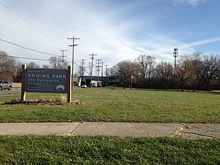
Driving Park is an urban residential area on the Near East Side of Columbus, Ohio just south of Interstate 70. Mainly a middle-class, predominantly African American neighborhood, Driving Park and its surrounding neighborhoods consist of an area of 17,730 residents. Driving Park received its name from its historic past as a large racing complex, first for horses and later for automobiles.

<span class="mw-page-title-main">Goodale Park</span> Park in Columbus, Ohio, U.S.

Goodale Park is a public park in the Victorian Village area of Columbus, Ohio. It was donated to the city in 1851 by Lincoln Goodale. For a few months during the Civil War, it was a staging area for Union troops known as Camp Jackson. ComFest, a large, free, multi-day, non-corporate, music and arts annual festival, is held in the park in June.

<span class="mw-page-title-main">Old North Columbus</span> Neighborhood in Columbus, Ohio

Old North Columbus is a neighborhood located just north of the Ohio State University in Columbus, Ohio. It was founded in 1847 where, at the time, it was a stand-alone city out of the confines of Columbus until it was incorporated into the City of Columbus in 1871. In its early years the city was a popular stagecoach stop with people traveling from Worthington to Columbus. Today Old North Columbus is popular for its local music and its unique "untouched architecture" which is reminiscent of its old roots.

<span class="mw-page-title-main">Glen Echo (Columbus, Ohio)</span> United States historic place

Glen Echo is a neighborhood located in the far northern part of the University District in Columbus, Ohio. The area was listed on the National Register of Historic Places in 1997. The name Glen Echo refers to Glen Echo Ravine, which runs along the northern edge of the neighborhood. Principal streets in the area are Glen Echo Drive, Summit Street, Glenmawr Avenue, North Fourth Street, Arcadia, Cliffside Drive, and more. One street, Parkview Drive, was platted in the ravine basin, but was later abandoned.

Allandale, Austin, Texas is a neighborhood in North Central Austin, in the U.S. State of Texas known for its large lots, mature trees, and central location.

<span class="mw-page-title-main">Woodland Park (Columbus, Ohio)</span> Neighborhood of Columbus in Franklin, Ohio, United States

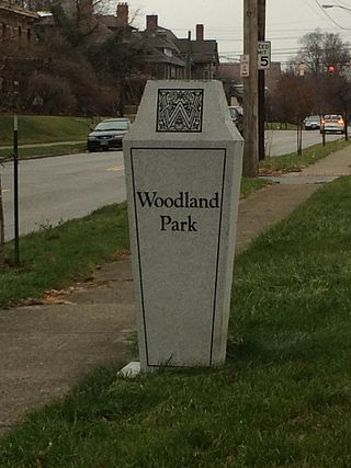
Woodland Park is a residential neighborhood located in the Near East Side of Columbus, Ohio that houses approximately 1,500 residents. The neighborhood was previously home to such figures as artist Emerson Burkhart, cartoonist Billy Ireland, and judge William Brooks. Established in the early 20th century, Woodland Park has grown from its planned neighborhood roots into a neighborhood that contains various faith communities, schools, sources of entertainment and recreation, and borders an extension of the Ohio State University medical center.

<span class="mw-page-title-main">Camp Chase Trail</span>

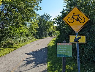
The Camp Chase Trail is a paved multi-use trail in Madison and Franklin counties in the U.S. state of Ohio. It serves as the Southwest Columbus segment of the 326-mile (525 km) Ohio to Erie Trail. The entire length of the Camp Chase Trail is part of the Great American Rail-Trail, U.S. Bicycle Route 21 and U.S. Bicycle Route 50.

<span class="mw-page-title-main">Briggsdale (Columbus, Ohio)</span>

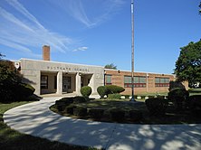
Briggsdale is a neighborhood of Franklin County in the city of Columbus, Ohio. The neighborhood is on the west/southwest side of the city within the Hilltop area. The area was first settled and founded by the family of Joseph M. Briggs, after whom the neighborhood was named. Joseph Briggs was an active figure in the early years of the township and county operations. The Briggsdale Methodist church was founded with his help, and it now exists as the New Horizons Methodist Church. The present-day Briggsdale neighborhood is located near the historical Green Lawn Cemetery to the north as well as Briggs High School to the west.

<span class="mw-page-title-main">Franklin Park (Columbus, Ohio)</span> Place

Franklin Park is a neighborhood located on the Near East Side of Columbus, Ohio. Both the historic neighborhood and landmark, the Franklin Park Conservatory and Botanical Gardens, are named after the 88-acre park.

<span class="mw-page-title-main">Southern Orchards</span> Place

Southern Orchards is an established neighborhood near the south side of Columbus, Ohio. It is located immediately southeast of downtown and is the 23rd most walkable neighborhood in Columbus with 3,538 residents. The neighborhood is the target of revitalization and beautification largely due to its anchor institution Nationwide Children's Hospital and a renewed interest in urban living in the city's core. Since 2008, more than 90 properties have been improved through the hospital’s Healthy Homes program and continued revitalization is occurring along the major streets of Livingston and Parsons Avenues as the city moves to reconnect downtown to its surrounding neighborhoods.

References

  1. 1 2 3 4 5 6 "An Affordable Oasis". Columbus Dispatch. 2008-10-01. Retrieved 2014-12-02.
  2. 1 2 3 4 5 6 "Westgate Neighbor's Association". YouTube . 2011-10-14. Retrieved 2014-11-12.
  3. "Westgate". WOSU. 25 July 2013. Retrieved 2014-12-09.
  4. 1 2 3 4 "Westgate Park". westgateneighbors.org. Westgate Neighbors Association. Retrieved 2014-11-11.
  5. "Westgate Shelterhouse". columbus.gov. City of Columbus, Ohio. 2014. Retrieved 2014-11-11.
  6. "Westgate Community Recreation Center". columbus.gov. City of Columbus, Ohio. 2014. Retrieved 2014-11-11.
  7. "About Us". Westgate United Methodist Church. Retrieved 2014-12-09.
  8. "Westgate United Methodist Church". Manta. Retrieved 2014-12-02.
  9. "Parkview United Methodist Church". Manta. Retrieved 2014-12-02.
  10. "Summer Jam". summerjamwest.org. Summer Jam West. 2013. Retrieved 2014-11-11.
  11. "2014 Historic Hilltop Bean Dinner". Hilltop Business Association. Retrieved 2014-12-09.
  12. "Westgate Farmers Market". www.westgatefarmersmarket.com. Westgate Farmers Market. 2020. Retrieved 2020-03-23.
  13. "About Us". Westgate Alternative Elementary School. 2014. Retrieved 2014-11-12.
  14. "Westgate Alternative Elementary School". School Digger. Schooldigger.com. 2014. Retrieved 2014-11-12.
  15. "About Saint Mary Magdalene Catholic School - Columbus, Ohio". Saint Mary Magdalene School. Retrieved 2014-12-01.
  16. "About Us". West High School. Retrieved 2014-12-01.
  17. "West High School". School Digger. 2014. Retrieved 2014-12-01.
  18. Evans, Anne (2011-01-02). "At Home: Eclectic Style in Westgate". ColumbusUnderground.com. Retrieved 2014-12-15.