Westleigh, Greater Manchester

Last updated

Westleigh
St Peter's Church, Leigh.jpg
History
  Created Middle Ages
  Abolished1875
  Succeeded byLeigh Urban District,
Status Township

Westleigh, a suburb of Leigh, Greater Manchester, England, is one of three ancient townships, Westleigh, Bedford and Pennington, that merged in 1875 to form the borough of Leigh.

Contents

History

Toponymy

The name Westleigh derives from the Old English and refers to the locality's relative position to Leigh. The name Leigh is derived from leah, meaning originally a "wood" then a "clearing" and finally a "meadow". [1] [2] It was recorded as Westeley in 1237, Westlegh in 1238 and Westlay in Legh in 1292. [3]

Manor

The early history of Westleigh is closely involved with 'the church of Westley in Leigh', dedicated to St Peter on the Westleigh-Pennington boundary. This church was the centre of a large ecclesiastical parish, and after the Reformation dedicated to St Mary the Virgin, and is now the parish church in Leigh. The earliest recorded Lords of the Manor were the Westleigh family. They were followed by the Urmstons who held the manor for several centuries until the failure of the male line. Daughters of Richard Urmston married into the Heaton, Shuttleworth, and Bradshaw families who sold the manor to the Athertons and Hiltons. [4] The manor eventually came into the Marsh family who made money from the silk and textile industries. The Marshes were benefactors of the township, giving money for the original swimming baths and Marsh Gymnasium as well as bequests to the Parish Church. Westleigh Old Hall was left to Leigh Corporation, the house demolished and the grounds became Marsh playing fields.

Industry

Locomotive at Bickershaw Colliery, Leigh NCB Hunslet Austerity 63000326 at Bickershaw Colliery (5).jpg
Locomotive at Bickershaw Colliery, Leigh

There were drift mines in Westleigh as early as the 12th century and in Leigh by 1851 there were 17 pits mainly in Westleigh each employing less than 10 colliers. The coal industry developed rapidly after 1870 with the onset of deep mines. In 1872 Ackers and Whitley began to develop the Bickershaw Colliery in neighbouring Pennington, accessed off Plank Lane, Westleigh which by 1970 employed 1,489 men who in that year produced 1,716,479 tons of coal. In 1896 the Westleigh pits of the Wigan Coal and Iron Company included Priestners which employed 387 underground and 70 on the surface, Snapes, and the Sovereign which had 180 underground and 68 on the surface. [5] Parsonage Colliery was sunk by the Wigan Coal and Iron Company between 1913 and 1920 with shafts exceeding 1,000 yards in depth. [6]

The cotton industry which replaced a domestic system of handloom weaving became more important with the building of Kirkhall Lane Mills (Westleigh New Mill) in 1836. Victoria Mills off Kirkhall Lane were built by James and John Hayes between 1856 and 1887 and Firs Mills were built by Tunnicliffe and Hampson. [6]

Governance

Westleigh was a township in the ancient ecclesiastical parish of Leigh in the hundred of West Derby in Lancashire. [4] Under the terms of the Poor Law Amendment Act 1834 Westleigh formed part of the Leigh Poor Law Union, which was established on 26 January 1837 and responsible for an area covering the whole of the ancient parish of Leigh and part of Winwick. There were workhouses in Pennington, Culcheth, Tyldesley, and Lowton, but they were replaced by Leigh Union workhouse at Atherleigh in the 1850s. [7] The Local Government Act of 1858, and the Public Works (Manufacturing Districts) Act, 1863, were adopted by the township in 1863. In 1875, the district was dissolved and merged into the Leigh Local Board, which became an urban district council under the Local Government Act, 1894 and incorporated in the Municipal Borough of Leigh. The population in 1901 was 16,177. [3]

Geography

Westleigh occupies the north west portion of Leigh, covering 1,882½ statute acres. [8] The ground rises in undulations from 75 feet above sea level in the south to 150 feet in the north and northwest. The Westleigh Brook crosses the township from north to south and joins with the Hey or Pennington Brook, flowing from the west. The geological formation consists of coal measures in the north, under the Permian rocks which outcrop from Westleigh village to Westleigh Heath and Strange Common. To the south east the formation consists of the pebble beds of the new red sandstone series. [3] There are several small flashes, small lakes created in the 20th century by coal mining subsidence and flooding.

Transport

The Wigan and Leigh branch of the Leeds and Liverpool Canal crosses the south of the township from west to east, and the road from Hindley to Atherton (A577) crosses to the north of Westleigh with a branch road to Leigh running south. [3] The Bolton and Leigh Railway line reached Westleigh in March 1830 and was extended across the Leeds and Liverpool Canal to Kenyon Junction on the Liverpool and Manchester Railway. Leigh Station on the Bolton and Leigh Railway at Westleigh was opened to passengers in June 1831. [9] The line of the railway is now the route of the A579 road. The Manchester–Southport line of the London and North Western Railway crossed the northern part of Westleigh.

Religion

The foundation stone of St. Paul's Westleigh, a chapel of ease of Leigh Parish Church, was laid in June 1846 and the church consecrated in October 1847. It is built in the decorated style and stands on land given by Lord Lilford, who also provided the stone used to build it. Westleigh St Paul's became a district chapelry in the parish of Leigh in 1881. [3]

Westleigh St Peter was founded 1881 is on Firs Lane. It is a Grade II* listed building by Paley and Austin, built in brick with red sandstone dressings. [10]

A growing Roman Catholic population in the area led to the building of Our Lady of the Rosary in Plank Lane in 1879, Twelve Apostles in 1879, and Sacred Heart in 1929. [11]

Related Research Articles

<span class="mw-page-title-main">Adlington, Lancashire</span> Town and civil parish in Lancashire, England

Adlington is a village and civil parish in Lancashire, England, near the West Pennine Moors and approximately three miles south of Chorley. It became a separate parish in 1842 then grew into a township around the textile and coal mining industries until these closed in the 1960s. It had a population of 5,270 at the 2001 census, but in the last decade this has risen by over 2,000 more people to 7,326. The measured population at the 2011 Census was 6,010. The Leeds and Liverpool Canal runs through the village and is host to White Bear Marina which is the largest marina on the Leeds and Liverpool Canal.

<span class="mw-page-title-main">Ashton-in-Makerfield</span> Town in North West England

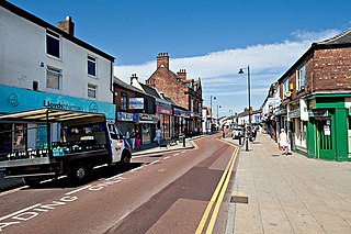
Ashton-in-Makerfield is a market town in the Metropolitan Borough of Wigan, Greater Manchester, England, 4 miles (6.4 km) south of Wigan. In 2011, it had a population of 28,762.

<span class="mw-page-title-main">Leigh, Greater Manchester</span> Town in the Metropolitan Borough of Wigan

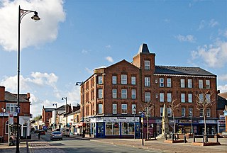
Leigh is a town in the Metropolitan Borough of Wigan, Greater Manchester, England, on low-lying land northwest of Chat Moss.

<span class="mw-page-title-main">Coppull</span> Human settlement in England

Coppull is a village and civil parish in Lancashire, England. It is part of the Borough of Chorley, lies around 300 feet (91 m) above sea level. Its population is around 8,000, having been counted at 7,959 in the 2011 Census. It is bounded by Whittle Brook, Clancutt Brook, the River Yarrow, Eller Brook, Hic-Bibi Brook and Stars Brook. Coppull is located between Chorley and Standish, Greater Manchester, to the east of the A49 road near Charnock Richard.

<span class="mw-page-title-main">Hindley, Greater Manchester</span> Human settlement in England

Hindley is a town within the Metropolitan Borough of Wigan in Greater Manchester, England. It is three miles (4.8 km) east of Wigan and covers an area of 2,580 acres (1,044 ha). Within the boundaries of the historic county of Lancashire, Hindley borders the towns and villages of Ince-in-Makerfield, Aspull, Westhoughton, Atherton and Westleigh in the former borough of Leigh. In 2001, Hindley had a population of 23,457, increasing to 28,000 at the 2011 Census. It forms part of the wider Greater Manchester Urban Area.

<span class="mw-page-title-main">Atherton, Greater Manchester</span> Town in Greater Manchester, England

Atherton is a town in the Metropolitan Borough of Wigan in Greater Manchester, England and historically part of Lancashire. The town, including Hindsford, Howe Bridge and Hag Fold, is 5 miles (8.0 km) south of Bolton, 7 miles (11.3 km) east of Wigan, and 10 miles (16.1 km) northwest of Manchester. From the 17th century, for about 300 years, Atherton was known as Chowbent, which was frequently shortened to Bent, the town's old nickname. During the Industrial Revolution, the town was a key part of the Manchester Coalfield.

<span class="mw-page-title-main">Standish, Greater Manchester</span> Human settlement in England

Standish is a village in the Metropolitan Borough of Wigan, Greater Manchester, England. Within the boundaries of the historic county of Lancashire, it is on the A49 road between Chorley and Wigan, near Junction 27 of the M6 motorway. The population of the village was 13,278 in the 2011 census.

<span class="mw-page-title-main">Haigh, Greater Manchester</span> Village in Greater Manchester, England

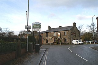
Haigh is a village and civil parish in the Metropolitan Borough of Wigan, Greater Manchester, England. Historically part of Lancashire, it is located next to the village of Aspull. The western boundary is the River Douglas, which separates the township from Wigan. To the north, a small brook running into the Douglas divides it from Blackrod. At the 2001 census it had a population of 594.

<span class="mw-page-title-main">Shevington</span> Village and civil parish in [[Greater Manchester]], England

Shevington is a village and civil parish within the Metropolitan Borough of Wigan, Greater Manchester, England. The population of the Wigan ward called Shevington and Lower Ground had increased to 11,482 at the 2011 Census.

<span class="mw-page-title-main">Astley, Greater Manchester</span> Human settlement in England

Astley is a village in the Metropolitan Borough of Wigan, Greater Manchester, England. Within the boundaries of the historic county of Lancashire, it is crossed by the Bridgewater Canal and the A580 East Lancashire Road. Continuous with Tyldesley, it is equidistant from Wigan and Manchester, both 8.3 miles (13.4 km) away. Astley Mosley Common ward had a population of 11,270 at the 2011 Census.

<span class="mw-page-title-main">Tyldesley</span> Market town in Greater Manchester, England

Tyldesley is a market town in Metropolitan Borough of Wigan in Greater Manchester, England. Within the boundaries of the historic county of Lancashire, it is north of Chat Moss near the foothills of the West Pennine Moors, 8 miles (12.9 km) southeast of Wigan and 9 miles (14.5 km) northwest of Manchester. At the United Kingdom Census 2001, the Tyldesley built-up area subdivision, excluding Shakerley, had a population of 16,142.

<span class="mw-page-title-main">St Mary the Virgin's Church, Leigh</span> Church in Greater Manchester, England

The Parish Church of St Mary the Virgin is a Church of England parish church in Leigh, Greater Manchester, England. It is a member of the Salford & Leigh deanery in the archdeaconry of Salford, diocese of Manchester. It is recorded in the National Heritage List for England as a designated Grade II* listed building.

Leigh was a railway station in Bedford, Leigh, Greater Manchester, England, United Kingdom, on the London and North Western Railway. Leigh was in the historic county of Lancashire. Its station opened as Bedford Leigh in 1864, was renamed Leigh & Bedford in 1876 and Leigh in 1914. The station closed in 1969.

Kenyon Junction was a railway station at Kenyon near Culcheth in Warrington, England. The station was built at the junction of the Liverpool and Manchester Railway and the Kenyon and Leigh Junction Railway. It was situated in the historic county of Lancashire. The station opened in 1830 as Bolton Junction and closed to passengers on 2 January 1961 before closing completely on 1 August 1963. The junction fell out of use when the line serving Leigh was closed in 1969.

Pennington railway station served Pennington, Leigh, Greater Manchester, England on the Bolton and Leigh Railway. It was situated within the historic county of Lancashire.

Westleigh or West Leigh was a station in Leigh, Greater Manchester, England on the Bolton and Leigh Railway line. Westleigh was situated within the historic county of Lancashire. Its station opened in 1831 and closed in 1954.

<span class="mw-page-title-main">Bedford, Greater Manchester</span> One of three townships that merged to form Leigh, England

Bedford, a suburb of Leigh, Greater Manchester is one of three ancient townships, Bedford, Pennington and Westleigh, that merged in 1875 to form the town of Leigh. Historically, Bedford was in Lancashire.

<span class="mw-page-title-main">Pennington, Greater Manchester</span>

Pennington, a suburb of Leigh, Greater Manchester is one of six townships in the ancient ecclesiastical parish of Leigh, that with Westleigh and Bedford merged to form the town of Leigh in 1875. The township of Pennington covered most of Leigh's town centre.

The Kenyon and Leigh Junction Railway (K&LJR) was constructed to link the Bolton and Leigh Railway (B&LR), which terminated at the Leigh Branch of the Leeds and Liverpool Canal, with the Liverpool and Manchester Railway (L&MR) at Kenyon.

References

Notes

  1. Mills (1998), p. 218.
  2. Mills (1998), p. xx.
  3. 1 2 3 4 5 Farrer, William; Brownbill, J, eds. (1907), "Westleigh", A History of the County of Lancaster: Volume 3, British History Online, pp. 421–426, retrieved 23 December 2009
  4. 1 2 Lewis, Samuel (1848), "Westleigh", A Topographical Dictionary of England, British History Online, pp. 517–519, retrieved 17 March 2010
  5. Wigan Coal & Iron Co. Ltd., Durham Mining Museum, retrieved 7 February 2011
  6. 1 2 LeighTownTrailPart1 (PDF), Wigan.gov.uk, archived from the original (PDF) on 29 September 2011, retrieved 17 May 2010
  7. Leigh, workhouses.org.uk, retrieved 17 May 2010
  8. Westleigh Township Boundaries, genuki.org.uk, retrieved 5 May 2010
  9. Westleigh Station, subbrit.org.uk, retrieved 5 May 2010
  10. Historic England. "Westleigh St Peter (1068481)". National Heritage List for England . Retrieved 5 May 2010.
  11. "Leigh". genuki.org.uk. Retrieved 5 May 2010.

Bibliography

53°30′25″N2°31′55″W / 53.507°N 2.532°W / 53.507; -2.532