Whinlatter

Last updated

Whinlatter
Whinlatter from Graystones 5.jpg
Whinlatter seen from Graystones, 3 km (1.9 mi) to the northwest
Highest point
Elevation 525 m (1,722 ft)
Prominence c. 60 m
Parent peak Lord's Seat
Listing Wainwright,
Coordinates 54°36′50″N3°15′07″W / 54.614°N 3.252°W / 54.614; -3.252
Geography
Lake District National Park UK relief location map.png
Red triangle with thick white border.svg
Whinlatter
Location in Lake District, UK
Location Cumbria, England
Parent range Lake District, North Western Fells
OS grid NY197249
Topo map OS Landranger 89, 90, Explorer OL4

Whinlatter is a small fell in the north west of the English Lake District, just north of the Whinlatter Pass. It is easily climbed from the top of the Whinlatter Pass, through the Forestry England plantations. The Whinlatter Visitor's Centre, a popular tourist attraction, is on the south side of the fell. The hill is part of a horseshoe around the valley of Aiken Beck. The fell's name originates from a combination of the Old Norse and Gaelic languages. With the Old Norse word 'hvin' meaning gorse or furze, and the Gaelic word 'lettir' meaning slope, the name translates as "The Gorse or furze-covered slope". [1]

Contents

Topography

The North Western Fells occupy the area between the rivers Derwent and Cocker, a broadly oval swathe of hilly country, elongated on a north-south axis. Two roads cross from east to west, dividing the fells into three convenient groups. Whinlatter is in the most northerly sector, rising between Whinlatter Pass and the Vale of Embleton.

The hub of this group of fells is Lord's Seat, the highest point north of Whinlatter Pass. The main line of high ground runs east to west, taking in Barf, Lord's Seat, Broom Fell and Graystones, before petering out in the direction of Cockermouth. Lord's Seat however sends out a substantial additional ridge which starts southward, curves west and finally turns back north. This is Whinlatter, and the valley enclosed between it and the main ridge is that of Aiken Beck.

The descending ridge from Lord's Seat has a number of tops along its length. First is Ullister Hill at 1,722 ft (525 m), which is normally reckoned part of the parent fell. [2] [3] The ridge then narrows at Tarbarrel Moss at 1,617 ft (493 m), before rising again as it turns westward to arrive at Whinlatter Top, the summit. A final top, Brown How at 1,696 ft (517 m), stands above the terminal descent to Aiken Beck.

From Ullister Hill to Tarbarrel Moss the ridge line and both flanks fall within Thornthwaite Forest. All sides of the lower slopes of Brown How also form part of the Forestry England holdings. Depending on the stage in the planting cycle, large parts of the fellside will therefore be clad in conifers at any one time. Access problems have now been resolved and the landowner welcomes walkers, with many marked trails being available through the woodland.

The southern boundary of the fell is formed by the Whinlatter Pass road. The summit of the pass lies south east of Whinlatter Top, marking the line of the Derwent-Cocker watershed. This falls from Tarbarrel Moss to the road, bypassing the highest point of the fell so that all of its waters flow to the Cocker. From the road summit, Whinlatter Beck runs westward beneath the steepest face of the fell; Whinlatter Crag being a little below the highest point. To the north of Whinlatter is the quiet valley of Aiken Beck, its entrance neatly hidden in the woods between Brown How and Graystones. Its tributaries Willybrag Gill and Drycloff Gill drain the slopes of the fell. One wonders at the derivation of the former name. Aiken Beck and Whinlatter Gill combine to form Blaze Beck, a sizeable stream flowing into the Cocker at Low Lorton.

The view South from Brown How towards Hopegill Head. Hopegill Head from Brown How.jpg
The view South from Brown How towards Hopegill Head.

Position of summit

Alfred Wainwright in his influential Pictorial Guide to the Lakeland Fells noted that Ordnance Survey maps of his time showed Brown How to be the summit, a statement he discussed at some length and proved to be incorrect by his own amateur surveying. Modern maps of the Ordnance Survey appear to have conceded the point. [2]

Geology

In the summit areas of Whinlatter are rocks of the Loweswater Formation. This is composed of Greywacke sandstone turbidities. [4]

Summit

Brown How bears a large circular hide or windshelter, whilst Whinlatter Top itself has only a modest cairn. The Lake District views are poor, except for the close-ups of Hopegill Head and Grisedale Pike across the pass. Through Whinlatter Pass there is also a sight of the Helvellyn range and Skiddaw group. [2] [3] This is made up for by the northward views to the Solway Firth and the Scottish mountains beyond, best viewed from the westerly peak, Brown How.

Ascents

The easiest line is direct from the top of the pass, either up the side of the forest fence or snaking through the woodland along the forest roads. Brown How can be reached from Aiken, allowing a start from Scawgill Bridge on the western side of the pass. The full circuit of Aiken Beck, taking in Graystones, Broom Fell, Lord's Seat and Whinlatter is also a possibility. [2] [3]

Related Research Articles

<span class="mw-page-title-main">Dale Head</span> Mountain in the Lake District, England

Dale Head is a fell in the north-western sector of the Lake District, in northern England. It is 753 metres or 2,470 foot above sea level and stands immediately north of Honister Pass, the road between Borrowdale and Buttermere.

<span class="mw-page-title-main">Robinson (Lake District)</span>

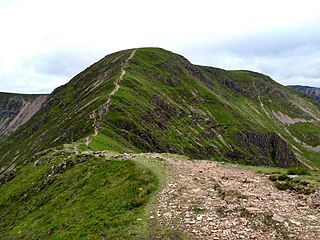
Robinson is a fell in the English Lake District, its southern slopes descending to Buttermere, while its northern side is set in the Newlands Valley. Paths lead to the summit from the village of Buttermere, from the nearby summit Dale Head and from various locations in the valleys to the north.

<span class="mw-page-title-main">Grasmoor</span> Mountain in the English Lake District, Cumbria, England

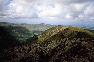
Grasmoor is a mountain in the north-western part of the Lake District, northern England. It is the highest peak in a group of hills between the villages of Lorton, Braithwaite and Buttermere, and overlooks Crummock Water.

<span class="mw-page-title-main">Buckbarrow</span>

Buckbarrow is a small fell in the English Lake District overlooking the western end of Wastwater. It is featured in Alfred Wainwright’s Pictorial Guide to the Lakeland Fells and is given a height of 1,410 ft approximately; however, the Ordnance Survey and other guidebooks now give an altitude of 423 m (1,388 ft). The fell’s name means ‘The hill of the buck or goat’. It is derived either from the Old English word bucc meaning buck or the Old Norse word bokki meaning a male goat.

<span class="mw-page-title-main">Dollywaggon Pike</span> Mountain in the English Lake District, Cumbria, England

Dollywaggon Pike is a fell in the English Lake District. It stands on the main spine of the Helvellyn range in the Eastern Fells, between Thirlmere and the Ullswater catchment.

<span class="mw-page-title-main">Crag Hill</span>

Crag Hill is a mountain in the North Western part of the English Lake District. It was formerly known as Eel Crag; however, the Ordnance Survey now marks Eel Crag as referring to the northern crags of the fell. It is not to be confused with another Crag Hill lying on the border of North Yorkshire.

<span class="mw-page-title-main">Causey Pike</span> Mountain in the English Lake District, Cumbria, England

Causey Pike is a fell in the English Lake District. It is situated in the Newlands Valley, 5 km south-west of the town of Keswick. Even though it has a modest height of 637 metres (2,090 ft) it is one of the most distinctive fells when viewed from the Derwent Water and Keswick area due to its distinguishing summit "knobble" which catches the eye. The fell is one of 214 fells described by Alfred Wainwright in his series of Pictorial Guides to the Lakeland Fells: Causey Pike features in Book Six, The North Western Fells.

<span class="mw-page-title-main">Blake Fell</span>

Blake Fell is a hill in the Western part of the English Lake District. It is the highest point of the Loweswater Fells, an area of low grassy hills with steep sides overlooking the lake of Loweswater. The fell also overlooks the village of Loweswater, from which it can be climbed. An alternative route is from the Cogra Moss reservoir on its western slopes. Because the Loweswater Fells are a separate geographical unit, Blake Fell is a Marilyn. It is located in the Parish of Lamplugh.

<span class="mw-page-title-main">Outerside</span> Fell in the Lake District, Cumbria, England

Outerside is a fell in the Lake District in Cumbria, England. It is located 6 kilometres west of Keswick in the north western part of the national park and is a smaller member of the Coledale group of fells with a height of 568 metres (1863 feet). The fell is part of a ridge on the southern side of Coledale which descends from the higher fell of Scar Crags and continues over the neighbouring smaller fell of Barrow before reaching the valley at the village of Braithwaite.

<span class="mw-page-title-main">Whiteside (Lake District)</span>

Whiteside is a fell in the north-western area of the English Lake District. It stands at the western end of the Grisedale Pike- Hopegill Head ridge overlooking Crummock Water.

<span class="mw-page-title-main">Wandope</span> Fell in the Lake District, Cumbria, England

Wandope is a fell in the north-western area of the English Lake District. It lies to the east of Crummock Water and south of Crag Hill. From the summit there are excellent panoramas of the Sca Fell and High Stile ranges.

<span class="mw-page-title-main">Whiteless Pike</span> Fell in England

Whiteless Pike is a fell in the north-western English Lake District. It stands immediately east of Crummock Water and forms a pyramid shape when viewed from Rannerdale. In his celebrated guide to the Lakeland fells, Alfred Wainwright called it "the Weisshorn of Buttermere". There are good views of Great Gable and the Scafells from the summit.

<span class="mw-page-title-main">Green Gable</span> Mountain in the Lake District, England

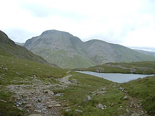
Green Gable is a fell in the English Lake District often traversed by walkers en route to its more famous neighbour Great Gable. It can be ascended from Honister Pass, Seathwaite in Borrowdale, or Ennerdale. There are good views of Gable Crag, Scafell Pike and the Buttermere valley from the summit.

<span class="mw-page-title-main">Sail (Lake District)</span>

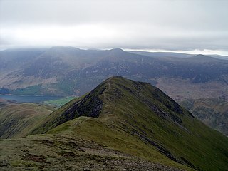
Sail is a hill in the English Lake District, lying between Derwentwater and Crummock Water.

<span class="mw-page-title-main">Sale Fell</span> Mountain in United Kingdom

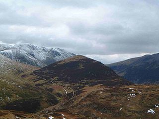
Sale Fell is a small hill near Cockermouth in the English Lake District. It is popular with locals, as it offers gentle walking and lovely views across Bassenthwaite Lake to Skiddaw.

<span class="mw-page-title-main">Broom Fell</span>

Broom Fell is a small hill in the English Lake District. It lies on a ridge connecting Lord's Seat and Graystones, but is rarely climbed. Alfred Wainwright did however accord it the status of a separate fell in his influential guidebook series, the Pictorial Guide to the Lakeland Fells.

<span class="mw-page-title-main">Ling Fell</span> Hill in Britain

Ling Fell is a small hill in the north west of the Lake District in the United Kingdom. It is close to the village of Wythop Mill, from where it can easily be climbed. The fell is shaped like a wide dome, with no particular dangers. Its name derives from the fact that it is largely covered in heather, also known as "ling". The summit has good views of the town of Cockermouth.

<span class="mw-page-title-main">Graystones</span>

Graystones is a fell in the English Lake District. It lies in the North Western Fells region and is one of the peaks on the ridge which encircles the valley of Aiken Beck.

<span class="mw-page-title-main">Lord's Seat</span> Hill in United Kingdom

Lord's Seat is a fell in the English Lake District. It is the highest of the group of hills north of Whinlatter Pass in the North Western Fells. The slopes of Lord's Seat are extensively forested.

<span class="mw-page-title-main">North Western Fells</span>

The North Western Fells are a group of hills in the English Lake District. Including such favourites as Catbells and Grisedale Pike, they occupy an oval area beneath the Buttermere and Borrowdale valley systems. The North Western Fells are characterised by soaring east-west ridges and an absence of mountain tarns.

References

  1. Place Names of the Lake District. Gives origins and translation of name.
  2. 1 2 3 4 Alfred Wainwright: A Pictorial Guide to the Lakeland Fells, Book 6, The North Western Fells: Westmorland Gazette (1964): ISBN   0-7112-2459-5
  3. 1 2 3 Bill Birkett: Complete Lakeland Fells: Collins Willow (1994): ISBN   0-00-713629-3
  4. British Geological Survey: 1:50,000 series maps, England & Wales Sheet 29: BGS (1999)