
Fishtown is a neighborhood in the River Wards section of Philadelphia, Pennsylvania, United States. Located northeast of Center City Philadelphia, its borders are somewhat disputed today due to many factors, but are roughly defined by the triangle created by the Delaware River, Front Street, and York Street. Some newer residents expand the area to Lehigh Avenue to the northeast, while some older residents shrink the area to Norris Street. It is served by the Market–Frankford Line rapid transit subway/elevated line of the SEPTA system. Fishtown is a largely working class Irish Catholic neighborhood, but has recently seen a large influx of young urban professionals and gentrification.
Frankford is a neighborhood in the Northeast section of Philadelphia situated about six miles (10 km) northeast of Center City. Although its borders are vaguely defined, the neighborhood is bounded roughly by the original course of Frankford Creek on the south to Castor Avenue on the northwest and southwest, to Cheltenham Avenue on the north, and to Aramingo Avenue and I-95 on the east. [source: GoogleMaps] Adjacent neighborhoods are Bridesburg, Juniata, Northwood, Summerdale, and Wissinoming.
Holmesburg began as a Village within Lower Dublin Township, Pennsylvania. It is now a neighborhood in the Northeast section of Philadelphia, Pennsylvania, United States. Holmesburg was named in Honor of Surveyor General of Pennsylvania Thomas Holme, who was a cartographer.

Torresdale, also formerly known as Torrisdale, is a neighborhood in the Far Northeast section of Philadelphia, Pennsylvania, United States. Torresdale is located along the Delaware River between Holmesburg and Bensalem Township in neighboring Bucks County.
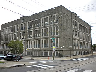
Frankford High School is a public high school in the School District of Philadelphia. It is located at Oxford Avenue and Wakeling Street in the Frankford section of Northeast Philadelphia, Pennsylvania. It has an award-winning and highly successful Culinary Arts Program.

The Frankford Avenue Bridge, also known as the Pennypack Creek Bridge, the Pennypack Bridge, the Holmesburg Bridge, and the King's Highway Bridge, erected in 1697 in the Holmesburg section of Northeast Philadelphia, in the U.S. state of Pennsylvania, is the oldest surviving roadway bridge in the United States. The three-span, 73-foot-long (22 m) twin stone arch bridge carries Frankford Avenue, just north of Solly Avenue, over Pennypack Creek in Pennypack Park.
Oxford Circle is a neighborhood in the lower Northeast section of Philadelphia, Pennsylvania, United States. Its namesake is the much used traffic circle at Roosevelt Boulevard and Oxford Avenue. The Oxford Circle neighborhood has traditionally included the areas up to Rhawnhurst and Mayfair but does not really have a fixed boundary, other than in publications about Philadelphia which are of a public relations or informational nature.
Lloyd Titus was an American architect who designed at least 10 school buildings that are listed on the U.S. National Register of Historic Places (NRHP).
The William Henry Harrison School building, now known as St. Malachy Catholic School, is an historic American structure that is located at 1012 West Thompson Street in the Yorktown neighborhood of Philadelphia, Pennsylvania.

The John Marshall Elementary School is an historic elementary school that is located in the Frankford neighborhood of Philadelphia, Pennsylvania. It is part of the School District of Philadelphia.

The Henry Longfellow School was an historic school building which was located in the Bridesburg neighborhood of Philadelphia, Pennsylvania.

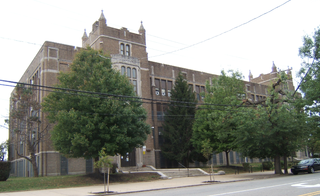
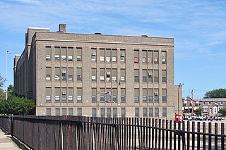
The Warren G. Harding Middle School is an historic, American middle school that is located in the Frankford neighborhood of Philadelphia, Pennsylvania. It is part of the School District of Philadelphia.
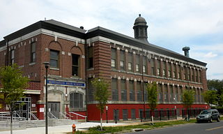
The James J. Sullivan School is a historic elementary school that is located in the Frankford neighborhood of Philadelphia, Pennsylvania, United States.

The Mastery Charter School - Smedley Elementary is an American charter school that is located in the Frankford neighborhood of Philadelphia, Pennsylvania.
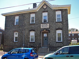
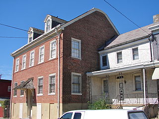
The David Wilmot Public School For Coloured Children, also known as the J.C. King Educational Building, is located the Frankford neighborhood of Philadelphia, Pennsylvania. Built in 1874, it is a two-story, four bay, stone building in the Italianate-design presumably of Lewis H. Esler (1819-1883), a prominent architect employed by the Philadelphia Board of Public Education.

Charles Schaeffer School is a historic former school building located in the Germantown neighborhood of Philadelphia, Pennsylvania. The building was renovated in 2019 and is now the corporate offices of the Philly Office Retail real estate company.

Germantown Grammar School, also known as Lafayette Grammar School and Opportunities Industrial Center, Inc., are two historic school buildings located in the Germantown neighborhood of Philadelphia, Pennsylvania.
The Thomas Buchanan Read School is an historic, American school building that is located in the Elmwood Park neighborhood of Philadelphia, Pennsylvania.

Parkway West High School is an American public magnet high school that is located in the Mill Creek neighborhood of Philadelphia, Pennsylvania. It shares a site with the Middle Years Alternative School for the Humanities (MYA). Both schools are part of the School District of Philadelphia.

Girard Avenue is a major commercial and residential street in Philadelphia, Pennsylvania. For most of its length it runs east–west, but at Frankford Avenue it makes a 135-degree turn north. Parts of the road are signed as U.S. Route 13 and U.S. Route 30.


