Related Research Articles


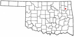
Rogers County is located in the northeastern part of the U.S. state of Oklahoma. As of the 2020 census, the population was 95,240, making it the sixth-most populous county in Oklahoma. The county seat is Claremore. Rogers County is included in the Tulsa, OK metropolitan statistical area.
Nowata County is a county located in northeastern Oklahoma, United States, on the Kansas border. As of the 2020 census, its population is 9,320. Its county seat is Nowata. Their name is derived from a Delaware word, no-we-ata, meaning "come here" or "welcome".

Mayes County is a county located in the U.S. state of Oklahoma. As of the 2020 census, the population was 39,046. Its county seat is Pryor Creek. Named for Samuel Houston Mayes, Principal Chief of the Cherokee Nation from 1895 to 1899, it was originally created at the Sequoyah Convention in August 1905.

Gage is a town in Ellis County, Oklahoma, United States. The population was 433 at the time of the 2020 census.
Hoot Owl is a town in Mayes County, Oklahoma, As of the 2020 census, the population was 0, down from 4 in 2010, which makes it the smallest incorporated town in the state of Oklahoma.
Pryor Creek or Pryor is a city in and county seat of Mayes County, Oklahoma, United States. The population was 8,659 at the 2000 census and 9,539 in the 2010 census.

New Alluwe is a town in Nowata County, Oklahoma, United States. The population was 95 at the 2000 census.

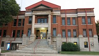
Claremore is a city and the county seat of Rogers County in Green Country or northeastern Oklahoma, United States. The population was 19,580 at the 2020 census, a 5.4 percent increase over the figure of 18,581 recorded in 2010. Located in the foothills of the Ozark Mountains. It is home of Rogers State University.

Oologah is a town in Rogers County, Oklahoma, United States. Renowned humorist Will Rogers was born on a ranch two miles east of Oologah, although he usually claimed Claremore as his birthplace "because nobody but an Indian can pronounce 'Oologah.'" There has been disagreement about the proper spelling for the town name. The official spelling is now Oologah. It was often spelled Oolagah before statehood, and this spelling appears on some old buildings.

The Ausable River, also known as AuSable River and originally written as "Au Sable", runs in the U.S. state of New York, from the Adirondack Mountains and past the village of Lake Placid and Au Sable Forks to empty into Lake Champlain. It has an East and West branch that join at Au Sable Forks. The river forms a partial boundary between Clinton County and Essex County. The Ausable River is known for its gorge, Ausable Chasm, located a few miles east of Keeseville.
A concrete mixer is a device that homogeneously combines cement, aggregate, and water to form concrete. A typical concrete mixer uses a revolving drum to mix the components. For smaller volume works, portable concrete mixers are often used so that the concrete can be made at the construction site, giving the workers ample time to use the concrete before it hardens. An alternative to a machine is mixing concrete by hand. This is usually done in a wheelbarrow; however, several companies have recently begun to sell modified tarps for this purpose.

Green Country, sometimes referred to as Northeast Oklahoma, is the northeastern portion of the U.S. state of Oklahoma, which lies west of the northern half of Arkansas, the southwestern corner the way of Missouri, and south of Kansas.

The Verdigris River is a tributary of the Arkansas River in southeastern Kansas and northeastern Oklahoma in the United States. It is about 310 miles (500 km) long. Via the Arkansas, it is part of the Mississippi River watershed.
KRSU-TV is an educational independent television station in Claremore, Oklahoma, United States, serving the Tulsa area. Owned by Rogers State University, the station maintains studios on the university's campus on West Will Rogers Boulevard in Claremore, and its transmitter is located to the adjacent southeast of Oologah Lake in northern Rogers County.

The Tulsa metropolitan area, officially defined as the Tulsa metropolitan statistical area is a metropolis in northeastern Oklahoma centered around the city of Tulsa and encompassing Tulsa, Rogers, Wagoner, Osage, Creek, Okmulgee and Pawnee counties. It had a population of 1,034,123 according to the 2022 U.S. census estimates.

State Highway 88, abbreviated to SH-88 or OK-88, is a state highway in Oklahoma. It runs for 26.0 miles (42 km) north–south through Rogers County. It has no lettered spur routes.

Lake Oologah is a reservoir in northeastern Oklahoma. It is located near the towns of Oologah, Nowata, and Claremore. The lake has a surface of 29,500 acres (119 km2) of water and 209 miles (336 km) of shoreline with 11 lake-side parks. The water storage capacity is rated as 552,210 acre-feet (681,140,000 m3). The lake is formed along the Verdigris River, and is a source of water for the Tulsa Metropolitan Area. The purpose of the dam and lake is flood control, water supply, navigation, recreation, and fish and wildlife.

U.S. Route 169 is a U.S. highway that begins in Tulsa southeast of Downtown. The highway runs north into Kansas.
Alluwe is a ghost town in Nowata County, Oklahoma. The post office was established as Lightening Creek on October 23, 1872, after the namesake waterway. On June 27, 1883, the town was renamed Alluwe. The post office existed under this new name until July 31, 1909.
References
- ↑ U.S. Geological Survey Geographic Names Information System: Winganon, Oklahoma
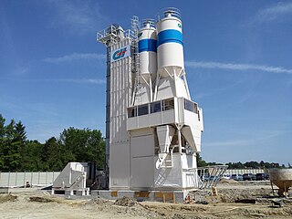
- ↑ "Lost Cement Mixer Of Winganon Gets Space-Age Update". News On 6. KOTV-DT. October 27, 2015. Retrieved November 28, 2018.
Municipalities and communities of Rogers County, Oklahoma, United States | ||
|---|---|---|
| Cities |  | |
| Towns | ||
| CDPs | ||
| Other communities | ||
| Indian reservations | ||
| Footnotes | ‡This populated place also has portions in an adjacent county or counties | |