Witham on the Hill

Last updated

Witham on the Hill
Church of St Andrew, Witham on the Hill - geograph.org.uk - 203015.jpg
St Andrew, Witham on the Hill
Lincolnshire UK location map.svg
Red pog.svg
Witham on the Hill
Location within Lincolnshire
Population260 (2011 census)
OS grid reference TF053165
  London 85 mi (137 km)  SSE
Civil parish
  • Witham on the Hill
District
Shire county
Region
Country England
Sovereign state United Kingdom
Post town BOURNE
Postcode district PE10
Dialling code 01778
Police Lincolnshire
Fire Lincolnshire
Ambulance East Midlands
UK Parliament
List of places
UK
England
Lincolnshire
52°44′10″N0°26′28″W / 52.73616°N 0.44102°W / 52.73616; -0.44102

Witham on the Hill is a village and civil parish in the South Kesteven district of Lincolnshire, England. [1] The population of the civil parish was 260 at the 2011 census. [2]

Contents

History

Witham-on-the-Hill stocks Witham-on-the-Hill stocks - geograph.org.uk - 298968.jpg
Witham-on-the-Hill stocks

The hall is a Grade II listed building, dating from ca 1730 but extended several times. [3] The hall was once owned by descendants of Archdeacon Robert Johnson, the founder of Oakham and Uppingham Schools, including Lieutenant-General William Augustus Johnson MP. [4]

The parish church is dedicated to Saint Andrew. The tower and steeple were re-built in a medieval revival style by the Stamford architect George Portwood in 1737–8. [5] [6]

The original village stocks and whipping post are preserved under a modern canopy. [7]

In 2002, West Farm (on the Little Bytham road) had trials for GM rapeseed planted by Aventis. [8] [9]

Geography

The village is between the east and west tributaries of the River Glen, and despite its name, is not on the top of its 'hill', which reaches a peak 1 mile (1.6 km) west towards Careby. It is approximately 0.5 miles (0.8 km) from the A6121 Bourne-Stamford road. To the west is Little Bytham, and to the east are Manthorpe and Toft. The predominant landowner in the area is the Grimsthorpe Estate.

The civil parish covers a large area, extending north into Grimsthorpe Park and Dobbins Wood where it meets the boundary of Edenham, and the boundary with Toft with Lound and Manthorpe is mostly along the A6121. Manthorpe, Bourne used to be part of the civil parish.

Community

Witham Hall Witham Hall near Bourne, Lincolnshire (geograph 4293091).jpg
Witham Hall

The village has a co-educational preparatory school, Witham Hall, which marked its 50th year in 2009. The nearest state primary school is on Creeton Road in Little Bytham. Secondary schools are in Bourne.

The Six Bells public house was built in 1905 by the architect A. N. Prentice and is Grade II listed. [10] It is on the road to the A6121. When built, the parish church did have six bells, but in 1932 they were augmented to eight.

Related Research Articles

<span class="mw-page-title-main">Bourne, Lincolnshire</span> Market town in Lincolnshire, England

Bourne is a market town and civil parish in the South Kesteven district of Lincolnshire, England. It lies on the eastern slopes of the limestone Kesteven Uplands and the western edge of the Fens, 11 miles (18 km) north-east of Stamford, 12 miles (19 km) west of Spalding and 17 miles (27 km) north of Peterborough. The population at the 2011 census was 14,456. A 2019 estimate put it at 16,780.

<span class="mw-page-title-main">South Kesteven</span> Local government district in Lincolnshire, England

South Kesteven is a local government district in Lincolnshire, England, forming part of the traditional Kesteven division of the county. Its council is based in Grantham. The district also includes the towns of Bourne, Market Deeping and Stamford, along with numerous villages and surrounding rural areas.

<span class="mw-page-title-main">Thurlby, South Kesteven</span> Village and civil parish in the South Kesteven district of Lincolnshire, England

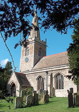
Thurlby is a village and civil parish in the South Kesteven district of Lincolnshire, England. It is situated just west of the A15 road, 2 miles (3 km) south from the town of Bourne, and on the edge of the Lincolnshire Fens. It is sometimes referred to as Thurlby by Bourne to distinguish it from other villages in Lincolnshire with the same name. Thurlby and the hamlet of Northorpe to its north are conjoined. The parish had a population of 2,136 at the 2001 census and 2,153 at the 2011 census.

<span class="mw-page-title-main">Aslackby and Laughton</span> Civil parish in the South Kesteven district of Lincolnshire, England

Aslackby and Laughton is a civil parish in the South Kesteven district of Lincolnshire, England. According to the 2001 census the parish had a population of 243, in 102 households. increasing slightly to 251 in 118 households at the 2011 census. It consists of the village of Aslackby, the hamlet of Laughton, and scattered farms, and part of the hamlet of Graby.

<span class="mw-page-title-main">Braceborough</span> Village in the South Kesteven district of Lincolnshire, England

Braceborough is a village in the civil parish of Braceborough and Wilsthorpe, in the South Kesteven district of Lincolnshire, England. It is situated off the Stamford to Bourne A6121 road, just west of the A15 as it runs between Market Deeping and Bourne. In 1921 the parish had a population of 150. On 1 April 1931 the parish was abolished and merged with Wilsthorpe to form "Braceborough and Wilsthorpe".

<span class="mw-page-title-main">Castle Bytham</span> Village and civil parish of around 300 houses in South Kesteven, Lincolnshire, England

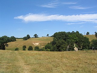
Castle Bytham is a village and civil parish of around 300 houses in South Kesteven, Lincolnshire, England. It is located 9 miles (14 km) north of Stamford and 9 miles (14 km) west of Bourne.The population was measured at 768 in 317 households at the 2011 census.

<span class="mw-page-title-main">Edenham</span> Village and civil parish in the South Kesteven district of Lincolnshire, England

Edenham is a village and civil parish in the South Kesteven district of Lincolnshire, England. It is approximately 3 miles (5 km) north-west of Bourne, and on the A151 road. While the civil parish is called 'Edenham', the parish council is called Edenham, Grimsthorpe, Elsthorpe & Scottlethorpe Parish Council. The population of the civil parish at the 2011 census was 291.

North Witham is a small village and nominally a civil parish in South Kesteven, Lincolnshire, England. The village is located along the upper course of the River Witham 1.5 miles downstream (north) of South Witham, and approximately 9 miles (14 km) south from the nearest major town, Grantham. It has an estimated population of 143 in around 72 households, at a density of 0.1/hectare.

<span class="mw-page-title-main">Little Bytham</span> Village and civil parish in the South Kesteven district of Lincolnshire, England

Little Bytham is a village and civil parish in the South Kesteven district of Lincolnshire, England. The population of the civil parish at the 2011 census was 384. It lies on the B1176 road, 4 miles (6 km) south from Corby Glen and 6 miles (10 km) north from Stamford.

<span class="mw-page-title-main">Aunby</span> Village in Lincolnshire, England

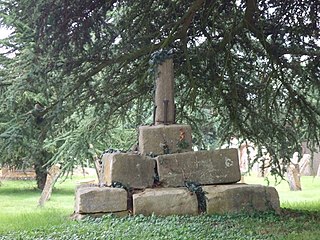
Aunby is a village in the civil parish of Careby Aunby and Holywell, in the South Kesteven district of Lincolnshire, England. It is situated north from Stamford on the B1176 road, and just south of Careby. In 1921 the parish had a population of 42. Aunby was formerly in the parish of Castle Bytham, in 1866 Aunby became a separate civil parish, on 1 April 1931 the parish was abolished to form "Careby, Aunby and Holywell".

<span class="mw-page-title-main">Swayfield</span> Village and civil parish in the South Kesteven district of Lincolnshire, England

Swayfield is a village and civil parish in the South Kesteven district of Lincolnshire, England. The population of the civil parish at the 2011 census was 316. It is situated just over 3 miles (5 km) east from the A1 road, 9 miles (14 km) south-east from Grantham and 10 miles (16 km) north from Stamford. It has approximately 138 houses.

<span class="mw-page-title-main">A6121 road</span> Road in England

The A6121 is a short cross-country road in the counties of Lincolnshire and Rutland, England. It forms the principal route between Bourne and Stamford and the A1 in Lincolnshire, continuing on through Ketton in Rutland to its junction with the A47 at Morcott. Its south-western end is at 52°35.5860′N0°38.0820′W and its north-eastern end is at 52°45.9120′N0°24.0660′W. The road has increased in importance with the rapid expansion of housing in this part of South Kesteven.

<span class="mw-page-title-main">Toft, Lincolnshire</span> Small village in the South Kesteven district of Lincolnshire, England

Toft is a small village in the South Kesteven district of Lincolnshire, England. It is situated approximately 2 miles (3 km) south-west from Bourne on the A6121. Toft is part of the civil parish of Toft with Lound and Manthorpe. The population of the civil parish at the 2011 census was 333.

<span class="mw-page-title-main">Swinstead</span> Village and civil parish in the South Kesteven district of Lincolnshire, England

Swinstead is a village and civil parish in the South Kesteven district of Lincolnshire, England. It is situated 5 miles (8.0 km) west from Bourne, 9 miles (14.5 km) north from Stamford and 11 miles (17.7 km) south-east from Grantham. It is a village of just over 100 households, the population of the civil parish being measured at 234 in the 2011 census.

<span class="mw-page-title-main">Careby Aunby and Holywell</span> Civil parish in South Kesteven, England

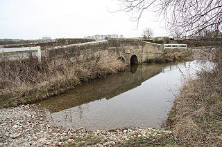
Careby Aunby and Holywell is a civil parish in the district of South Kesteven, south-west Lincolnshire, in England. It stretches from the county border with Rutland in the west to the River West Glen in the east. The B1176 road from Corby Glen passes through Careby and on past Aunby toward Stamford. The main London to Scotland railway line passes through the parish, the line upon which Mallard took the speed record for the LNER.

<span class="mw-page-title-main">Manthorpe, Grantham</span> Village in South Kesteven district, Lincolnshire, England

Manthorpe is a village in the South Kesteven district of Lincolnshire, England. It is on the northern edge of the town of Grantham and on the Grantham to Lincoln A607 road, between the East Coast Main Line and the River Witham. The village is part of the civil parish of Belton and Manthorpe.

<span class="mw-page-title-main">Manthorpe, Bourne</span> Small village in the South Kesteven district of Lincolnshire, England

Manthorpe is a small village in the South Kesteven district of Lincolnshire, England. It lies 0.5 miles (0.8 km) east from the A6121, 3 miles (5 km) south-west from Bourne and 6 miles (10 km) north-east from Stamford.

<span class="mw-page-title-main">Lound, Lincolnshire</span> Village in the South Kesteven district of Lincolnshire, England

Lound is a village in the South Kesteven district of Lincolnshire, England. It is situated about 2 miles (3 km) south-west from the town of Bourne.

References

  1. "Witham on the Hill". Parishes in Lincolnshire. Lincolnshire county council. Retrieved 17 August 2013.
  2. "Civil Parish population 2011". Neighbourhood Statistics. Office for National Statistics. Retrieved 4 June 2016.
  3. Historic England. "Witham Hall and three archways (Grade II) (1240121)". National Heritage List for England . Retrieved 12 June 2017.
  4. Needle, Rex. "Village history".
  5. Historic England. "the church (348189)". Research records (formerly PastScape). Retrieved 12 September 2009.
  6. "Archived copy" (PDF). Archived from the original (PDF) on 22 May 2017. Retrieved 20 November 2017.{{cite web}}: CS1 maint: archived copy as title (link)
  7. Historic England. "National monument record for stocks (348192)". Research records (formerly PastScape). Retrieved 12 September 2009.
  8. "GM weeds finally destroyed". Archived press release. Friends of The Earth. 7 December 2001.
  9. Lean, Geoffrey (28 October 2007). "GM: The Secret Files". The Independent. The spectre of GM contamination has cost John Turner dear. A succession of trials near his 250 acre farm in Little Bytham, south Lincolnshire, between 2000 and 2002 forced him to stop growing certain crops – suffering heavy financial losses as a result.
  10. Historic England. "The Six Bells Public House (1240120)". National Heritage List for England . Retrieved 3 May 2020.