Nassau is the capital and largest city of The Bahamas. With a population of 274,400 as of 2016, or just over 70% of the entire population of the Bahamas (≈391,000), Nassau is commonly defined as a primate city, dwarfing all other towns in the country. It is the centre of commerce, education, law, administration and media of the country.
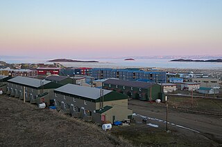
Frobisher Bay is an inlet of the Davis Strait in the Qikiqtaaluk Region of Nunavut, Canada. It is located in the southeastern corner of Baffin Island. Its length is about 230 km (140 mi) and its width varies from about 40 km (25 mi) at its outlet into the Labrador Sea to roughly 20 km (12 mi) towards its inner end.

Georgian Bay is a large bay of Lake Huron, in the Laurentia bioregion. It is located entirely within the borders of Ontario, Canada. The main body of the bay lies east of the Bruce Peninsula and Manitoulin Island. To its northwest is the North Channel.

Bruny Island is a 362-square-kilometre (89,000-acre) island located off the south-eastern coast of Tasmania, Australia. The island is separated from the Tasmanian mainland by the D'Entrecasteaux Channel, and its east coast lies within the Tasman Sea. Storm Bay is located to the island's northeast. Both the island and the channel are named after French explorer Bruni d'Entrecasteaux. Its traditional Aboriginal name is lunawanna-allonah, which survives as the name of two island settlements, Alonnah and Lunawanna.

Charlton Island (Sivukutaitiarruvik) is an uninhabited island located in James Bay, Qikiqtaaluk Region, Nunavut, Canada. Located northwest of Rupert Bay, it has an area of 308 km2 (119 sq mi).

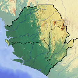
The Banana Islands are a group of islands that lie off the coast of Yawri Bay, south west of the Freetown Peninsula in the Western Area of Sierra Leone.

Don Edwards San Francisco Bay National Wildlife Refuge (DESFBNWR) is a United States National Wildlife Refuge located in the southern part of San Francisco Bay, California. The Refuge headquarters and visitor center is located in the Baylands district of Fremont, next to Coyote Hills Regional Park, in Alameda County. The visitor center is on Marshlands Rd, off Thornton Ave.
Rock Bay Marine Provincial Park is a provincial park in British Columbia, Canada, located on the Inside Passage at the junction of Johnstone Strait and Discovery Passage. The park contains approximately 525 ha. Rock Bay is located on the shore of Vancouver Island, immediately south of East Thurlow Island.

Padilla Bay is a bay located in the U.S. state of Washington, between the San Juan Islands and the mainland. Fidalgo Island and Guemes Island lie to the west of Padilla Bay. Guemes Channel, between the islands, connects Padilla Bay to Rosario Strait. Samish Island lies to the north of Padilla Bay, beyond which is Samish Bay and Bellingham Bay.

Mount Hope Bay is a tidal estuary located at the mouth of the Taunton River on the Massachusetts and Rhode Island border. It is an arm of Narragansett Bay. The bay is named after Mount Hope, a small hill located on its western shore in what is now Bristol, Rhode Island. It flows into the East Passage of Narragansett Bay and also the Sakonnet River. Mount Hope Bay has played an important role to the history of the area, from pre-colonial times to the present. While many years of sewage and industrial pollution have severely degraded the quality of the shallow waters of the bay, there are currently major efforts underway to clean up and restore it.

The Pamparomas District is one of 10 districts of the Huaylas Province in the Ancash Region of Peru. The capital of the district is the village of Pamparomas. The district was founded on January 2, 1857.
Yanaoca District is one of eight districts in the Canas Province in Peru. Its seat is Yanaoca.
Seniora Doll, or Senora Doll, was a Sherbro princess. She held the position of the duchess of the Ya Kumba ruling house of the Yawri Bay Area between the Sierra Leone peninsula and the Sherbro estuary. In the late 17th century, she married an English trader and Royal African Company agent, Thomas Corker, and their two sons Stephen and Robin ruled as the first Caulker chiefs through her royal lineage. She died in 1722, twenty two years after Thomas Corker died in 1700 in England.
Quiñota District is one of eight districts of the Chumbivilcas Province in Peru.

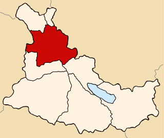
Espinar District is one of eight districts of the Espinar Province in Peru. Its seat is Yauri (Yawri).

Indian Lake is a 12-mile (19 km) long, 4,255-acre (1,722 ha) reservoir with a southwest to northeast orientation in the towns of Indian Lake and Lake Pleasant in Hamilton County, in the Adirondack Park of New York State, in the United States. The hamlet of Indian Lake is located 2 miles (3.2 km) north of the north end of Indian Lake. New York State Route 30 runs along the west shore of the lake. Most of the shore is part of the Forest Preserve. Indian Lake is fed by the Jessup River, and drains through the Indian River into Lake Abanakee, and from there through the Indian River to the Hudson River.

Mount Dutton Bay Conservation Park is a protected area in the Australian state of South Australia located on the west coast of Eyre Peninsula on islands located on waters in the sector between the north west to the east of the town of Coffin Bay.

Lampung Bay is a large bay located on the southern tip of Sumatra Island in the Sunda Strait waters. At the southern tip of Sumatra there are two large bays, Semangka Bay is located in the Eastern part.