The Ta'an Kwach'an Council or Ta'an Kwäch’än Council is a self-governing Indigenous government whose traditional territory is located around the Whitehorse and Lake Laberge area in Canada's Yukon Territory. It split from the Kwanlin Dün First Nation to negotiate a separate land claim. The language originally spoken by the Ta’an Kwäch’än was Southern Tutchone. The Ta’an Kwäch’än comprise people of Southern Tutchone, Tagish and Tlingit descent. Approximately 50 per cent of the Ta’an Kwäch’än citizens now live in Whitehorse, Yukon Territory, with the balance disbursed throughout the rest of Canada, in the United States of America, and abroad. The Ta'an Kwäch’än take their name from Tàa'an Män in the heart of their traditional territory - so they called themselves ″People from Lake Laberge″.
The Teslin Tlingit Council (TTC) is a First Nation band government in the central Yukon in Canada, located in Teslin, Yukon along the Alaska Highway and Teslin Lake. The language originally spoken by the Teslin Tlingit or Deisleen Ḵwáan is Tlingit. Together with the Taku River Tlingit or Áa Tlein Ḵwáan around Atlin Lake of the Taku River Tlingit First Nation in British Columbia, and carcross tagish first nation or natasaaheeni, they comprise the Inland Tlingit.
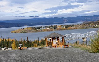
The community of Teslin(/'tɛs.lɪn/ TESS-lin) includes the Village of Teslin in Yukon, Canada. Teslin is situated at historical Mile 804 on the Alaska Highway along Teslin Lake. The Hudson's Bay Company established a small trading post at Teslin in 1903.

The Teslin River is a river in southern Yukon Territory and northwestern British Columbia, Canada, that flows 632 kilometres (393 mi) from its source south of Teslin Lake to its confluence with the Yukon River.
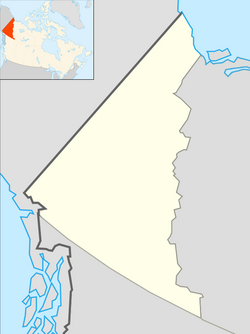
Pelly-Nisutlin is an electoral district which returns a member to the Legislative Assembly of the Yukon Territory in Canada. It was created in 2002 out of the districts of Faro and Ross River-Southern Lakes. The riding includes the communities of Teslin, Faro, Ross River, Little Salmon, and Johnsons Crossing. It encompasses the traditional territory of the Teslin Tlingit Council and the Ross River Dena Council of the Kaska Dena. Pelly-Nisutlin is bordered by the rural ridings of Mayo-Tatchun, Lake Laberge, Mount Lorne-Southern Lakes, and Watson Lake.
The Tuya Range is a mountain range in the Stikine Ranges of the Cassiar Mountains in the far north of the Canadian province of British Columbia, near its border with the Yukon Territory and to the southwest of Watson Lake, Yukon, which is the nearest major settlement.
The Atsutla Range is a granitic mountain range on the Kawdy Plateau in northern British Columbia, Canada. The Atsutla Range lies south of the Yukon border in between Teslin Lake and the Stewart-Cassiar Highway, roughly 120 km (75 mi) north-northeast of Dease Lake.
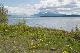
Teslin Lake is a large lake spanning the border between British Columbia and Yukon, Canada. It is one of a group of large lakes in the region of far northwestern BC, east of the upper Alaska Panhandle, which are the southern extremity of the basin of the Yukon River, and which are known in Yukon as "the Southern Lakes". The lake is fed and drained primarily by the Teslin River, south and north, but is also fed from the east by the Jennings River and the Swift River, and from the west by the Hayes River.
The Nisutlin Plateau is a sub-plateau, of the Yukon Plateau physiographic section, in northern British Columbia, Canada, extending east from Teslin Lake to the Cassiar Mountains.
The Swift River is a river that begins in Yukon Territory and flows southwest into British Columbia to its mouth at the east side of Teslin Lake on the Teslin River system. The river drains the uppermost portion of the Cassiar Mountains and in its lower reaches traverses the Nisutlin Plateau, which lies along the east side of Teslin Lake north of the mouth of the Jennings River, which is to the south of the Swift.
The Jennings River is a river in far northern British Columbia, Canada. It is approximately 150 kilometres (93 mi) long. The river was named for William T. Jennings (1846-1906), a civil engineer who, in 1897, assessed various road and railroad routes from the Pacific Ocean to the Yukon.

The Teslin Plateau is a sub-plateau, of the Yukon Plateau physiographic section, in northern British Columbia, Canada, located north of the Nakina River between Atlin Lake and Teslin Lake.
The Dän Tàgé is a river in Yukon Territory, Canada. It is in the Yukon River drainage basin, begins at the uppermost of the Loon Lakes, and is a right tributary of the Teslin River.
The Taku Plateau is a sub-plateau of the Stikine Plateau in the far northwestern Interior of British Columbia, Canada. It lies to the south of the Teslin Plateau, part of the Yukon Plateau and to the southeast of the Yukon Plateau's other major sub-area within British Columbia, the Tagish Highland. Immediately northeast is the Kawdy Plateau and to the northwest of the Nahlin Plateau. The Inklin River forms the plateau's southwestern boundary with the northwestern extremities of the Tahltan Highland, beyond which are the Boundary Ranges. Very mountainous, its highest summit is Nahlin Mountain.
Quiet Lake is a lake in Yukon, Canada that is 28 kilometres (17 mi) in length and at 5,391.3 hectares the largest lake of the three Big Salmon River system lakes. It was named in 1887 by John McCormack, a gold prospector. Prior to the construction of the South Canol road, which was completed in the 1940s, the area was mostly reached by boating hundreds of miles up the Big Salmon, Teslin or Nisutlin rivers.
Teslin is the anglicized form of the name of the Deisleen Ḵwáan of the Tlingit people, one of two ḵwáan that are today incorporated as the Teslin Tlingit Council government in the Yukon Territory of northern Canada. As a term it may also refer to:
Teslin Mountain, 1953 m (6407 ft), prominence: 803 m, is a mountain in the Yukon Territory, Canada, located 44 km NE of Whitehorse. Its name is derived from that of the Teslin River, which is named for the Desleen kwaan of the Inland Tlingit people.
Teslin Lake is an unincorporated area in the Yukon Territory, Canada, located a few kilometres northwest from the Village of Teslin, which is also on the east shore of Teslin Lake.
Teslin River is an unincorporated area in the Yukon Territory, Canada, located on the west bank of the Teslin River at a crossing of that river on the Alaska Highway, about 40 km (25 mi) northwest of the Village of Teslin, which is on the east shore of Teslin Lake as is the neighbouring community of Teslin Lake. The settlement of Johnsons Crossing is on the east bank at that point, while the lake and community of Little Teslin Lake is located farther along the highway about 10 km (6 mi) west.