The Teslin Tlingit Council (TTC) is a First Nation band government in the central Yukon in Canada, located in Teslin, Yukon along the Alaska Highway and Teslin Lake. The language originally spoken by the Teslin Tlingit or Deisleen Ḵwáan is Tlingit. Together with the Taku River Tlingit or Áa Tlein Ḵwáan around Atlin Lake of the Taku River Tlingit First Nation in British Columbia, and carcross tagish first nation or natasaaheeni, they comprise the Inland Tlingit.
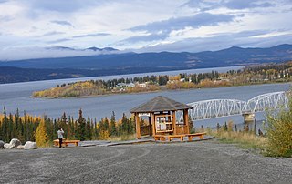
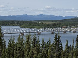
The community of Teslin(/'tɛs.lɪn/ TESS-lin) includes the Village of Teslin in Yukon, Canada. Teslin is situated at historical Mile 804 on the Alaska Highway along Teslin Lake. The Hudson's Bay Company established a small trading post at Teslin in 1903.
Yukon Energy Corporation is a Crown corporation that is the primary producer of electricity in the Canadian territory of Yukon. It also distributes electricity to a small number of locations not served by the privately-owned ATCO Electric Yukon. YEC was established in 1987 to take over the Yukon assets of the Northern Canada Power Commission and is currently organised as a subsidiary of the Yukon Development Corporation. The company's headquarters is in Whitehorse, Yukon near the Whitehorse Rapids hydroelectric generating station.
Atlin was a provincial electoral district in the Canadian province of British Columbia. It made its first appearance on the hustings in the 10th provincial general election in 1903 and last appeared in the 34th provincial general election in 1986, after which it was merged with the Skeena riding and was succeeded by Bulkley Valley-Stikine.
The Atlin Volcanic Field, also called the Llangorse Volcanic Field and the Surprise Lake Volcanic Field, is a group of late-Pleistocene to Holocene cinder cones that lies on the Teslin Plateau east of Atlin Lake, Canada. The largest volcanic feature is the 1880-m-high Ruby Mountain which has been partially dissected by Pleistocene and post-Wisconsin glaciation. Two basaltic cinder cones at the heads of Cracker Creek and Volcanic Creek lie within glacially dissected U-shaped valleys and may be of postglacial age.

CIAY-FM, branded as Life 100.7, is a Christian radio station in Whitehorse, Yukon, Canada. CIAY-FM broadcasts at 100.7 FM airing a combination of religious programming and Contemporary Christian music.

The Stikine Country, also referred to as the Stikine District or simply "the Stikine", is one of the historical geographic regions of the Canadian province of British Columbia, located inland from the central Alaska Panhandle and comprising the basin of the Stikine River and its tributaries. The term Stikine–Iskut is also fairly common to describe the area, and references the Iskut River, the Stikine's largest tributary and describable as its south fork.
The Atlin District, also known as the Atlin Country, is a historical region located in the far northwestern corner of the Canadian province of British Columbia, centered on Atlin Lake and the gold-rush capital of the region, the town of Atlin. The term "Atlin District" was also used synonymously with the official administrative area named the Atlin Mining District, established during the gold-mining heyday contemporaneous with the Klondike Gold Rush. The region also includes adjoining Teslin and Tagish Lakes and the Bennett Lake area in the narrow strip of BC separating the Alaska Panhandle from the Yukon. The Atlin District is currently part of the Stikine Region in the regional district system. The communities of the Atlin Lakes district, as the area is casually called, are referred to in national weather reports as "the Southern Lakes", as in "Whitehorse and the Southern Lakes", although this also includes towns on the Yukon end of the lakes.
The Atsutla Range is a granitic mountain range on the Kawdy Plateau in northern British Columbia, Canada. The Atsutla Range lies south of the Yukon border in between Teslin Lake and the Stewart-Cassiar Highway, roughly 120 km (75 mi) north-northeast of Dease Lake.
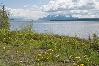
Teslin Lake is a large lake spanning the border between British Columbia and Yukon, Canada. It is one of a group of large lakes in the region of far northwestern BC, east of the upper Alaska Panhandle, which are the southern extremity of the basin of the Yukon River, and which are known in Yukon as "the Southern Lakes". The lake is fed and drained primarily by the Teslin River, south and north, but is also fed from the east by the Jennings River and the Swift River, and from the west by the Hayes River.

The Yukon Plateau is a plateau located in the Yukon Territory, comprising much of the central and southern Yukon Territory and the far northern part of British Columbia, Canada between Tagish Lake (W) and the Cassiar Mountains (E) and north of the Nakina River.
The Nisutlin Plateau is a sub-plateau, of the Yukon Plateau physiographic section, in northern British Columbia, Canada, extending east from Teslin Lake to the Cassiar Mountains.
The Swift River is a river that begins in Yukon Territory and flows southwest into British Columbia to its mouth at the east side of Teslin Lake on the Teslin River system. The river drains the uppermost portion of the Cassiar Mountains and in its lower reaches traverses the Nisutlin Plateau, which lies along the east side of Teslin Lake north of the mouth of the Jennings River, which is to the south of the Swift.
The Jennings River is a river in far northern British Columbia, Canada. It is approximately 150 kilometres (93 mi) long. The river was named for William T. Jennings (1846-1906), a civil engineer who, in 1897, assessed various road and railroad routes from the Pacific Ocean to the Yukon.
The Taku River Tlingit First Nation are the band government of the Inland Tlingit in far northern British Columbia, Canada and also in Yukon. They comprise two ḵwaan (tribes) of the Tlingit people, who are otherwise coastal, the Áa Tlein Ḵwáan of the Atlin Lake area and the Deisleen Ḵwáan of Teslin Lake, whose main focus is the Teslin Tlingit Council in Teslin, Yukon. Their band offices are in Atlin, British Columbia.
Teslin is the anglicized form of the name of the Deisleen Ḵwáan of the Tlingit people, one of two ḵwáan that are today incorporated as the Teslin Tlingit Council government in the Yukon Territory of northern Canada. As a term it may also refer to:

The Stikine Region is an unincorporated area in northwestern British Columbia, Canada. It is the only area in the province that is not part of a regional district. The Stikine Region was left unincorporated following legislation that established the province's regional districts in 1968 and is not classified as a regional district. It contains no municipal governments which normally constitute the majority of seats on the boards of regional districts. There is only one local planning area, the Atlin Community Planning Area, which was combined in 2009 with the Atlin Community Improvement District to provide fire, landfill, water, streetlighting, sidewalks and advisory land use services. All other services not provided privately are administered directly by various provincial government ministries. The area around Dease Lake, formerly in the Stikine Region, is now within the boundaries of the Regional District of Kitimat–Stikine following a boundary amendment in 2008.