
The Dakelh or Carrier are the indigenous people of a large portion of the Central Interior of British Columbia, Canada. Another name the Dakelh/Carrier call themselves is Yinka Dene, the Babine-Witsuwitʼen-speaking bands prefer the equivalent Yinka Whut'en.
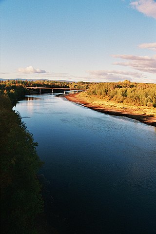
The Nechako River arises on the Nechako Plateau east of the Kitimat Ranges of the Coast Mountains of British Columbia, Canada, and flows north toward Fort Fraser, then east to Prince George where it enters the Fraser River. "Nechako" is an anglicization of netʃa koh, its name in the indigenous Carrier language which means "big river".

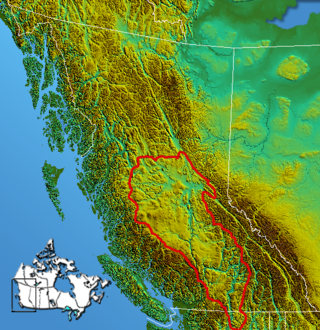
British Columbia is the westernmost province of Canada, bordered by the Pacific Ocean. With an area of 944,735 km2 (364,764 sq mi) it is Canada's third-largest province. The province is almost four times the size of the United Kingdom and larger than every United States state except Alaska. It is bounded on the northwest by the U.S. state of Alaska, directly north by Yukon and the Northwest Territories, on the east by Alberta, and on the south by the U.S. states of Washington, Idaho, and Montana. Formerly part of the British Empire, the southern border of British Columbia was established by the 1846 Oregon Treaty. The province is dominated by mountain ranges, among them the Canadian Rockies but dominantly the Coast Mountains, Cassiar Mountains, and the Columbia Mountains. Most of the population is concentrated on the Pacific coast, notably in the area of Vancouver, located on the southwestern tip of the mainland, which is known as the Lower Mainland. It is the most mountainous province of Canada.
The Interior Plateau comprises a large region of the Interior of British Columbia, and lies between the Cariboo and Monashee Mountains on the east, and the Hazelton Mountains, Coast Mountains and Cascade Range on the west. The continuation of the plateau into the United States is known there as the Columbia Plateau.

The Cariboo Mountains are the northernmost subrange of the Columbia Mountains, which run down into the Spokane area of the United States and include the Selkirks, Monashees and Purcells. The Cariboo Mountains are entirely within the province of British Columbia, Canada. The range is 7,700 square kilometres (3,000 sq mi) in area and about 245 km in length (southeast–northwest) and about 90 km at its widest (southwest–northeast).
The Omineca Mountains, also known as "the Ominecas", are a group of remote mountain ranges in the Boreal Cordillera of north-central British Columbia, Canada. They are bounded by the Finlay River on the north, the Rocky Mountain Trench on the east, the Nation Lakes on the south, and the upper reaches of the Omineca River on the west. They form a section of the Continental Divide, that, in this region, separates water drainage between the Arctic and Pacific Oceans. The lower course of the Omineca River flows through the heart of the range. To the south of the Ominecas is the Nechako Plateau, to the west the Skeena Mountains and Hazelton Mountains, to the north the Spatsizi Plateau and the Stikine Ranges, while east across the Rocky Mountain Trench are the Muskwa Ranges.

The Hazelton Mountains are a grouping of mountain ranges on the inland lee of the Kitimat Ranges of the Coast Mountains in northwestern British Columbia, Canada, spanning the area of Hazelton south to the Nechako Reservoir. Defined by the British Columbia geographic names office, they span from the Nass River to the Nechako Plateau, and between the Coast Mountains and the Bulkley River, they are considered by geographers to be part of the Interior Mountains complex, though in local perspective they are considered to be part of the Coast Mountains. They are neighboured on the west by the Kitimat Ranges and on the east by the southernmost section of the Skeena Mountains; beyond the Nass River, which is their northern boundary, are the Boundary Ranges of the Coast Mountains. To their southeast is the Nechako Plateau, including the Quanchus Range on the near-island between Ootsa and Eutsuk Lakes of the Nechako Reservoir.

The British Columbia Interior, popularly referred to as the BC Interior or simply the Interior, is a geographic region of the Canadian province of British Columbia. While the exact boundaries are variously defined, the British Columbia Interior is generally defined to include the 14 regional districts that do not have coastline along the Pacific Ocean or Salish Sea, and are not part of the Lower Mainland. Other boundaries may exclude parts of or even entire regional districts, or expand the definition to include the regional districts of Fraser Valley, Squamish–Lillooet, and Kitimat–Stikine.

The Kenney Dam is a rock-fill embankment dam on the Nechako River in northwestern British Columbia, built in the early 1950s. The impoundment of water behind the dam forms the Nechako Reservoir, which is also commonly known as the Ootsa Lake Reservoir. The dam was constructed to power an aluminum smelter in Kitimat, British Columbia by Alcan, although in the late 1980s the company increased their economic activity by selling excess electricity across North America. The development of the dam caused various environmental problems along with the displacement of the Cheslatta T'En First Nation, whose traditional land was flooded.
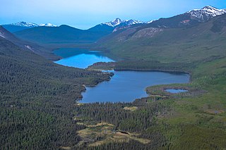
The Nechako Reservoir, sometimes called the Ootsa Lake Reservoir, is a hydroelectric reservoir in British Columbia, Canada that was formed by the Kenney Dam making a diversion of the Nechako River through a 16-km intake tunnel in the Kitimat Ranges of the Coast Mountains to the 890 MW Kemano Generating Station at sea level at Kemano to service the then-new Alcan aluminum smelter at Kitimat. When it was constructed on the Nechako River in 1952, it resulted in the relocation of over 75 families. It was one of the biggest reservoirs built in Canada until the completion of the Columbia Treaty Dams and the W.A.C. Bennett Dam that created Lake Williston. The water level may swing 10 feet between 2790 and 2800 feet.

Churn Creek is a tributary of the Fraser River in the Canadian province of British Columbia.

The Fraser Plateau is an intermontane plateau. It is one of the main subdivisions of the Interior Plateau located in the Central Interior of British Columbia.
The Quanchus Range is a subrange of the Nechako Plateau in the Interior of British Columbia, Canada, located on the north end of Tweedsmuir North Provincial Park and Protected Area. It is almost completely an island after the creation of the Nechako Reservoir. Its two main summits are Michel Peak (2260m) and Tweedsmuir Peak (2194m).
The Nechako Canyon, also known as the Grand Canyon of the Nechako, is a canyon on the Nechako River in the Central Interior of British Columbia, Canada, located between Cheslatta Falls and Knewstubb Lake, which lies immediately above the Kenny Dam, which forms the Nechako Reservoir. Cheslatta Falls, 18 m in height, is the final leg of the Cheslatta River and cascades into the Nechako at its confluence. The river-bed in the canyon is mostly dry due to the Nechako's diversion. The canyon is carved into a lava plateau and features erosive formations such as rock walls, overhanging cliffs, pinnacles and other formations, and is protected by the Nechako Canyon Protected Area, which includes Cheslatta Falls.
Nechako Canyon Protected Area is a protected area of the BC Parks system, located on the Nechako River between Knewstubb Lake and Cheslatta Falls at the mouth of the Cheslatta River. The Nechako Canyon, also known as the Grand Canyon of the Nechako, is carved into a lava plateau and features erosive formations such as rock walls, overhanging cliffs, pinnacles and other formations, and the protected area includes Cheslatta Falls.
The Cheslatta Carrier Nation or Cheslatta T'En, of the Dakelh or Carrier people (Ta-cullies, meaning "people who go upon water" is a First Nation of the Nechako River at the headwaters of the Fraser River.
The Cheslatta River is a tributary of the Nechako River, one of the main tributaries of the Fraser River, in the Canadian province of British Columbia. It flows through the Nechako Plateau. Before the construction of Kenney Dam in the early 1950s the Cheslatta was a minor tributary of the Nechako. Today the Nechako River is dry above the Cheslatta, which provides all its source water.

Cheslatta Lake is a large freshwater lake located between François Lake and the western end of the Nechako Reservoir, Range 4 Coast Land District. It is in the Regional District of Bulkley-Nechako, British Columbia.
Mount Swannell, 1821 m (5974 ft), prominence 771 m, is a mountain in the Fawnie Range of the Nechako Plateau in the Central Interior region of British Columbia, Canada. It is located to the south of the outlet of the Entiako River into Natalkuz Lake, which is part of the Nechako Reservoir. The northernmost of the summits of the Fawnie Range and is in the northeastern end of Entiako Provincial Park, it is the only named summit of the Fawnie Range within the park.
The Fawnie Range is a small hill-range located to the south of the Ootsa Lake reservoir and to the north of the West Road River in the Nechako Plateau region of the Central Interior of British Columbia, Canada. The northwest part of the park is within Entiako Provincial Park and includes Mount Swannell,, one of the range's main summits, overlooking Natalkuz Lake from the south. Other named summits include Tutial Mountain, Fawnie Dome and Fawnie Nose, the highest summit in the range.
