As a part of the Mount Edziza volcanic complex, the Kitsu Plateau is drained entirely by streams within the Stikine River watershed.[2][9] The only named stream on the plateau is Kitsu Creek, which originates on the northern flank of Kitsu Peak in the Spectrum Range and flows northwest then north into Mess Creek, a tributary of the Stikine River.[5][10][11] Several small unnamed streams flow into Kitsu Creek and the neighbouring valleys of Mess Creek, Raspberry Creek and Nagha Creek; Raspberry Creek drains into Mess Creek whereas Nagha Creek drains into Kitsu Creek just northeast of Mess Lake.[11][12][13]
Structure
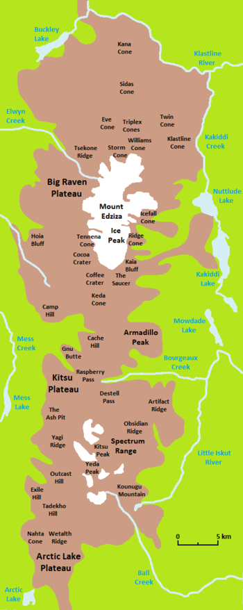
The western, northern and southern edges of the Kitsu Plateau are marked by steep cliffs forming the Mess Creek Escarpment, the southern side of Raspberry Creek valley and the northern side of Nagha Creek valley, respectively.[2][5] At the Mess Creek Escarpment, the Kitsu Plateau rises more than 910 metres (3,000 feet) above Mess Lake in Mess Creek valley; Mess Lake has an elevation below 760m (2,500ft) whereas the Mess Creek Escarpment reaches an elevation of more than 1,700m (5,500ft).[2] The plateau surface is barren of vegetation, but at lower elevations the surrounding valleys contain white spruce, lodgepole pine and trembling aspen forests.[2][14]
Landforms
The Kitsu Plateau is dominated by the Mess Lake Lava Field, which extends from Raspberry Creek in the north to Nagha Creek in the south.[2][15] It covers an area of around 18 square kilometres (6.9 square miles) and contains three pyroclastic cones which were the sources of lava flows that travelled westward towards the Mess Creek Escarpment.[15] The oldest cone, sometimes referred to by the numeronym ML-1, is at the northern end of the lava field, whereas the second oldest cone, ML-2, is at the southern end of the lava field.[16] Both cones are covered by tundra vegetation and have been slightly rounded by erosion, although their craters are still recognizable. The Ash Pit, sometimes referred to by the numeronym ML-3, is the youngest and southernmost eruptive centre of the Mess Lake Lava Field.[16] It lies on the steep southern slope of the Kitsu Plateau inside Nagha Creek valley and has been described as a pyroclastic cone or a conical explosion crater.[5][17]
Geology
Stratigraphy
The Kitsu Plateau is subdivided into at least five geological formations, each being the product of a distinct period of volcanic activity.[4][5] These periods of volcanic activity occurred during three magmatic cycles of the Mount Edziza volcanic complex; each cycle began with the effusion of alkali basalt and culminated with the eruption of lesser volumes of felsic magma.[18] The two oldest geological formations comprising the Kitsu Plateau are the Raspberry and Armadillo formations, which were deposited by volcanic eruptions during the first magmatic cycle between 7.5 and 6 million years ago. Overlying these two geological formations are the Nido and Spectrum formations, which were deposited between 6 and 3 million years ago during the second magmatic cycle. The fifth oldest geological formation comprising the Kitsu Plateau is the Big Raven Formation, which was deposited during the fifth magmatic cycle in the last 20,000 years.[4][5]
The Raspberry Formation is exposed on the lower northern, western and southwestern sides of the Kitsu Plateau.[5] It has an elevation of less than 1,310m (4,300ft) along the Mess Creek Escarpment and consists of flat-lying basaltic lava flows interbedded with scoria.[19] More than 180m (590ft) of Raspberry lava flows are exposed in the Mess Creek Escarpment, most of which were erupted from a shield volcano that formed on a Late Mioceneerosion surface.[20][21] These lava flows travelled westward into the ancestral valley of Mess Creek and originated from vents north of Raspberry Pass which were subsequently buried under younger volcanic deposits. A minimum age for the timing of Raspberry volcanism is 7.4–6.2 million years.[21]
Armadillo Formation
Basaltic lava flows of the 6.3-million-year-old Armadillo Formation are exposed on the northern side of the plateau and along the Mess Creek Escarpment on the western side of the plateau where they overlie basaltic lava flows of the Raspberry Formation.[4][5] Armadillo basalt flows are interbedded with air-fallpumice and ash flows of trachytic and comenditic compositions.[21][22] They were highly fluid and mobile at the time of their eruption as evidenced by their extreme persistence and relatively narrow thicknesses; individual basalt flows of this geological formation are less than 3m (9.8ft) thick. The source of these flows was probably a cluster of vents further to the north called Sezill Volcano which may have been active prior to the onset of Armadillo volcanism.[22] In contrast, the interbedded air-fall pumice and ash flows probably originated from the more than 4km (2.5mi) in diameter Armadillo Peak caldera northeast of the Kitsu Plateau.[6][21]
Nido Formation
Overlying the Armadillo Formation is the Kounugu Member, which is the only stratigraphic unit of the Nido Formation comprising the Kitsu Plateau.[5] It consists of basaltic lava flows, flow breccia and agglutinate which were erupted 4.4 million years ago from at least four eruptive centres; these eruptive centres have since been deeply eroded and buried under younger volcanic deposits.[5][23] At least some of the Kounugu lava flows comprising the Kitsu Plateau may have originated from Swarm Peak further to the east, which issued lava that travelled westward; remains of the Swarm Peak eruptive centre are in the form of north-trending fissure swarms.[24] Lava from the Swarm Peak eruptive centre is exposed along the Mess Creek Escarpment where it overlies till and glacial-fluvial gravel derived from the Armadillo Formation.[25]
Spectrum Formation
The Kounugu Member is overlain by the 3.1-million-year-old Spectrum Formation, which is exposed along the Mess Creek Escarpment on the western side of the plateau and at the southern and eastern ends of the plateau.[4][5] This geological formation largely consists of comendite, pantellerite and pantelleritic trachyte; all three volcanic rocks comprise lava domes, lava flows and minor breccia and ash flow deposits.[5] Spectrum trachyte flows on the Kitsu Plateau are the most distal remnants of the main Spectrum Dome and are relatively thin compared to those forming the adjacent Spectrum Range.[10] These trachyte flows are overlain by alkali basalt of the Kitsu Member, which is mainly exposed at the southern end of the Kitsu Plateau and along the western edge of the plateau.[5] This alkali basalt is in the form of lava flows and likely originated from vents of the Spectrum Dome which have since been destroyed by erosion.[26]
Big Raven Formation
The Big Raven Formation is the youngest and uppermost geological formation comprising the Kitsu Plateau, consisting of hawaiite and alkali basalt in the form of lava flows, lava bombs, agglutinate and air-fall tephra.[5] These volcanic rocks were deposited by eruptions during the Holocene and mainly comprise the Mess Lake Lava Field, one of the three Big Raven lava fields of the Mount Edziza volcanic complex.[4][5][27] Alkali basalt flows from the two oldest pyroclastic cones in the Mess Lake Lava Field, ML-1 and ML-2, most likely cascaded over the Mess Creek Escarpment into Mess Creek valley, but no evidence of this phenomenon has been found on or below the escarpment.[15] The Ash Pit, which may be the youngest eruptive centre of the entire Mount Edziza volcanic complex, was the source of a 6.5km (4.0mi) long and 2.5km (1.6mi) wide hawaiitic air-fall tephra deposit that extends to the north-northeast on the Kitsu Plateau.[5][28] It was also the source of a hawaiitic lava flow that travelled 3.5km (2.2mi) to the northwest through Nagha Creek valley towards Mess Lake.[5] Residual heat from The Ash Pit eruption may have resulted in the formation of the Mess Lake Hot Springs2.5km (1.6mi) to the west in Mess Creek valley.[2][29]
The name of the plateau became official on January 2, 1980, and was adopted on the National Topographic System map 104G/10 after being submitted to the BC Geographical Names office by the Geological Survey of Canada.[1][33] It means 'northern lights' in the Tahltan language and was likely chosen due to the plateau's association with Kitsu Creek and Kitsu Peak, whose names were also adopted on January 2, 1980, on the National Topographic System maps 104G/10 and 104G/7, respectively.[1][34][35]
Provincial park
The Kitsu Plateau lies at the southern end of Mount Edziza Provincial Park, a protected area founded in 1972 to preserve the volcanic landscape.[2][14] This remote wilderness area of northwestern British Columbia is not accessible by motorized vehicles to help protect the very sensitive environment. Instead, access is mainly via aircraft or unmaintained hiking trails that cross creeks.[14] Mount Edziza Provincial Park covers 266,180 hectares (657,700 acres), making it one of the largest provincial parks in British Columbia.[14][36] Hunting, camping, fishing, hiking, wildlife viewing and nature studying are some of the activities available in Mount Edziza Provincial Park.[14]
Wildlife in the area includes moose, caribou, mountain goats, stone sheep, wolves, bears, squirrels, owls, ptarmigans, ravens, gyrfalcons, grouse and migratory songbirds. The climate is characterized by warm summers and cold, snowy winters; temperatures are warmest in mid-summer during the day when they may hit the 30 degrees Celsius (86 degrees Fahrenheit) range. However, temperatures can drop below freezing during summer nights, making snow or freezing rain a possibility at any time of the year.[14]
Accessibility
False colour image of the Kitsu Plateau with the Mess Creek Escarpment in the foreground
From near the Eastman Creek Rest Area south of Kinaskan Lake on the Stewart–Cassiar Highway, the historic Yukon Telegraph Trail extends about 15km (9.3mi) west to the Little Iskut River. From there, it enters Mount Edziza Provincial Park and continues another 15km (9.3mi) west along Bourgeaux Creek through Raspberry Pass.[37] The telegraph trail then continues to the northwest through Raspberry Creek valley along the northern edge of the Kitsu Plateau for about 15km (9.3mi) to Mess Creek valley.[2][37] Only short segments of the Yukon Telegraph Trail are still passable, having been mostly overgrown since maintenance of the trail ended in 1936.[38]
The Kitsu Plateau can be accessed via charter aircraft from Dease Lake and Tatogga Lake, the latter of which is near the community of Iskut.[14][38][39][40] Private aircraft are prohibited from landing on the Kitsu Plateau lava flows, but Mess Lake is large enough to be used by float-equipped aircraft. Landing on the lake with a private aircraft requires a letter of authorization from the BC Parks Stikine Senior Park Ranger.[14]
This page is based on this Wikipedia article Text is available under the CC BY-SA 4.0 license; additional terms may apply. Images, videos and audio are available under their respective licenses.


