
The 2002 Yukon general election was held on November 4, 2002, to elect members of the 31st Yukon Legislative Assembly in Yukon, Canada.
The Teslin Tlingit Council (TTC) is a First Nation band government in the central Yukon in Canada, located in Teslin, Yukon along the Alaska Highway and Teslin Lake. The language originally spoken by the Teslin Tlingit or Deisleen Ḵwáan is Tlingit. Together with the Taku River Tlingit or Áa Tlein Ḵwáan around Atlin Lake of the Taku River Tlingit First Nation in British Columbia, and carcross tagish first nation or natasaaheeni, they comprise the Inland Tlingit.
Southern Lakes was an electoral district in rural Yukon which returned a member to the Legislative Assembly of the Yukon in Canada. It was one of the eight rural ridings in the Yukon at the time.
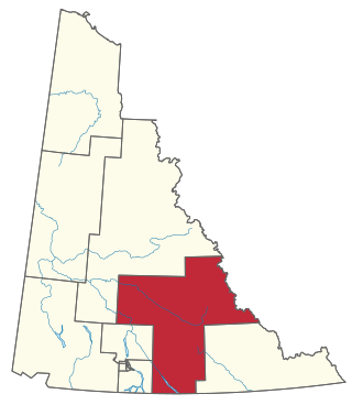
Pelly-Nisutlin is an electoral district which returns a member to the Legislative Assembly of the Yukon Territory in Canada. It was created in 2002 out of the districts of Faro and Ross River-Southern Lakes. The riding includes the communities of Teslin, Faro, Ross River, Little Salmon, and Johnsons Crossing. It encompasses the traditional territory of the Teslin Tlingit Council and the Ross River Dena Council of the Kaska Dena. Pelly-Nisutlin is bordered by the rural ridings of Mayo-Tatchun, Lake Laberge, Mount Lorne-Southern Lakes, and Watson Lake.

The Cassiar Mountains are the most northerly group of the Northern Interior Mountains in the Canadian province of British Columbia and also extend slightly into the southernmost Yukon Territory. They lie north and west of the Omineca Mountains, west of the northernmost Rockies and the Rocky Mountain Trench, north of the Hazelton Mountains and east of the Boundary Ranges. They form a section of the Continental Divide, that, in this region, separates water drainage between the Arctic and Pacific Oceans. Physiographically, they are a section of the larger Yukon-Tanana Uplands province, which in turn are part of the larger Intermontane Plateaus physiographic division.
The Stikine Ranges are a group of mountain ranges and mountainous plateaus in northwestern British Columbia, Canada. They are the northernmost subdivision of the Cassiar Mountains and among the least explored and most undeveloped parts of the province.
Marian Horne is a Canadian politician, who represented the rural Yukon electoral district of Pelly-Nisutlin in the Yukon Legislative Assembly from 2006 to 2011. She is a member of the Yukon Party.
The Atsutla Range is a granitic mountain range on the Kawdy Plateau in northern British Columbia, Canada. The Atsutla Range lies south of the Yukon border in between Teslin Lake and the Stewart-Cassiar Highway, roughly 120 km (75 mi) north-northeast of Dease Lake.
Dean Hassard is a Canadian politician. He represented the electoral district of Pelly-Nisutlin in the Yukon Legislative Assembly as a member of the Yukon Party from 2002 to 2006.
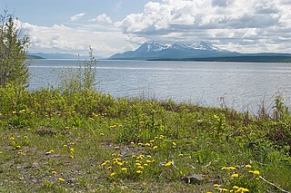
Teslin Lake is a large lake spanning the border between British Columbia and Yukon, Canada. It is one of a group of large lakes in the region of far northwestern BC, east of the upper Alaska Panhandle, which are the southern extremity of the basin of the Yukon River, and which are known in Yukon as "the Southern Lakes". The lake is fed and drained primarily by the Teslin River, south and north, but is also fed from the east by the Jennings River and the Swift River, and from the west by the Hayes River.

The Stikine Plateau is a plateau in northern British Columbia, Canada. It lies between the Boundary Ranges of the Coast Mountains on the west and southwest and the Cassiar Mountains along its northeast, and between the Skeena Mountains on its south and southeast and the Jennings and Nakina Rivers on the north.

The Yukon Plateau is a plateau located in the Yukon Territory, comprising much of the central and southern Yukon Territory and the far northern part of British Columbia, Canada between Tagish Lake (W) and the Cassiar Mountains (E) and north of the Nakina River.
The Swift River is a river that begins in Yukon Territory and flows southwest into British Columbia to its mouth at the east side of Teslin Lake on the Teslin River system. The river drains the uppermost portion of the Cassiar Mountains and in its lower reaches traverses the Nisutlin Plateau, which lies along the east side of Teslin Lake north of the mouth of the Jennings River, which is to the south of the Swift.
The Jennings River is a river in far northern British Columbia, Canada. It is approximately 150 kilometres (93 mi) long. The river was named for William T. Jennings (1846-1906), a civil engineer who, in 1897, assessed various road and railroad routes from the Pacific Ocean to the Yukon.

The Teslin Plateau is a sub-plateau, of the Yukon Plateau physiographic section, in northern British Columbia, Canada, located north of the Nakina River between Atlin Lake and Teslin Lake.
The Taku Plateau is a sub-plateau of the Stikine Plateau in the far northwestern Interior of British Columbia, Canada. It lies to the south of the Teslin Plateau, part of the Yukon Plateau and to the southeast of the Yukon Plateau's other major sub-area within British Columbia, the Tagish Highland. Immediately northeast is the Kawdy Plateau and to the northwest of the Nahlin Plateau. The Inklin River forms the plateau's southwestern boundary with the northwestern extremities of the Tahltan Highland, beyond which are the Boundary Ranges. Very mountainous, its highest summit is Nahlin Mountain.
Teslin is the anglicized form of the name of the Deisleen Ḵwáan of the Tlingit people, one of two ḵwáan that are today incorporated as the Teslin Tlingit Council government in the Yukon Territory of northern Canada. As a term it may also refer to:
Stacey Hassard is a Canadian politician, who was elected to in the Yukon Legislative Assembly in the 2011 election. He represents the electoral district of Pelly-Nisutlin as a member of the Yukon Party caucus. He is a former leader of the Yukon's Official Opposition and the former interim leader of the Yukon Party.
The Wolf River is a river in Yukon, Canada. It is in the Bering Sea drainage basin and is a left tributary of the Nisutlin River.
