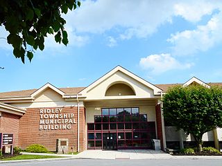
Ridley Township is a township in Delaware County, Pennsylvania. The population was 30,768 at the 2010 census. Ridley Township contains the census designated places of Folsom and Woodlyn along with the unincorporated communities of Crum Lynne and Holmes and a portion of Secane.

Blue Mountain, Blue Mountain Ridge, or the Blue Mountains of Pennsylvania, is a ridge of the Appalachian Mountains in eastern Pennsylvania. Forming the southern and eastern edge of the Ridge-and-Valley Appalachians physiographic province in Pennsylvania, Blue Mountain extends 150 miles (240 km) from the Delaware Water Gap on the New Jersey border in the east to Big Gap in Franklin County in south-central Pennsylvania at its southwestern end.

Raven Rock is an unincorporated community and hamlet along the Delaware River approximately three miles (4.8 km) north of Stockton along New Jersey Route 29. The hamlet was known earlier as Saxtonville. It is located within Delaware Township in Hunterdon County, New Jersey, United States. It is the site of Bull's Island Recreation Area. The rock outcrop for which it is named is the southwest corner of the Hunterdon Plateau.

Pennsylvania's fifth congressional district encompasses all of Delaware County, an exclave of Chester County, a small portion of southern Montgomery County and a section of southern Philadelphia. Democrat Mary Gay Scanlon represents the district.

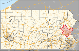
Pennsylvania's 7th congressional district includes all of Carbon, Lehigh, and Northampton Counties; and parts of Monroe County. The district is represented by Democrat Susan Wild.

Delaware Route 261 (DE 261) and Pennsylvania Route 261 (PA 261), also known as Foulk Road, is a 6.63-mile (10.67 km) state highway running through Delaware and Pennsylvania. DE 261 runs 4.37 miles (7.03 km) through New Castle County, Delaware from an interchange with U.S. Route 202 (US 202) and DE 141 north of Interstate 95 (I-95) near Fairfax, Delaware, a community north of Wilmington, northeast to the Pennsylvania state line. The road runs through suburban areas of Brandywine Hundred as a four-lane road south of DE 92 and a two-lane road north of DE 92. At the Pennsylvania state line, Foulk Road becomes PA 261 and continues 2.26 miles (3.64 km) through Bethel Township in Delaware County, intersecting PA 491 in Booths Corner before ending at an interchange with US 322.

Pennsylvania Route 491 (PA 491) and Delaware Route 491 (DE 491) is a state highway starting in Delaware County, Pennsylvania and ending in New Castle County, Delaware. Also known as Naamans Creek Road, the route runs from U.S. Route 202 (US 202) in Concord Township east to the Delaware border in Lower Chichester Township. In the state of Delaware, the highway runs for 0.36 mi (0.58 km) as a connector between the Pennsylvania border and DE 92 near Claymont, Delaware. PA 491 runs closely parallel to the Delaware border throughout its route. It intersects PA 261 in the Booths Corner section of Bethel Township. The western portion of PA 491 was first designated as part of Legislative Route 135 in 1911. In the 1920s, the Delaware portion of road was built as a state highway while PA 491 was created in 1928.
The Central Delaware Valley AVA is an American Viticultural Area located in southeastern Pennsylvania and New Jersey. The wine appellation includes 96,000 acres (38,850 ha) surrounding the Delaware River north of Philadelphia. Its southern boundary is near Titusville, New Jersey, just north of Trenton, and its northern border is near Musconetcong Mountain. A variety of Vitis vinifera and Vitis labrusca grape varieties can be grown in the area. It has a hot-summer humid continental climate (Dfa) and is in hardiness zones 6b and 7a.
Naaman is an unincorporated community in New Castle County, Delaware, United States. It is 0.5 mile south of the Pennsylvania state line and 7.5 miles northeast of Wilmington. Naaman is located at the intersection of Delaware Route 92 and Ridge Road, northeast of Claymont.
Stanton is an unincorporated community in New Castle County, Delaware, United States, near the confluence of the Red Clay and White Clay Creeks. It is located in the southern end of Mill Creek Hundred.
Mathews Corners is an unincorporated community in New Castle County, Delaware, United States. Mathews Corners is located on Delaware Route 299, just west of Delaware Route 9, to the southeast of Odessa.

Prices Corner is an unincorporated community in New Castle County, Delaware, United States. Prices Corner is located at the intersection of Delaware Route 2 and Delaware Route 141, west of Wilmington. The Prices Corner Shopping Center is located in Prices Corner.

Booths Corner is an unincorporated community in Bethel Township in Delaware County, Pennsylvania, United States. Booths Corner is located at the intersection of Pennsylvania Route 261 and Pennsylvania Route 491.
Lodi is an unincorporated community in Tinicum Township in Bucks County, Pennsylvania, United States. Lodi is located along Lodi Hill Road just southwest of an intersection with Pennsylvania Route 32 along the Delaware River in the northern corner of Tinicum Township near the Bridgeton Township border.

Chelsea is an unincorporated community in Bethel Township in Delaware County, Pennsylvania, United States. Chelsea is located at the intersection of Concord Road, Chelsea Road, Foulk Road, and Valley Brook Road in the northern part of the township.
Corner Ketch is an unincorporated community in New Castle County, Delaware, United States. Corner Ketch is located at the intersection of Corner Ketch Road and Doe Run Road, north of Newark.
Llanerch is an unincorporated community on the border of Haverford Township and Upper Darby Township in Delaware County, Pennsylvania, United States. Llanerch is located at the intersection of U.S. Route 1, Pennsylvania Route 3, and Darby Road.
The Pennsylvania State Game Lands Number 52 are Pennsylvania State Game Lands in Berks and Lancaster Counties, Pennsylvania that provide the public with providing hunting, bird watching, and other activities.
The Pennsylvania State Game Lands Number 182 are Pennsylvania State Game Lands in Berks County in Pennsylvania in the United States providing hunting, bird watching, and other activities.
Aquetong is populated place in Solebury Township, Bucks County, Pennsylvania, United States, situated along U.S. Route 202, approximately 2.9 miles (4.7 km) west of New Hope.


