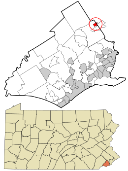
Bryn Mawr is a census-designated place (CDP), located across three townships: Radnor Township and Haverford Township, Delaware County, and Lower Merion Township, Montgomery County, Pennsylvania, United States, just west of Philadelphia along Lancaster Avenue (US-30).
Broomall is a census-designated place (CDP) in Marple Township, Delaware County, Pennsylvania, United States. The population was 10,789 at the 2010 census.
Haverford Township is a home rule municipality township in Delaware County, Pennsylvania. Haverford is named after the town of Haverfordwest in Wales, United Kingdom. It is a commuting suburb located due west of Philadelphia and is officially known as the Township of Haverford. Despite being under a home rule charter since 1977, it continues to operate under a Board of Commissioners divided into wards, as do "First Class" townships that are still under the Pennsylvania Township Code. Haverford Township was founded in 1682 and incorporated in 1911.

Ardmore is an unincorporated community and census-designated place (CDP) spanning the border between Delaware and Montgomery counties in the U.S. state of Pennsylvania. The population was 12,455 at the 2010 census and had risen to 13,566 in the 2020 Census. Ardmore is a suburb on the west side of Philadelphia, within Lower Merion Township in Montgomery County and Haverford Township in Delaware County. Originally named "Athensville" in 1853, the community and its railroad station were renamed "Ardmore" in 1873 by the Pennsylvania Railroad, on whose Main Line, west out of Philadelphia, Ardmore sits at Milepost 8.5. The Autocar Company moved its headquarters to Ardmore in 1899 and constructed a factory on the edge of the downtown area. The factory closed in 1954; during demolition in 1956, a major fire broke out that threatened the downtown area before it was extinguished. Today, Ardmore consistently ranks among the most desirable suburbs of Philadelphia.

Ponshewaing is an unincorporated community and census-designated place (CDP) in Emmet County in the U.S. state of Michigan. As of the 2010 census, the CDP had a population of 69. It is located within Littlefield Township.
Baumstown is a census-designated place in Exeter Township, Berks County, Pennsylvania, United States, located near the borough of Birdsboro. It is located at the junction of U.S. Highway 422 and Pennsylvania Route 345. As of the 2010 census the population of Baumstown was 422 residents.
Mohrsville is a census-designated place in Centre Township, Berks County, Pennsylvania, United States. It is located approximately three miles south of the borough of Shoemakersville, along the Schuylkill River. As of the 2010 census, the population was 383 residents.
Lamar is a census-designated place in Porter Township in southern Clinton County, Pennsylvania, United States. As of the 2010 census the population was 562.
Colony Park is a census-designated place in Spring Township, Berks County, Pennsylvania, United States. It is located just off U.S. 222, approximately one mile northwest of the borough of Wyomissing. As of the 2010 census, the population was 1,076 residents.
Grazierville is a census-designated place in Snyder Township, Blair County, Pennsylvania. It is located near I-99 and is approximately 1 mile to the south of the borough of Tyrone. As of the 2010 census, the population was 665 residents.
Greenwood is a census-designated place in Logan Township, Blair County, Pennsylvania. It is located near I-99 and is adjacent in the northeast to the city of Altoona. As of the 2010 census, the population was 2,458 residents. It is often considered a district of Altoona, as the addresses are listed as Altoona addresses and some of the avenues use Altoona's numbering system.
Lake Arthur Estates is a census-designated place and mobile home court located in Muddy Creek Township, Butler County, in the U.S. state of Pennsylvania. Located near the intersections of I-79 and US 422, the village is situated west of Lake Arthur, a reservoir on Muddy Creek. The community is also just west of Moraine State Park, which surrounds the lake. As of the 2010 census the population was 594.

Mingoville is an unincorporated community and census-designated place (CDP) in Walker Township, Centre County, Pennsylvania, United States. As of the 2010 census, the population was 503 residents.
Crown is a census-designated place in Farmington Township, Clarion County, in the U.S. state of Pennsylvania. The community is located along Pennsylvania Route 66 in northern Clarion County. As of the 2010 census the population was 183.

Leeper is a census-designated place (CDP) located in Farmington Township, Clarion County, in the U.S. state of Pennsylvania. The community is located at the intersections of Pennsylvania Routes 66 and 36 in northern Clarion County. As of the 2010 census the population was 158.

Marianne is a census-designated place located in Paint Township and Elk Township, Clarion County, in the U.S. state of Pennsylvania. The community is located at the intersections of Pennsylvania Route 66 and U.S. Route 322, approximately 1 mile (1.6 km) east of the borough of Shippenville and 3 miles (5 km) northwest of Clarion, the county seat. As of the 2010 census the population of Marianne was 1,167.
Coral is a census-designated place located in Center Township, Indiana County, Pennsylvania, United States. The community is located between the borough of Homer City and the community of Black Lick on U.S. Route 119. It is bordered to the north by Graceton. As of the 2010 census the population of Coral was 325.
Graceton is a census-designated place located in Center Township, Indiana County in the state of Pennsylvania. The community is located between the borough of Homer City and the community of Black Lick on U.S. Route 119. It is also located less than a mile from the other CDP of Coral. As of the 2010 census the population was 257 residents.
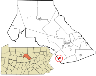
Clay is an unincorporated community and census-designated place (CDP) in Clay Township, Lancaster County, Pennsylvania, United States. It is located along U.S. Route 322 between Brickerville and Ephrata. As of the 2010 census the population was 1,559.