Collegeville, Pennsylvania

Last updated

Collegeville, Pennsylvania
Kuster Mill.JPG
Kuster Mill, built 1702 and located in nearby Skippack Township
Collegeville Montgomery County.png
Location of Collegeville in Montgomery County, Pennsylvania
USA Pennsylvania location map.svg
Red pog.svg
Collegeville
Location of Collegeville in Pennsylvania
Usa edcp location map.svg
Red pog.svg
Collegeville
Collegeville (the United States)
Coordinates: 40°11′08″N75°27′30″W / 40.18556°N 75.45833°W / 40.18556; -75.45833
CountryUnited States
StatePennsylvania
County Montgomery
Settled1684 [1]
Government
  TypeCouncil-manager
  MayorAidsand Wright-Riggins
Area
[2]
  Total1.61 sq mi (4.17 km2)
  Land1.57 sq mi (4.07 km2)
  Water0.04 sq mi (0.10 km2)
Elevation
207 ft (63 m)
Population
 (2020) [3]
  Total5,043
  Density3,208.02/sq mi (1,238.75/km2)
Time zone UTC-5 (EST)
  Summer (DST) UTC-4 (EDT)
ZIP Codes
19426, 19473
Area code(s) 610
FIPS code 42-15192
Website www.collegeville-pa.gov

Collegeville is a borough in Montgomery County, Pennsylvania, a suburb outside of Philadelphia on Perkiomen Creek. Collegeville was incorporated in 1896. It is the location of Ursinus College, which opened in 1869. The population was 5,089 at the 2010 census.

Contents

History

The area which is present day Collegeville was part of the original William Penn purchase of "All the land lying on the Pahkehoma" in 1684. In 1799, Perkiomen Bridge was constructed using funds raised from a special lottery approved by the Pennsylvania Legislature. When the first post office in this area was established in 1847, it was called Perkiomen Bridge. In 1832, the first school for primary and secondary students was established and it was later renamed Freeland Public School in 1844. In 1848, Henry A. Hunsicker built the "Freeland Seminary of Perkiomen Bridge." Village around the school became known as Freeland. In 1851, Abraham Hunsicker established the Pennsylvania Female College near present-day Glenwood Avenue. Ten years later, in 1861, the post office was moved and renamed Freeland.

When the trains first arrived in the area in 1868, there was a debate about naming of the station (Perkiomen Bridge vs Freeland). The local citizens acquired notoriety when they burned down the toll booth on the Perkiomen Bridge and threw the gate into the river. The rail company avoided any troubles by naming it "Collegeville" (the station was actually closer to the Pennsylvania Female College than either Freeland School or Perkiomen Bridge). Ursinus College was founded a year later in 1869. Thus the name "Collegeville" precedes the establishment of Ursinus College and it is actually named after the other 4-year liberal arts college (Pennsylvania Female College) which closed in 1880. Collegeville was incorporated as borough in 1896.

The Perkiomen Bridge and Perkiomen Bridge Hotel are listed on the National Register of Historic Places. [4]

Geography

Collegeville is located at 40°11′8″N75°27′30″W / 40.18556°N 75.45833°W / 40.18556; -75.45833 (40.185554, -75.458273). According to the U.S. Census Bureau, the borough has a total area of 1.6 square miles (4.1 km2), of which 1.6 square miles (4.1 km2) is land and 0.1 square miles (0.26 km2) (3.70%) is water. It has a hot-summer humid continental climate (Dfa) and average monthly temperatures range from 31.0 °F in January to 75.7 °F in July. The hardiness zone is 7a bordering upon 6b.

Economy

Collegeville and the surrounding area are rapidly growing. Collegeville is home to Ursinus College and several local businesses. Outside the borough, Pfizer's pharmaceutical division and Dow Chemical share a global research and development campus. [5] [6] There is also a GlaxoSmithKline research and development facility. The Providence Town Center, an open-air shopping and restaurant mall, is located just outside Collegeville.

Collegeville is the home of the Church House (headquarters) of the Pennsylvania Southeast Conference of the United Church of Christ.

Demographics

Historical population
CensusPop.Note
1900 611
1910 6211.6%
1920 6819.7%
1930 87828.9%
1940 97611.2%
1950 1,90094.7%
1960 2,25418.6%
1970 3,19141.6%
1980 3,4066.7%
1990 4,22724.1%
2000 4,99218.1%
2010 5,0891.9%
2020 5,043−0.9%
Sources: [7] [8] [9] [10] [3]
Presidential elections results [11]
Year Republican Democratic
2020 38.0% 1,05661.2%1,699
2016 39.1% 98655.3%1,393
2012 43.2% 1,01154.6%1,275
2008 40.2% 1,01158.8%1,478
2004 46.6% 1,00652.9%1,142
2000 50.1%85247.5% 808

As of the 2010 census, the population of the borough was 89.4% White, 4.0% Black or African American, 0.2% Native American, 3.8% Asian, and 1.9% were two or more races. 2.4% of the population were of Hispanic or Latino ancestry. [12]

As of the census [8] of 2000, there were 8,032 people, 1,408 households, and 1,010 families residing in the borough. The racial makeup of the borough was 61.83% White, 31.19% African American, 0.10% Native American, 2.13% Asian, 0.01% Pacific Islander, 3.93% from other races, and 0.81% from two or more races. Hispanic or Latino of any race were 5.13% of the population. The 2000 census apparently included the population of State Correctional Institution - Graterford, located in nearby Skippack Township.

There were 1,408 households, out of which 38.3% had children under the age of 18 living with them, 61.9% were married couples living together, 7.2% had a female householder with no husband present, and 28.2% were non-families. 21.4% of all households were made up of individuals, and 5.7% had someone living alone who was 65 years of age or older. The average household size was 2.67 and the average family size was 3.17.

In the borough the population was spread out, with 12.9% under the age of 18, 17.6% from 18 to 24, 42.9% from 25 to 44, 21.4% from 45 to 64, and 5.2% who were 65 years of age or older. The median age was 35 years. For every 100 females there were 240.2 males. For every 100 females age 18 and over, there were 275.6 males.

The median income for a household in the borough was $77,499, and the median income for a family was $90,733. Males had a median income of $40,185 versus $39,236 for females. The per capita income for the borough was $23,080. About 1.0% of families and 2.0% of the population were below the poverty line, including none of those under age 18 and 2.1% of those age 65 or over.

Politics and government

Collegeville has a city manager form of government with a mayor and a seven-member borough council. The current mayor is Aidsand Wright-Riggins.

The borough is part of the Fourth Congressional District (represented by Rep. Madeleine Dean), the 150th State House District (represented by Rep. Joe Webster) and the 24th State Senate District (represented by Sen. Tracy Pennycuick).

State Correctional Institution – Phoenix is a state prison of the Pennsylvania Department of Corrections in Skippack Township; it has a Collegeville postal address. [13] [14]

Education

The borough of Collegeville is served by the Perkiomen Valley School District. [15] Some nearby areas outside of the borough limits are served by Methacton School District [16] and Spring-Ford Area School District. [17]

There is also one private parochial school, Holy Cross Regional Catholic School, which serves grades K-8. Holy Cross was formed in 2012 by the merger of St. Eleanor in Collegeville and Sacred Heart in Royersford. [18] Pope John Paul II High School in Royersford is the area Catholic high school. [19]

The borough is also home to Ursinus College. Montgomery County Community College, with campuses in Blue Bell and Pottstown, provides community college services to Collegeville residents. [19]

The Montgomery County Library & Information Network Consortium (MCLINC) operates area bookmobiles, and physical libraries serving the Collegeville area including the Perkiomen Valley Library at Schwenksville, the Lower Providence Community Library in Eagleville, the Royersford Free Public Library, the Norristown public library, and the Phoenixville Public Library of the Chester County Library System. [20]

Transportation

PA 29 northbound in Collegeville 2022-10-26 16 19 03 View north along Pennsylvania State Route 29 (Second Avenue) just north of Chestnut Street in Collegeville, Montgomery County, Pennsylvania.jpg
PA 29 northbound in Collegeville

As of 2021 there were 17.24 miles (27.75 km) of public roads in Collegeville, of which 3.31 miles (5.33 km) were maintained by the Pennsylvania Department of Transportation (PennDOT) and 13.93 miles (22.42 km) were maintained by the borough. [21]

The southern segment of highway PA 29 is the only numbered highway which directly serves Collegeville, running north to Allentown and south to Malvern. PA 29 has an interchange with US 422 southwest of Collegeville; US 422 heads east toward King of Prussia and Philadelphia and west toward Pottstown and Reading.

SEPTA operates bus Route 93 along Collegeville's Main Street and Ridge Pike, running southeast to the Norristown Transportation Center in Norristown and northwest to Pottstown. [22]

Attractions

Collegeville offers multiple attractions, including skydiving, numerous shops and restaurants, horse-back riding and its well-known car show.

Notable people

Related Research Articles

<span class="mw-page-title-main">Montgomery County, Pennsylvania</span> County in Pennsylvania, United States

Montgomery County, colloquially referred to as Montco, is a county in the Commonwealth of Pennsylvania. As of the 2020 census, the population of the county was 856,553, making it the third-most populous county in Pennsylvania after Philadelphia and Allegheny counties.

<span class="mw-page-title-main">Hereford Township, Pennsylvania</span> Township in Pennsylvania, United States

Hereford Township is a township in Berks County, Pennsylvania, United States. It is the easternmost municipality within Berks County. Its population was 2,969 at the 2020 census. It is in Upper Perkiomen School District.

<span class="mw-page-title-main">Limerick Township, Pennsylvania</span> Township in Pennsylvania, United States

Limerick Township is a township in Montgomery County, Pennsylvania, United States.

<span class="mw-page-title-main">Lower Providence Township, Pennsylvania</span> Township in Pennsylvania, United States

Lower Providence Township is a township in Montgomery County, Pennsylvania, United States. The township is located approximately 17 miles northwest of Philadelphia. The population was 25,625 at the 2020 census.

<span class="mw-page-title-main">Pennsburg, Pennsylvania</span> Borough in Pennsylvania, United States

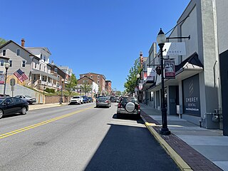
Pennsburg is a borough in Montgomery County, Pennsylvania. Its population was 3,889 at the 2020 census. It is part of the Upper Perkiomen School District. It is also part of the strip of small towns that run together along Route 29: Red Hill, Pennsburg, and East Greenville. The towns are collectively referred to as Upper Perk.

<span class="mw-page-title-main">Perkiomen Township, Pennsylvania</span> Township in the U.S. state of Pennsylvania

Perkiomen Township is a township in Montgomery County, Pennsylvania, United States. As of the 2010 census, the township population was 9,139, which represents a 28.8% increase from the 2000 total of 7,093 residents. Governmentally, it is a township of the second class, governed by a board of supervisors. It is part of the Perkiomen Valley School District. Perkiomen Township includes an abundance of history that goes as far back as to the first tribes who inhabited the area. This township started with the inhabitants of the Lenni-Lenape Tribe and progressed in many ways into what it is today.

<span class="mw-page-title-main">Pottstown, Pennsylvania</span> Borough in Pennsylvania, United States

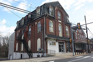
Pottstown is a borough in Montgomery County, Pennsylvania, United States. Pottstown was laid out in 1752–53 and named Pottsgrove in honor of its founder, John Potts. The old name was abandoned at the time of the incorporation as a borough in 1815. In 1888, the limits of the borough were considerably extended. Pottstown is the center of a productive farming and dairying region.

<span class="mw-page-title-main">Royersford, Pennsylvania</span> Borough in Pennsylvania, United States

Royersford is a borough in Montgomery County, Pennsylvania, United States, 32 miles (51 km) northwest of Philadelphia, on the Schuylkill River.

<span class="mw-page-title-main">Schwenksville, Pennsylvania</span> Borough in Pennsylvania, United States

Schwenksville is a borough in Montgomery County, Pennsylvania, United States. The population was 1,431 at the 2020 census. It is notable for being located near the site of the Philadelphia Folk Festival. The borough was founded in 1684, when the Lenni-Lenape Indians ceded to William Penn the land along the Perkiomen Creek; it was incorporated in 1903. The borough was named for George Schwenk, whose son, Jacob Schwenk, served in George Washington's army.

<span class="mw-page-title-main">Skippack, Pennsylvania</span> Census-designated place in Pennsylvania, United States

Skippack, originally named "Van Bebber's Township", is a census-designated place (CDP) in Skippack Township, Montgomery County, Pennsylvania, United States. The population was 3,758 at the 2010 census.

<span class="mw-page-title-main">Skippack Township, Pennsylvania</span> Township in Pennsylvania, United States

Skippack Township is a township in Montgomery County, Pennsylvania, United States. The population was 14,408 in 2022 according to the Census Bureau. This represents a 5.1% increase from the 2010 Census.

<span class="mw-page-title-main">Trappe, Pennsylvania</span> Borough in Pennsylvania, United States

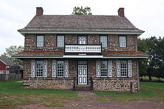
Trappe is a borough in Montgomery County, Pennsylvania, United States. The population was 3,509 at the 2010 census. Augustus Lutheran Church, built in 1743, is the oldest unchanged Lutheran church building in the United States in continuous use by the same congregation. It has been designated a National Historic Landmark.

<span class="mw-page-title-main">Upper Providence Township, Montgomery County, Pennsylvania</span> Township in Pennsylvania, United States

Upper Providence Township is a township in Montgomery County, Pennsylvania, United States. As of the 2010 census, the township population was 21,219.

<span class="mw-page-title-main">Worcester Township, Pennsylvania</span> Township in Pennsylvania, United States

Worcester Township is a township in Montgomery County, Pennsylvania, United States. The population was 9,750 at the 2010 census. It is pronounced as 'WOR-ses-ter.'

The Perkiomen Valley School District (PVSD) is a school district based in central Montgomery County, Pennsylvania (US). It serves the boroughs of Collegeville, Trappe, and Schwenksville, and the townships of Lower Frederick, Perkiomen, and Skippack, in Pennsylvania. The district headquarters are in Perkiomen Township.

<span class="mw-page-title-main">Pennsylvania House of Representatives, District 146</span> American legislative district

The 146th Pennsylvania House of Representatives District is located in Southeastern Pennsylvania and has been represented since 2019 by Joe Ciresi.

The Manor of Gilberts was one of the areas of land that William Penn set aside for himself as the Proprietor of the Province of Pennsylvania. The Manor was located on the along the left (northeastern) bank of the Schuylkill River, extending above and below the Perkiomen Creek. The Manor was created on 8 October 1683 when Penn wrote a warrant assigning the Manor to himself. The tract was named after his paternal grandmother Joanne (Gilbert) Penn's family.

Center Point is an unincorporated community in Worcester Township, Montgomery County, Pennsylvania, United States, at the junction of Routes 73 and 363. It is drained by the Zacharias Creek westward into the Skippack Creek, a tributary of the Perkiomen Creek. The community is served by the Methacton School District and by the Collegeville, Lansdale, and Norristown post offices, with the zip codes of 19426, 19446, and 19403, respectively.

Ridge Pike is a major historic road in the U.S. state of Pennsylvania that opened in 1706 that originally connected Wissahickon Creek to Perkiomen Creek. Inside Philadelphia, it is called Ridge Avenue. Going westward, it traverses many eastern Pennsylvania neighborhoods in Montgomery County including Conshohocken and beyond, connecting with Germantown Pike near Collegeville and continuing to Pottstown. In Montgomery County, Ridge Pike is called Main Street in the Norristown area and again in Collegeville and Trappe, and is called High Street in the Pottstown area.

Germantown Pike is a historic road in Pennsylvania that opened in 1687, running from Philadelphia northwest to Collegeville. The road is particularly notable for the "imposing mansions" that existed in the Germantown neighborhood in Philadelphia. The road was left in ruins after the British destroyed it in the Revolutionary War during the 1777 Battle of Germantown, and was not rebuilt until 1809. Portions of Germantown Pike were signed as U.S. Route 422 (US 422) before the latter was rerouted along a freeway alignment to King of Prussia.

References

  1. Borough of Collegeville - A Brief History Archived July 18, 2011, at the Wayback Machine , accessed April 9, 2011.
  2. "ArcGIS REST Services Directory". United States Census Bureau. Retrieved October 12, 2022.
  3. 1 2 "Census Population API". United States Census Bureau. Retrieved October 12, 2022.
  4. "National Register Information System". National Register of Historic Places . National Park Service. July 9, 2010.
  5. Kostelni, Natalie (May 12, 2009). "Wyeth's Collegeville campus has an uncertain future". Philadelphia Business Journal. Archived from the original on August 21, 2009. Retrieved January 28, 2010.
  6. "Archived copy" (PDF). Archived from the original (PDF) on March 25, 2014. Retrieved March 25, 2014.{{cite web}}: CS1 maint: archived copy as title (link)
  7. "Census of Population and Housing". U.S. Census Bureau. Retrieved December 11, 2013.
  8. 1 2 "U.S. Census website". United States Census Bureau . Retrieved January 31, 2008.
  9. "Incorporated Places and Minor Civil Divisions Datasets: Subcounty Resident Population Estimates: April 1, 2010 to July 1, 2012". Population Estimates. U.S. Census Bureau. Archived from the original on June 11, 2013. Retrieved December 11, 2013.
  10. "Census 2020".
  11. "Montgomery County Election Results". Montgomery County, Pennsylvania. Retrieved January 16, 2017.
  12. "Archived copy". USA Today . Archived from the original on February 15, 2012. Retrieved August 25, 2017.{{cite web}}: CS1 maint: archived copy as title (link)
  13. Zoning Map. Skippack Township, Pennsylvania. Retrieved on September 26, 2018.
  14. "SCI Phoenix." Pennsylvania Department of Corrections. Retrieved on September 26, 2018. "Facility Address: 1200 Mokychic Drive Collegeville, PA 19426"
  15. "About." Perkiomen Valley School District. Retrieved on October 9, 2018.
  16. "Welcome to the Methacton School District website!". Methacton School District . Retrieved April 22, 2020. The District,[...] was created by a 10-year merging of the school districts that had previously served the townships of Lower Providence and Worcester.
  17. "About Spring-Ford". Spring-Ford School District . Retrieved February 9, 2021.
  18. "2012 Catholic grade school consolidations/closings". Catholicphilly.com. July 15, 2012. Retrieved April 22, 2020.
  19. 1 2 "Education Archived 2018-10-09 at the Wayback Machine ." Borough of Collegeville. Retrieved on October 9, 2018.
  20. "Libraries." Borough of Collegeville. Retrieved on October 9, 2018.
  21. "Collegeville Borough map" (PDF). PennDOT. Retrieved March 10, 2023.
  22. Bus 93, SEPTA. Accessed October 10, 2013.
  23. https://sports-reference.com,"Horace Ashenfelter"
  24. wikipedia.com,"Jen Carfagno"
  25. amazon.com "About the author". Accessed November 24, 2008.
  26. https://sports-reference.com, "Michael Matz". Accessed April 1, 2010.
  27. Knickerbocker, Ken (April 14, 2020). "Golfing Legend Riding Out Coronavirus Pandemic at Daughter's Home in Skippack". MONTCO.Today. Retrieved March 4, 2024.
  28. "J.D. Salinger". www.ursinus.edu. Retrieved March 4, 2024.