Zephyrhills South, Florida

Last updated

Zephyrhills South, Florida
CDP
Pasco County Florida Incorporated and Unincorporated areas Zephyrhills South Highlighted.svg
Location in Pasco County and the state of Florida
Coordinates: 28°12′59″N82°11′15″W / 28.21639°N 82.18750°W / 28.21639; -82.18750
Country United States
State Florida
County Pasco
Area
[1]
  Total1.98 sq mi (5.12 km2)
  Land1.98 sq mi (5.12 km2)
  Water0.00 sq mi (0.00 km2)
Population
 (2020)
  Total4,985
  Density2,521.50/sq mi (973.66/km2)
Time zone UTC-5 (Eastern (EST))
  Summer (DST) UTC-4 (EDT)
FIPS code 12-79237 [2]

Zephyrhills South is a census-designated place (CDP) in Pasco County, Florida, United States. The population was 4,435 at the 2000 census.

Contents

Geography

Zephyrhills South is located at 28°12′59″N82°11′15″W / 28.21639°N 82.18750°W / 28.21639; -82.18750 (28.216394, -82.187413). [3]

According to the United States Census Bureau, the CDP has a total area of 1.9 square miles (5.0 km2), all land.

Climate

Climate data for Zephyrhills
MonthJanFebMarAprMayJunJulAugSepOctNovDecYear
Average high °F (°C)71
(22)
73
(23)
77
(25)
82
(28)
87
(31)
90
(32)
90
(32)
91
(33)
88
(31)
83
(28)
76
(24)
72
(22)
82
(28)
Average low °F (°C)52
(11)
53
(12)
56
(13)
62
(17)
67
(19)
71
(22)
73
(23)
73
(23)
72
(22)
66
(19)
58
(14)
53
(12)
63
(17)
Average precipitation inches (mm)2.2
(56)
2.3
(58)
4.5
(110)
3.3
(84)
3.2
(81)
6.7
(170)
8.7
(220)
6.9
(180)
6.5
(170)
3.3
(84)
1.7
(43)
2.1
(53)
51.4
(1,310)
Source: Weatherbase [4]

Demographics

Historical population
CensusPop.Note
1980 1,986
1990 2,51426.6%
2000 4,43576.4%
2010 5,27619.0%
2020 4,985−5.5%
source: [5]

At the 2000 census, [2] there were 4,435 people, 2,199 households and 1,451 families residing in the CDP. The population density was 2,311.9 inhabitants per square mile (892.6/km2). There were 3,651 housing units at an average density of 1,903.2 per square mile (734.8/km2). The racial makeup was 96.05% White, 0.74% African American, 0.36% Native American, 0.36% Asian, 0.02% Pacific Islander, 0.59% from other races, and 1.87% from two or more races. Hispanic or Latino of any race were 2.64% of the population.

There were 2,199 households, of which 11.1% had children under the age of 18 living with them, 58.3% were married couples living together, 5.9% had a female householder with no husband present, and 34.0% were non-families. 28.4% of all households were made up of individuals, and 19.0% had someone living alone who was 65 years of age or older. The average household size was 2.02 and the average family size was 2.39.

11.7% of the population were under the age of 18, 3.9% from 18 to 24, 15.1% from 25 to 44, 22.3% from 45 to 64, and 47.0% who were 65 years of age or older. The median age was 63 years. For every 100 females, there were 93.4 males. For every 100 females age 18 and over, there were 92.2 males.

The median household income was $23,483 and the median family income was $29,681. Males had a median income of $26,771 and females $20,395 for. The per capita income was $14,905. About 8.1% of families and 12.5% of the population were below the poverty line, including 24.9% of those under age 18 and 7.2% of those age 65 or over.

Related Research Articles

<span class="mw-page-title-main">East Whittier, California</span> Place in California, United States

East Whittier is an unincorporated community in Los Angeles County, California, United States. The population was 9,757 at the 2010 census, up from 9,538 at the 2000 census. For statistical purposes, the United States Census Bureau has defined this community as a census-designated place (CDP). The name was changed from East La Mirada in 2012, likely due to its precise location in relation to the city of Whittier. The previous delineation of East Whittier CDP occurred during the 1960 census, when the area recorded a population of 19,884.

<span class="mw-page-title-main">South Whittier, California</span> Census designated place in California, United States

South Whittier is an unincorporated community and census-designated place in Los Angeles County, California just south of the city of Whittier. As of the 2020 census, the CDP had a total population of 56,415, down from 57,156 at the 2010 census.

<span class="mw-page-title-main">Mi-Wuk Village, California</span> Census-designated place in California, United States

Mi-Wuk Village is a census-designated place (CDP) in Tuolumne County, California, United States. The population was 941 at the 2010 census, down from 1,485 at the 2000 census. It was named after the Miwok Indians by the real estate developer and promoter Harry Hoeffler in 1955.

<span class="mw-page-title-main">East Lake-Orient Park, Florida</span> Census-designated place in Florida, United States

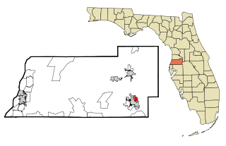
East Lake-Orient Park is an unincorporated census-designated place in Hillsborough County, Florida, United States. The population was 22,753 at the 2010 census, up from 5,703 at the 2000 census following an expansion of its borders. The area is the home of the Florida State Fairgrounds, which hosts the Florida State Fair in mid-February of each year. It was previously home to East Lake Square Mall. The ZIP code for East Lake-Orient Park is 33610 and 33619.

<span class="mw-page-title-main">Thonotosassa, Florida</span> Census-designated place in Florida, United States

Thonotosassa is a census-designated place (CDP) in Hillsborough County, Florida, United States. The population was 15,238 at the 2020 census, up from 13,014 at the 2010 census.

<span class="mw-page-title-main">Crystal Springs, Florida</span> CDP in Florida, United States

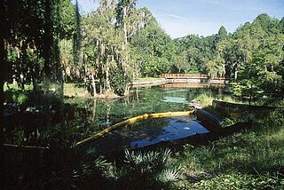
Crystal Springs is a hydrological spring and a census-designated place (CDP) in Pasco County, Florida, United States. The population was 1,175 at the 2000 census.

<span class="mw-page-title-main">Zephyrhills North, Florida</span> CDP in Florida, United States

Zephyrhills North is a census-designated place (CDP) in Pasco County, Florida, United States. The population was 2,544 at the 2000 census.

<span class="mw-page-title-main">Zephyrhills West, Florida</span> CDP in Florida, United States

Zephyrhills West is a census-designated place (CDP) in Pasco County, Florida, United States. The population was 5,242 at the 2000 census.

<span class="mw-page-title-main">Deenwood, Georgia</span> CDP in Georgia, United States

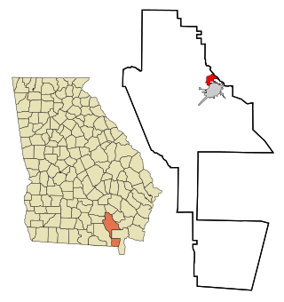
Deenwood is a census-designated place (CDP) in Ware County, Georgia, United States. The population was 1,836 at the 2000 census. It is part of the Waycross Micropolitan Statistical Area. Deenwood Baptist Church is named after this geographical area.

<span class="mw-page-title-main">Sunnyside, Georgia</span> CDP in Georgia, United States

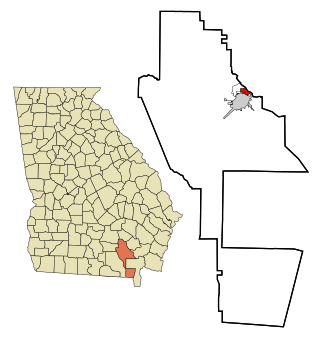
Sunnyside is a census-designated place (CDP) in Ware County, Georgia, United States. The population was 1,385 at the 2000 census. It is part of the Waycross Micropolitan Statistical Area.

<span class="mw-page-title-main">Waikoloa Village, Hawaii</span> Census-designated place in Hawaii, U.S.

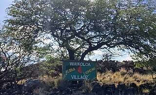
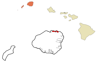
Waikōloa Village is a census-designated place (CDP) in Hawaiʻi County, Hawaii, United States. The population was 6,362 at the 2010 census, up from 4,806 at the 2000 census. The name Waikoloa is used by the local post office.

<span class="mw-page-title-main">Kalihiwai, Hawaii</span> Census-designated place in Hawaii, United States

Kalihiwai is a census-designated place (CDP) in Kauaʻi County, Hawaiʻi, United States. The population was 361 at the 2020 census.

<span class="mw-page-title-main">Greycliff, Montana</span> CDP in Montana, United States

Greycliff is a census-designated place (CDP) in Sweet Grass County, Montana, United States. The population was 56 at the 2000 census.

<span class="mw-page-title-main">Schurz, Nevada</span> CDP in Nevada, United States

Schurz is a census-designated place (CDP) in Mineral County, Nevada, United States. The population was 658 at the 2010 census. It is located on the Walker River Indian Reservation. It is the burial place of Wovoka, the Paiute messiah who originated the Ghost Dance movement.

Tyler Run-Queens Gate was a census-designated place (CDP) in York County, Pennsylvania, United States. The population was 2,926 at the 2000 census. The area was redelineated as two separate CDPs, Tyler Run and Queens Gate, for the 2010 census.

<span class="mw-page-title-main">Inman Mills, South Carolina</span> CDP in South Carolina, United States

Inman Mills is a census-designated place (CDP) in Spartanburg County, South Carolina, United States. The population was 1,050 at the 2010 census.

<span class="mw-page-title-main">Kaylor, South Dakota</span> CDP in South Dakota, United States

Kaylor is a census-designated place (CDP) in Hutchinson County, South Dakota, United States. The population was 30 at the 2020 census.

<span class="mw-page-title-main">Heidelberg, Texas</span> Census-designated place in Texas

Heidelberg is a census-designated place (CDP) in Hidalgo County, Texas. The population was 1,725 at the 2010 United States Census. It is part of the McAllen–Edinburg–Mission Metropolitan Statistical Area.

<span class="mw-page-title-main">Redford, Texas</span> CDP in Texas, United States

Redford is a census-designated place (CDP) in Presidio County, Texas, United States. The population was 90 at the 2010 census.

<span class="mw-page-title-main">Boaz, West Virginia</span> CDP in West Virginia, United States

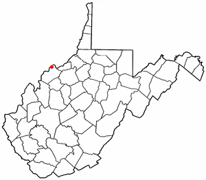
Boaz is a census-designated place (CDP) in Wood County, West Virginia, United States. It is part of the Parkersburg-Marietta-Vienna, WV-OH Metropolitan Statistical Area. As of the 2020 census, the CDP population was 1,321.

References

  1. "2020 U.S. Gazetteer Files". United States Census Bureau. Retrieved December 2, 2021.
  2. 1 2 "U.S. Census website". United States Census Bureau . Retrieved January 31, 2008.
  3. "US Gazetteer files: 2010, 2000, and 1990". United States Census Bureau. February 12, 2011. Retrieved April 23, 2011.
  4. "Weatherbase: Historical Weather for Zephyrhills, Florida". Weatherbase. 2011. Retrieved November 24, 2011.
  5. "CENSUS OF POPULATION AND HOUSING (1790-2000)". U.S. Census Bureau . Retrieved July 18, 2010.