
Hernando County is a county located on the west central coast of the U.S. state of Florida. As of the 2020 census, the population was 194,515. Its county seat is Brooksville, and its largest community is Spring Hill.

Hillsborough County is located in the west-central portion of the U.S. state of Florida. In the 2020 census, the population was 1,459,762, making it the fourth-most populous county in Florida and the most populous county outside the Miami metropolitan area. A 2021 estimate has the population of Hillsborough County at 1,512,070 people with a yearly growth rate of 1.34%, which itself is greater than the populations of 12 states according to their 2019 population estimates. Its county seat and largest city is Tampa. Hillsborough County is part of the Tampa–St. Petersburg–Clearwater Metropolitan Statistical Area.

Pasco County is located on the west central coast of the U.S. state of Florida. According to the 2020 census, the population was 561,691. Its county seat is Dade City, and its largest city is Zephyrhills. The county is named after Samuel Pasco.

Pinellas County is a county located on the west central coast of the U.S. state of Florida. As of the 2020 census, the population was 959,107, which makes it the seventh-most populous county in the state. It is also the most densely populated county in Florida, with 3,491 residents per square mile. The county is part of the Tampa–St. Petersburg–Clearwater, Florida Metropolitan Statistical Area. Clearwater is the county seat. St. Petersburg is the largest city in the county, as well as the largest city in Florida that is not a county seat.

St. Petersburg is a city in Pinellas County, Florida, United States. As of the 2020 census, the population was 258,308, making it the fifth-most populous city in Florida and the second-largest city in the Tampa Bay Area, after Tampa. It is the largest city in the state that is not a county seat. Along with Clearwater, these cities are part of the Tampa–St. Petersburg–Clearwater Metropolitan Statistical Area, the second-largest in Florida with a population of around 2.8 million. St. Petersburg is on the Pinellas peninsula between Tampa Bay and the Gulf of Mexico, and is connected to mainland Florida to the north.
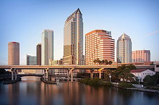
Tampa is a city on the Gulf Coast of the U.S. state of Florida. The city's borders include the north shore of Tampa Bay and the east shore of Old Tampa Bay. Tampa is the largest city in the Tampa Bay area and the seat of Hillsborough County. With an estimated population of 398,173 in 2022, Tampa is the 49th most populous city in the country and the 3rd most populous city in Florida after Jacksonville and Miami.

South Brooksville is a census-designated place (CDP) in Hernando County, Florida, United States. The population was 4,007 at the 2010 census. It is a suburb included in the Tampa-St. Petersburg-Clearwater, Florida Metropolitan Statistical Area.

Spring Hill is a census-designated place (CDP) in Hernando County, Florida, United States. The population was 113,568 at the 2020 census, up from 98,621 at the 2010 census. Spring Hill belongs to Florida's Nature Coast region and is in the Tampa-St. Petersburg-Clearwater metro area. It is east of Hernando Beach, southwest of Brooksville, and north of Tampa.

University is an unincorporated census-designated place in Hillsborough County, Florida, United States. The population was 41,163 at the 2010 census, up from 30,736 at the 2000 census. The University of South Florida is located just southeast of the community, within the Tampa city limits. The community is also known as "University West", mainly due to its location in relation to the university. The community is often notoriously referred to by locals as "Suitcase City" due to the high rate of transients.

Holiday is a census-designated place (CDP) in Pasco County, Florida, United States. It is a suburb of the Tampa-St. Petersburg-Clearwater, Florida Metropolitan Statistical Area. The population was 24,939 as of the 2020 census.

Hudson is a census-designated place (CDP) located at the westernmost end of Pasco County, Florida, United States, and is included in the Tampa-St. Petersburg-Clearwater, Florida Metropolitan Statistical Area. As of the 2010 census, Hudson's population was 12,158.

Land O' Lakes is a census-designated place (CDP) in Pasco County, Florida, United States. Land O' Lakes is part of the Tampa-St. Petersburg-Clearwater, Florida MSA.

Clearwater is a city located in Pinellas County, Florida, United States, west of Tampa and north of St. Petersburg. To the west of Clearwater lies the Gulf of Mexico and to the southeast lies Tampa Bay. As of the 2020 census, the city had a population of 117,292. Clearwater is the county seat of Pinellas County and is the smallest of the three principal cities in the Tampa–St. Petersburg–Clearwater metropolitan area, most commonly referred to as the Tampa Bay Area.
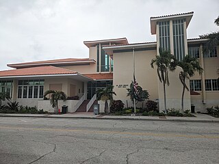
St. Pete Beach is a coastal city in Pinellas County, Florida. Known as a tourist destination, St. Pete Beach was formed from the towns of Pass-a-Grille, Belle Vista, St. Petersburg Beach and unincorporated Pinellas County. The population was 9,346 at the 2010 census.
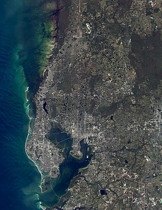
The Tampa Bay area is a major metropolitan area surrounding Tampa Bay on the Gulf Coast of Florida in the United States. It includes the main cities of Tampa, St. Petersburg, and Clearwater. It is the 18th-largest metropolitan area in the United States, with a population of 3,175,275 as of the 2020 U.S. Census.
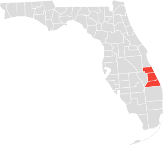
The Treasure Coast is a region in the southeast of the U.S. state of Florida. It borders the Atlantic Ocean and comprises Indian River, Martin, and St. Lucie counties. The region, whose name refers to the Spanish Treasure Fleet that was lost in a 1715 hurricane, evidently emerged from residents' desire to distinguish themselves from the Gold Coast to the south.
East Tampa is an unincorporated community in Hillsborough County, Florida, United States. It is partially within the census-designated place (CDP) of Gibsonton. The ZIP code for East Tampa is 33619.

The Sarasota metropolitan area is a metropolitan area located in Southwest Florida. The metropolitan area is defined by the Office of Management and Budget as the North Port–Sarasota–Bradenton metropolitan statistical area as a metropolitan statistical area (MSA) consisting of Manatee County and Sarasota County. The largest cities in the MSA are North Port, Sarasota, and Bradenton. At the 2020 census, the MSA had a population of 833,716. The Census Bureau estimates that its population was 891,411 in 2022.

A Nicaraguan American is an American of Nicaraguan descent. They are also referred to as "nica" or "nicoya".

Meadow Oaks is an unincorporated community and census-designated place (CDP) in Pasco County, Florida, United States. Located north of Florida State Road 52 inland from Hudson, it is within the Tampa–St. Petersburg–Clearwater Metropolitan Statistical Area (MSA) and the Southwest Florida Water Management District.


