Zvimba District

Last updated

Zvimba District
Mashonaland West districts.png
Zvimba District (light green) in Mashonaland West Province
Coordinates: 17°42′S30°12′E / 17.700°S 30.200°E / -17.700; 30.200
Country Zimbabwe
Province Mashonaland West
Area
  Total6,072 km2 (2,344 sq mi)
Population
 (2022 census)
  Total348,002
  Density57/km2 (150/sq mi)

Zvimba District is a district of Mashonaland West Province, Zimbabwe. [1]

Contents

Location

The district is located in Mashonaland West Province, in central northern Zimbabwe. Zvimba District is bordered by Guruve District to the north, Mazowe District to the east, the city of Harare to the southeast, Chegutu District to the south, Kadoma District to the southwest and Makonde District to the west and northwest.

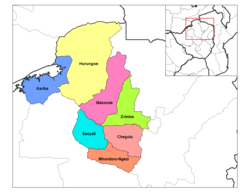
Its main town, Murombedzi, is located about 110 kilometres (68 mi) by road west of Harare, the capital and largest city of Zimbabwe. The district lies about 48 kilometres (30 mi) by road, south of the town of Chinhoyi, Makonde District, the nearest large town. [2]

History of Chief Zvimba mtorashanga

The Zvimba chieftainship was founded by Neuteve Chihobvu who migrated from Guru Uswa. When he arrived in the area now known as Zvimba he complained that his feet were swollen, (Nda zvimba makumbo). He was thereafter called Zvimba. The land now called Zvimba then belonged to the Rozvi tribe then headed by Tambare. Tambare allocated the land to Neuteve (Zvimba). Neuteve became the first chief Zvimba.

Overview

Zvimba District is primarily a farming and ranching district. Crops raised include tobacco, maize and cotton. Cattle are raised for dairy products and beef.

Education

A fair number of primary and secondary schools are located in Zvimba District, the most well-known being a private, selective school called Cornway College in Mt. Hampden on the outskirts of Zvimba and in very close proximity to Harare. Kutama College previously known as (St Francis Xavier College) is an all-boys high school located near the town of Norton in the Zvimba area, 80 kilometres southwest of the Zimbabwean capital Harare.

Population

The current population of Zvimba District is 263 020 according to the last census of 2012. Of this population 50. 2 per cent are male while females constitute the remaining 49.8 per cent. By population size, Zvimba Rural District is the second largest in Mashonaland West after Hurungwe and has 17.5 per cent of the total provincial population. [3] The 2017 ZimStats population projections state that by 2020 Zvimba will have around 161 660 males and 155 931 females respectively. [4]

Notable people

See also

Related Research Articles

<span class="mw-page-title-main">Manicaland Province</span> Province in Zimbabwe

Manicaland is a province in eastern Zimbabwe. After Harare Province, it is the country's second-most populous province, with a population of 2.037 million, as of the 2022 census. After Harare and Bulawayo provinces, Manicaland is Zimbabwe's third-most densely populated province. Manicaland was one of five original provinces established in Southern Rhodesia in the early colonial period. The province endowed with country's major tourist attractions, the likes of Mutarazi Falls, Nyanga National Park and Zimbabwe's top three highest peaks. The province is divided into ten administrative subdivisions of seven rural districts and three towns/councils, including the provincial capital, Mutare. The name Manicaland is derived from one of the province's largest ethnic groups, the Manyika, who originate from the area north of the Manicaland province and as well as western Mozambique, who speak a distinct language called ChiManyika in Shona.

<span class="mw-page-title-main">Mashonaland West Province</span> Province in Zimbabwe

Mashonaland West is a province of Zimbabwe. It has an area of 57,441 km² and a population of approximately 1.9 million (2022). Chinhoyi is the capital of the province.

<span class="mw-page-title-main">Chinhoyi Caves</span> Group of caves in north central Zimbabwe

The Chinhoyi Caves are a group of limestone and dolomite caves in north central Zimbabwe. Designated a National Park in 1955, and managed by the Zimbabwe Parks & Wildlife Management Authority.

Chegutu, originally known as Hartley, is a town in Mashonaland West Province, Zimbabwe.

Alaska is a small town in central northern Zimbabwe in Makonde District, Mashonaland West Province.

Banket is a town in the province of Mashonaland West, Zimbabwe. It is located about 95 km north-west of Harare on the main Harare-Chinhoyi road. According to the 1982 Population Census, the town had a population of 5,698. The name of the town is derived from banket rock formation: early settlers saw a conglomerate, which they hoped would bear gold, like the banket of the Witwatersrand gold fields. The conglomerate was not gold-bearing, although gold was late discovered and, along with chromite, is still mined in the area. Cattle, maize, cotton and tobacco are commercially farmed in the area.

Raffingora is a small town in the province of Mashonaland West, Zimbabwe. It is located about 45 km north-east of Chinhoyi in one of Zimbabwe's leading tobacco growing districts. The town was heavy with agricultural activities before the land reform program. A lot of farms are not producing due to poor agricultural and political practices. The town further suffered from the expropriation of white-owned commercial farms in the controversial land reform programme that began in 2000. The town's main source of income and business clientele, the farmers and businesspeople, all but disappeared from the scene, leading to a loss of business and income. The settlers who took over the farms failed to fill the gap created by the demise of commercial farms. This led to the collapse of retail businesses and the few industries that were in the town.

Lion's Den is a small town in Zimbabwe.

Karoi is a town in Zimbabwe.

Chinhoyi, previously known as Sinoia during the colonial era, is a city in central northern Zimbabwe in the Makonde District. It has a population of 90,800 and is primarily a college town, although it was originally founded as an Italian group settlement scheme. The nearby Chinhoyi Caves and national park are a popular attraction.

<span class="mw-page-title-main">Mwami, Zimbabwe</span> Settlement in Zimbabwe

Mwami is a settlement in the province of Mashonaland West, Zimbabwe.

<span class="mw-page-title-main">Outline of Zimbabwe</span> Overview of and topical guide to Zimbabwe

The following outline is provided as an overview of and topical guide to Zimbabwe:

Murombedzi is a town in Zimbabwe.

Sabina Gabriel Mugabe was a Zimbabwean politician. She was the younger sister of the former Zimbabwean president Robert Mugabe.

<span class="mw-page-title-main">Chegutu District</span> Place in Mashonaland West, Zimbabwe

Chegutu, originally known as Hartley, is a district of Mashonaland West Province, Zimbabwe. The district headquarters is located in Chegutu, a city which lies of the Harare-Bulawayo Road,.

<span class="mw-page-title-main">Makonde District</span> District in Zimbabwe

Makonde District is a district in Zimbabwe.

Moleli High School, is a co-education high school located in Mashonaland West Province, Makwiro, Chegutu District, Msengezi area near the town of Norton in the Zvimba area, 80 kilometres southwest of the Zimbabwean capital Harare. It offers O' and A' levels in boarding facilities. It was established in 1962 by Ronald E. Sellers of the Methodist Church in Zimbabwe and named after the late Methodist Rev. Modumedi Moleli and is a Methodist mission school. Moleli has a student population of about 620 pupils, and is considered one of Zimbabwe's top performing high schools. It is a sister school to Sandringham High School which they share sibling rivalry.

The A5 Highway is a national road in Zimbabwe. It joins the cities of Harare and Bulawayo, and is hence known as the Harare-Bulawayo Highway. It is one of the two routes that form the R2 Route, which connects Harare with the Plumtree Border with Botswana.

Glen View is a high-density suburb that lies on the border of Harare Province and Mashonaland West. It split between the two provinces, with the larger part on Harare’s side and the remainder on Mashonaland West side under their governance of Zvimba Rural District. It is believed to have 160,000(6.4% of Harare’s population) people although the Zimstat says it has on 45,000 people. It shares boundaries with Budiriro on the North (4.341km), Glen Norah on the East(4.0km), South and West being Mashonaland West. It is divided into 8 parts namely Glen View 1, 2, 3, 4, 7, 8, 1 Extension and Riverside. It has around 15000 residential stands which ranges from 200sqm to 500sqm with most of them averaging 10 people per house.

References

  1. "Zvimba (District, Zimbabwe) - Population Statistics, Charts, Map and Location". www.citypopulation.de. Retrieved 17 February 2024.
  2. "Road Distance Between Murombedzi And Chinhoyi With Map". Distancecalculator.himmera.com. Retrieved 9 March 2022.
  3. "Census 2012 : Mashonaland West Province Report" (PDF). Zimstat.co.zw. Retrieved 9 March 2022.
  4. "INTER-CENSAL DEMOGRAPHIC SURVEY, 2017" (PDF). Zimstat.co.zw. Retrieved 9 March 2022.

17°42′0″S30°12′0″E / 17.70000°S 30.20000°E / -17.70000; 30.20000