Related Research Articles
Land reform in Zimbabwe officially began in 1980 with the signing of the Lancaster House Agreement, to reverse the distribution of land that resulted from the colonial occupation of the country by white people. The colonial distribution that started in 1884, took land from black people, land the black people called home and used for habitation and production as subsistence farmers. The colonisers drove black people to dry and unproductive land while they shared prime and productive land amongst themselves resulting in a population of 3% owning 51% of the land while 4.3 million black people owned 42%, with the remainder being land for towns and other non-farming activities. The white people enjoyed superior political and economic status, but this was resisted, leading to war, and political independence in 1980. At independence, the Lancaster House Agreement was signed and it had a clause that prohibitted return of land, except where a white person had surrendered or offered it for sale. This did not return enough land until the accelerated land reform programme started in 2000. The programme altered the racial imbalance of land ownership.
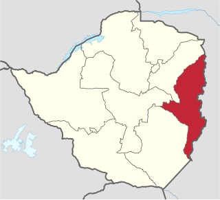
Manicaland is a province in eastern Zimbabwe. After Harare Province, it is the country's second-most populous province, with a population of 2.037 million, as of the 2022 census. After Harare and Bulawayo provinces, Manicaland is Zimbabwe's third-most densely populated province. Manicaland was one of five original provinces established in Southern Rhodesia in the early colonial period. The province endowed with country's major tourist attractions, the likes of Mutarazi Falls, Nyanga National Park and Zimbabwe's top three highest peaks. The province is divided into ten administrative subdivisions of seven rural districts and three towns/councils, including the provincial capital, Mutare. The name Manicaland is derived from one of the province's largest ethnic groups, the Manyika, who originate from the area north of the Manicaland province and as well as western Mozambique, who speak a distinct language called ChiManyika in Shona.
Chegutu, originally known as Hartley, is a town in Mashonaland West Province, Zimbabwe.
Goromonzi District is a district of Mashonaland East Province, Zimbabwe, in Southern Africa. It is located in the eastern part of Zimbabwe, and covers an area of approximately 9,100 square kilometres (3,500 sq mi). As of the 2022 census, it had a population of 386,203, up from 154,262 in the 2002 census. The people who live in the region are principally from the Shona tribe.
Wedza is a district in the province of Mashonaland East, Zimbabwe. It is located about 50 kilometres (31 mi) south of Marondera, and 127 kilometres (79 mi) south of Harare. The area was sparsely inhabited by the Mbire people of the Soko Clan as early inhabitants who mined iron in the Hwedza hills during the 9th-12th centuries which means "a place of wealth". A village of Wedza was established in 1910 by Colonial administration. Gold, beryl, nickel, tungsten and grayite were mined in the hills around the village but deposits were too small to make further commercial mining viable.
Macheke is a small Zimbabwean town located in Murewa District, province of Mashonaland East, located about 105 km south-east of Harare on the main A3 Harare-Mutare highway road. According to the 1982 population census, the town had a population of 1,888. It was named after the Macheke River and means "you have divided". Macheke is also the hometown of Wicknell Chivayo, a well known and controversial Zimbabwean businessman accused of government contract abuse during the rule of Robert Mugabe.
Norton is a commuter town in the province of Mashonaland West, Zimbabwe near Harare. It is located about 40 km west of Harare on the main road and railway line connecting Harare and Bulawayo.
The following lists events that happened during 2000 in Zimbabwe.
The Mazowe Dam is a dam on the Mazowe River in Zimbabwe, in the Iron Mask Hills about 35 kilometres (22 mi) north of Harare. Constructed in 1920, it was built mainly to provide irrigation for the Mazoe citrus estates. The dam was also home to the Hunyani Rowing Club and formerly provided facilities for St. Georges, Prince Edward, Arundel and other rowing clubs. It is the only major dam on the Mazowe River.
Centenary is a village in Mashonaland Central province in Zimbabwe. On June 21, 2001, Centenary was a pilgrimage for those who wanted to see the total solar eclipse, as it was one of the few areas of Zimbabwe that witnessed it.

Mazowe Boys High School in Harare, Zimbabwe is a Salvation Army boarding school established in 1959. The school teaches Christian values in accordance with Salvation Army principles.

The Mazowe River is a river in Zimbabwe and Mozambique.

Borrowdale is a residential suburb in the north of Harare, Zimbabwe, which ranks among the most affluent and prestigious residential areas in the country. It forms part of the Northeast suburbs of the city of Harare, with a population of 28,929 as of the Zimbabwe 2022 Census.

Agriculture plays a crucial role in the lives of Zimbabweans in rural and urban areas. Most of the people in rural areas survive on agriculture and they need support for them to get good yields.
Chitomborwizi is a farming area in Mashonaland West in Zimbabwe formerly known as Chitomborwizi African Purchase Area. The farms are small to medium sizes. Areas like these were created for black farmers during the colonial era, similar areas are Musengezi near Chegutu, Mushagashe near Chatsworth, Zimbabwe, Wilshere in Chivhu, Matepatepa in Mt Darwin to mention just a few.

Farming systems in India are strategically utilized, according to the locations where they are most suitable. The farming systems that significantly contribute to the agriculture of India are subsistence farming, organic farming, industrial farming. Regions throughout India differ in types of farming they use; some are based on horticulture, ley farming, agroforestry, and many more. Due to India's geographical location, certain parts experience different climates, thus affecting each region's agricultural productivity differently. India is very dependent on its monsoon cycle for large crop yields. India's agriculture has an extensive background which goes back to at least 9 thousand years. In India, in the alluvial plains of the Indus River in Pakistan, the old cities of Mohenjo-Daro and Harappa experienced an apparent establishment of an organized farming urban culture. That society, known as the Harappan or Indus civilization, flourished until shortly after 4000 BP; it was much more comprehensive than those of Egypt or Babylonia and appeared earlier than analogous societies in northern China. Currently, the country holds the second position in agricultural production in the world. In 2007, agriculture and other industries made up more than 16% of India's GDP. Despite the steady decline in agriculture's contribution to the country's GDP, agriculture is the biggest industry in the country and plays a key role in the socio-economic growth of the country. India is the second-largest producer of wheat, rice, cotton, sugarcane, silk, groundnuts, and dozens more. It is also the second biggest harvester of vegetables and fruit, representing 8.6% and 10.9% of overall production, respectively. The major fruits produced by India are mangoes, papayas, sapota, and bananas. India also has the biggest number of livestock in the world, holding 281 million. In 2008, the country housed the second largest number of cattle in the world with 175 million.
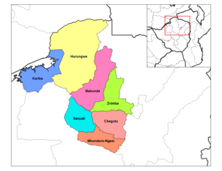
Zvimba District is a district of Mashonaland West Province, Zimbabwe.
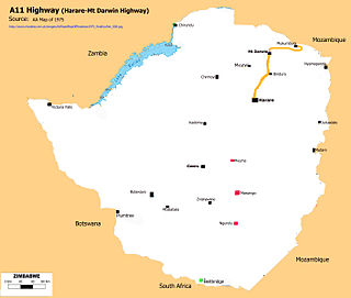
A11 Highway is a national road in Zimbabwe, running from Harare to Bindura through to Mount Darwin. It is also known as the P1 Road, Zimbabwe primary road number 1.
Christopher Tichaona Kuruneri was a Zimbabwean businessman, politician, lawyer, farmer and philanthropist. He was a Minister of Finance, Deputy Minister of Finance and Economic Development and member of parliament for Mount Darwin East. Kuruneri was a member of Zanu-PF. He owned Ascotvale farm in the Mazowe valley in Zimbabwe.
References
- ↑ "Mazowe District". GeoNameId : 886383. geonames.org. Retrieved 15 June 2009.
- ↑ 1:250,0000 Series: Harare (Map) (1998 ed.). Surveyor General, Zimbabwe.
| | This Zimbabwe location article is a stub. You can help Wikipedia by expanding it. |