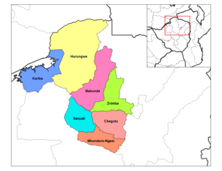
Buhera District is a district in Manicaland Province, in eastern Zimbabwe.
Bindura is a town in the province of Mashonaland Central province, Zimbabwe. It is located in the Mazowe Valley about 88 km north-east of Harare. According to the 1982 Population Census, the town had a population of 18,243. This rose to 21,167 in the 1992 census and in the 2012 census it had reached 46,275. It is the administrative capital of the province. Bindura Nickel, now called Trojan Nickel Mine, a subsidiary of Mwana Africa plc, mines nickel, copper and cobalt in the area and operates a smelter refinery just south of the town. Cotton and maize are grown intensely in the region. The first basic school in Bindura opened in 1912.
Wedza is a district in the province of Mashonaland East, Zimbabwe. It is located about 50 kilometres (31 mi) south of Marondera, and 127 kilometres (79 mi) south of Harare. The area was sparsely inhabited by the Mbire people of the Soko Clan as early inhabitants who mined iron in the Hwedza hills during the 9th-12th centuries which means "a place of wealth". A village of Wedza was established in 1910 by Colonial administration. Gold, beryl, nickel, tungsten and grayite were mined in the hills around the village but deposits were too small to make further commercial mining viable.
Sanyati is a town in Zimbabwe.

The Republic of Zimbabwe is broken down into 10 administrative provinces, which are divided into 64 districts and 1,970 wards.
Zhombe, originally known as Jombe, is a rural communal area in Kwekwe District, Midlands Province, Zimbabwe. It is an area of mixed Shona and Northern Ndebele People. It lies along the Mnyathi border line between Midlands and Mashonaland Provinces. There are a few commercial farms within its borders and a handful of resettlement areas. Most of it is within the Zhombe Constituency. Its administrative centre is the Zhombe Joel Growth Point, and it is under the Zibagwe Rural District Council.
Gokwe Centre is a rural town in the Midlands province in Zimbabwe. The town is usually referred to as "Gokwe Centre" because the larger region is called Gokwe.

Lupane ( luːpɑːnɛ) District is located in the Matabeleland North Province of Zimbabwe, and it is also the Provincial Capital. The District is situated at an elevation of 976 m with a population of 107,000 inhabitants by 2022. Lupane Town is the main center of the district located 172 km from Bulawayo along the A8 Victoria Falls Road. The Government Provincial Administrative offices are located at the Town Centre. A new university near the Town has been established under the name Lupane State University, which caters for the region and beyond. The word Lupane is thought to be a Kalanga or Lozwi word.

Mutorashanga is a small ferrochrome mining town in Mashonaland West province in Zimbabwe. Situated on Zimbabwe's Great Dyke mountain range, about 100 kilometers north of the capital, Harare. The mines at Mutorashanga are largely owned by Zimasco, a chrome mining company owned in turn by Sinosteel Corporation, although some are operated by contractors. The area is well known for its abundant aloes, now threatened by mining, and other endemic flora. Aloe Ortholopha is endemic to the section of the Great Dyke mountain range in the Mutorashanga area.

Gokwe South District is one of the eight administrative districts of the Midlands Province of Zimbabwe. The district administrative seat is located in Gokwe Town also known as Gokwe Centre and the District Administrator is the focal person in terms of all district administrative matters. The district is divided into two administrative entities under the Ministry of Local Government, Public Works and National Housing, which are Gokwe South Rural District Council and Gokwe Town Council. The two district administrative entities were legally setup under the Urban Councils Act of 2015 [Chapter 29:15] and Rural District Councils Act [Chapter 29:13] under the constitution of Zimbabwe. The district is further subdivided into 01 senatorial constituency, 05 parliamentary constituencies and 33 council wards. These constituencies and wards are shared between these two administrative entities of Gokwe South District. According to the 2012 ZIMSTAT National Census Statistics the population of the district was at 330 036 people. Gokwe district is in the north-western part of Zimbabwe its average temperature vacillates at 40 degrees Celsius. Gokwe South District shares its boundaries with 06 districts, namely Binga District, Nkayi District, Kwekwe District, Kadoma District, Lupane District and Gokwe North District.

Zvimba District is a district of Mashonaland West Province, Zimbabwe.

Makonde District is a district in Zimbabwe.

Columbina Rural Service Center is a populated place in Zhombe. It is 95 km northwest of Kwekwe and 67 km southwest of Kadoma.

Ngondoma River is a river in Zhombe Communal Land, Kwekwe District in the Midlands province of Zimbabwe.

Gokwe North Rural District Councils is a local government organ administering Gokwe North District. There are eight Rural District Councils in the Midlands Province of Zimbabwe all established in terms of the Zimbabwe Rural District Councils Act; Chapter 29.13.

Tongogara Rural District Council is a local government organ administering Shurugwi District Rural District. There are two local government arms, Shurugwi Town Council created under the Zimbabwe Urban Councils Act, Chapter 29.15 administering Shurugwi, and Tongogara RDC created in terms of the Zimbabwe Rural District Councils Act, Chapter 29.13 overseeing the rural Shurugwi South District

Mutange Dam, across Mutange River, is a manmade earth fill embarkment dam located in Chisina Village, 30 km east of Gokwe and 35 km northwest of Empress Mine, in the Midlands Province of Zimbabwe. Mutange Dam is 42 km by road from Gokwe and 49 km from Empress, 117 km from Kadoma and 146 km from Kwekwe via Empress. It is owned and operated by the Ministry of Water Resources and Development.


