1951 British Mount Everest reconnaissance expedition

Last updated

The 1951 British Mount Everest reconnaissance expedition ran between 27 August 1951 and 21 November 1951 with Eric Shipton as leader.

Contents

The expedition reconnoitred various possible routes for climbing Mount Everest from Nepal concluding that the one via the Khumbu Icefall, Western Cwm and South Col was the only feasible choice. This route was then used by the Swiss in their two expeditions in 1952 followed by the successful ascent by the British in 1953.

Background

After World War II, with Tibet closing its borders and Nepal becoming considerably more open, the reconnaissance of Mount Everest from Nepal had become possible for the first time.

In 1950 a highly informal trek involving Charlie Houston and Bill Tilman reached what was to become Everest Base Camp on the Khumbu Glacier. Although their report about whether the summit could be reached from there was not very encouraging, they thought an attempt might nonetheless be viable. [1]

Topographical knowledge in 1951

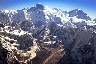
By 1951 the location of the South Col was well known – it had been seen from the east in Tibet and photographed from the air – but it had never been possible to view its western side. There remained three main aspects of a route to Everest via the Western Cwm where the difficulties were unknown: the Khumbu Icefall, the climb up to the South Col, and the ascent to the final ridge.

The best evidence about the Icefall was from Tilman and Houston, who were the only people to have seen it close up and who considered it difficult but achievable. The Western Cwm had been glimpsed several times, but it was not clear whether its floor was relatively flat or if it sloped up towards the head of the glacier below the South Col. A pronounced slope might make ascending the valley more awkward but it would reduce the height to be climbed at the head of the valley. Regarding the final ridge, the pair had seen a very steep ridge, quite possibly unclimbable, but they realized that appearances might have been deceptive [note 1] : the ridge observed might have been blocking the view of a true ridge from the South Col to the summit. The 1921 reconnaissance had ascended the Kama valley east of Everest to approach the Kangshung Face. Observing the South Col from that side, they had seen a seemingly easier ridge linking it to the summit. [3] [4]

In early 1951, Everest enthusiast Michael Ward was carefully studying relevant photographs and maps (the Milne-Hink map) in the Royal Geographical Society archives when he happened to find some photographs taken clandestinely by the RAF in 1945. One of these showed the north face of Lhotse and part of the terrain between the head of the Western Cwm and the South Col. Another showed a broad, snow-covered ridge (the Southeast ridge) stretching from the summit down to the South Col, and a clearly separate steeper ridge falling from near the summit down into the Western Cwm. [3] [5]

Expedition preparations

On the basis of this photographic evidence, Ward proposed to the Himalayan Committee that a reconnaissance expedition make direct inspections from the ground. Despite support from Bill Murray and Campbell Secord, the committee was reluctant to ask for approval from Nepal and were surprised when permission was granted; Ward believed the committee had hoped it would be refused. [6] [7] Murray was to be leader, with Ward, Secord, Tom Bourdillon, and Alfred Tissierès forming the initial party but when Eric Shipton turned up (after having been expelled from his post as British consul in Kunming, China) he was persuaded to take on the leadership. Shipton's prestige helped gain sponsorship from The Times .

Trekking route from railhead at Jogbani to Khumbu Glacier Trek routes to Everest, 1951.svg
Trekking route from railhead at Jogbani to Khumbu Glacier

Shipton himself, discouraged by Tilman's discoveries, was not hopeful of finding a route – he rated the chances as 30 to one – but he was very keen to visit Solu Khumbu, the home of his pre-war Sherpa friends. Secord (from Canada) and Tissierès (from Switzerland) had to withdraw. Keen to keep the party small, Shipton rejected various distinguished applicants, resulting in a party which now comprised only Shipton plus Tom Bourdillon, Bill Murray and Michael Ward.

Only after leaving for Delhi he agreed to accept two additional climbers – self-selected from the four New Zealand climbers who were just completing an expedition in Garhwal Himalaya [note 2] It was Earle Riddiford and Ed Hillary [note 3] who hurried to meet the rest of the team. With Ang Tharkay as sirdar and twelve Sherpas, the main party departed Jogbani on 27 August 1951; the New Zealanders caught up with them on 8 September at Dingla. [6] [8] [9]

Hillary was nervous about meeting Shipton, the most famous living Himalayan mountaineer, and was worried his own colonial upbringing might not be up to the standards expected by the English. He wrote later "As we came into the room, four figures rose to meet us. My first feeling was one of relief. I had rarely seen a more disreputable bunch, and my visions of changing for dinner faded away for ever". [10]

Expedition

Khumbu Glacier and Icefall

The party took the same route as Houston and Tilman except for a minor detour at Dingla to avoid a bridge that had been swept away. After a month-long trek in the late monsoon they reached Namche Bazaar, and on 30 September Shipton and Hillary climbed sufficiently far up Pumori that they had the first good view up the Western Cwm. [note 4] The Cwm sloped to a height of about 23,000 feet (7,000 m), which was 2,000 feet (610 m) higher than expected, so that a climb up the Lhotse glacier to about 25,000 feet (7,600 m) would lead to a traverse to the South Col. This was all encouraging but the Icefall looked to be a problem. All the same, Hillary was already able to look forward to a summit attempt in 1952. [12] [13]

Meanwhile, Riddiford and Sherpa Pasang had found a way through most of the lower icefall, but on 4 October Shipton, Hillary, Riddiford and Bourdillon with three Sherpas had reached 30 feet (9 m) below the crest of the icefall when a relatively minor avalanche decided Shipton to turn back. He was unwilling to risk the lives of the inexperienced Sherpas who could not make an informed decision about the considerable unavoidable risks. From Shipton's point of view they had determined that a possible route had been found, it could not be attempted in the conditions of deep snow then prevailing, and he wanted to see if there were alternative routes to the top from the east or west. [14]

Exploration of Everest's southern foothills

Routes reconnoitred near Everest Routes near Mount Everest, 1951.svg
Routes reconnoitred near Everest

Ward, Bourdillon, Riddiford and Murray started a three-week trek by heading west from the Khumbu valley, trying to find the Chola Khola. At the head of this valley they had been told (wrongly) that there was a pass into Tibet, presumably to the West Rongbuk Glacier. However, their map was inaccurate, and they had in fact reached the Ngojumba glacier, the main source of the Dudh Khosi river, at the foot of Cho Oyu. They went north along Cho Oyu's east face but could see no route towards its summit. They then headed for Nup La [note 5] but progress was slowed by two considerable icefalls so they abandoned the attempt and travelled back to Namche Bazaar improving the mapping of the Chola Khola region as they went. [15]

Meanwhile, Shipton and Hillary descended the Khumbu and then travelled east up the Imja glacier which is south of the Lhotse–Nuptse wall. They hoped to find a pass over to the Barun glacier and thence a further pass west of Pethangse. [note 6] However, they found no crossing to the Barun and so headed south down the Hongu glacier until eventually reaching the Barun. Since they were too far south to reach Pethangtse in the time available, they returned to Khumbu by crossing the south ridge of Ama Dablam. [16]

The entire party met up again and made another attempt to climb the Khumbu Icefall, but found there had been a major collapse of ice and the area was highly unstable. A few days later, on 28 October, conditions had improved and they reached the top of the icefall only to encounter a 100-yard (90 m) crevasse splitting the glacier from side to side and separating it from the almost horizontally-flowing glacier in the Western Cwm itself. They retreated after forming the opinion that ice conditions might be more stable for a springtime expedition, after the consolidation of the winter snows. On 30 October they were back at Namche Bazaar. [17]

Kathmandu via the Gaurishankar range

The party was to return home via Kathmandu to the west so they traversed the completely unexplored region between the Bhote Koshi river of Sola Khumbu and the Rongshar valley in Tibet. They crossed a new pass, naming it the Menlung La, and one side expedition reached the Nangpa La (which had been incorrectly positioned on their map) and spotted two possible routes up the northwest face of Cho Oyu. Another group discovered and named Menlungtse. They discovered and photographed some animal tracks that they could not identify, but which the Sherpas said were of a yeti. Passing north of Gaurishankar they headed southwest and then west to reach Kathmandu on 21 November. [18]

Aftermath

Preparations for 1953 expedition

Even while they were still investigating the Khumbu Icefall, Shipton reported back to the Himalayan Committee that they had found "a practicable route from the West Cwm to the summit of Mount Everest". They intended to mount an expedition for 1952 to make an attempt on the summit. However, already in May 1951 Nepal had accepted a Swiss application to attempt Everest. Shipton went to Zurich to tell the Swiss of his findings and there were discussions about various ideas for a combined Swiss–British team but nothing came of the proposals. Instead, Nepal gave permission for the British Cho Oyu expedition in 1952 followed by Everest in 1953. [19] In the longer term, all this favoured the British aspirations for Everest – the British would not have been ready in 1952 and the Swiss were to reciprocate the help Shipton had given them with practical advice about the mountain. [20]

The 1952 Swiss Mount Everest expedition very nearly reached the summit, so the minds of the British mountaineering community and establishment became strongly focused on their 1953 slot, particularly because France had been granted an opportunity for 1954. [21] Shipton had become well known and popular with the public and he was the obvious leader with a long and distinguished track record in Himalaya. [22] He did, however, have broader perspectives than Everest and after Cho Oyu he did not return home but continued trekking with Hillary. Back in London things were stirring. Some climbers, including some of those on the Cho Oyu expedition, approached the Himalayan Committee about Shipton's perceived lack of drive and single-minded commitment plus poor planning and leadership in 1952 and the Committee did not disagree. [23]

The most likely alternative leader was John Hunt, a colonel in the army who had been a member of the Alpine Club since 1935 and had mountaineering experience in the Karakoram and the Alps. He had climbed to 24,500 feet (7,500 m) and was only turned down for the 1936 British Mount Everest expedition because of an adverse (and incorrect) medical report about a heart murmur. [note 7] [25] During the war he had been an instructor for the Commando Mountain and Snow Warfare school in Scotland. He was well known for his organisational abilities and he was friendly with several members of the Himalayan Committee, [23] having been climbing in the Alps with the secretary Basil Goodfellow. Another option was Charles Wylie, a climber who spoke Nepalese fluently; he became the organising secretary. Hunt and Wylie were in the Army, so were experienced in logistics (and might be available immediately and free of charge). [26]

When Shipton returned home and was called to a meeting of the Himalayan Committee on 28 July 1952, he still did not know his leadership had been called into question. His main opponents were not present and no one liked to tell him what had been happening. Shipton, indeed, expressed his own doubts about his leadership – he preferred small, exploratory, trekking-style expeditions and disliked a competitive element. Nonetheless, the committee said he was their choice as leader and supported his proposal for Charles Evans to be co-leader. Behind the scenes Hunt was offered the co-leadership, and when the two men met and discovered they had been told different stories, they were both dismayed. Hunt thought his chance at Everest had gone. At the next meeting of the committee, it was Shipton's allies who were not there and Shipton was asked to leave the room while the leadership was discussed. When he returned he was told his involvement could only be as co-leader and even that would have to be surrendered once Base Camp had been reached. He was told a man of "dynamic personality, drive and enthusiasm" was required. The Committee went on to send a telegram to Hunt appointing him as leader without waiting for Shipton to reply. Shipton decided he would not take part in the expedition. [27]

There was an outcry amongst active mountaineers. Bourdillon resigned his appointment to the 1953 expedition but was persuaded by Shipton to reconsider. Hillary sent a telegram "Consider change most unwise. New Zealand climbers owe you considerable debt of gratitude", although he privately criticized Shipton's leadership in his diary. [28] Murray, however, whilst deploring the committee's methods, privately thought Hunt would be the better leader. Hunt returned to London in October and started with the preparations for the 1953 British Mount Everest expedition. [29] [30]

Notes

  1. What they were looking at is now known as the South Pillar (or South Buttress) and it was first climbed in 1980. It descends steeply in a southwest direction from Everest's South Summit to the floor of the Western Cwm. The Southeast ridge goes from the true summit to the South Col and has a more moderate slope. [2]
  2. Shipton had met Dan Bryant on the 1935 British Mount Everest reconnaissance expedition and had formed a positive view of New Zealand climbers.
  3. The other two climbers were Edmund Cotter and George Lowe; Lowe had wanted to go instead of Riddiford, but could not pay his share of the costs.
  4. They had ascended 2,000 feet (610 m) higher than Tilman and Houston. [11]
  5. Nup La is a col that had been reached from Tibet during the 1924 British Mount Everest expedition but it had not been crossed. It was first crossed by Hillary and George Lowe during the 1952 Cho Oyu expedition;.
  6. Pethangtse lies on the ridge between Lhotse and Makalu. A pass east of Pethangtse had been reached from the Kama valley by the 1921 British Mount Everest reconnaissance expedition.
  7. The report had gone on to warn him to be careful climbing stairs. [24]

Related Research Articles

<span class="mw-page-title-main">Mount Everest</span> Earths highest mountain

Mount Everest is Earth's highest mountain above sea level, located in the Mahalangur Himal sub-range of the Himalayas. The China–Nepal border runs across its summit point. Its elevation of 8,848.86 m was most recently established in 2020 by the Chinese and Nepali authorities.

<span class="mw-page-title-main">Tenzing Norgay</span> Nepalese-Indian mountaineer (1914–1986)

Tenzing Norgay, born Namgyal Wangdi, and also referred to as Sherpa Tenzing, was a Nepalese-Indian Sherpa mountaineer. He was one of the first two people known to certainly reach the summit of Mount Everest, which he accomplished with Edmund Hillary on 29 May 1953. Time named Norgay one of the 100 most influential people of the 20th century.

<span class="mw-page-title-main">Raymond Lambert</span> Swiss mountain climber

Raymond Lambert was a Swiss mountaineer who together with Sherpa Tenzing Norgay reached an altitude of 8611 metres of Mount Everest, as part of a Swiss Expedition in May 1952. At the time it was the highest point that a climber had ever reached. There was a second Swiss expedition in autumn 1952, but a party including Lambert and Tenzing was forced to turn back at a slightly lower point. The following year Tenzing returned with Edmund Hillary to reach the summit on 29 May 1953.

<span class="mw-page-title-main">Cho Oyu</span> 6th-highest mountain on Earth, located in Nepal and China

Cho Oyu is the sixth-highest mountain in the world at 8,188 metres (26,864 ft) above sea level. Cho Oyu means "Turquoise Goddess" in Tibetan. The mountain is the westernmost major peak of the Khumbu sub-section of the Mahalangur Himalaya 20 km west of Mount Everest. The mountain stands on the China Tibet–Nepal Province No. 1 border.

<span class="mw-page-title-main">Khumbu Icefall</span> Glacier in Nepal

The Khumbu Icefall is located at the head of the Khumbu Glacier and the foot of the Western Cwm, which lies at an elevation of 5,486 metres (17,999 ft) on the Nepali slopes of Mount Everest, not far above Base Camp and southwest of the summit. The icefall is considered one of the most dangerous stages of the South Col route to Everest's summit.

<span class="mw-page-title-main">Eric Shipton</span> British explorer (1907–1977)

Eric Earle Shipton, CBE, was an English Himalayan mountaineer.

<span class="mw-page-title-main">George Lowe (mountaineer)</span> New Zealand mountaineer, explorer and film director (1924–2013)

Wallace George Lowe, known as George Lowe, was a New Zealand-born mountaineer, explorer, film director and educator. He was the last surviving member of the 1953 British Mount Everest Expedition, during which his friend Edmund Hillary and Sherpa Tenzing Norgay became the first known people to summit the world's highest peak. Sir Edmund was his fellow Briton and served as his mentor.

<span class="mw-page-title-main">1952 Swiss Mount Everest expedition</span>

The 1952 Swiss Mount Everest expedition saw Raymond Lambert and Sherpa Tenzing Norgay led by Edouard Wyss-Dunant, reach a height of about 8,595 metres (28,199 ft) on the southeast ridge, setting a new climbing altitude record, opening up a new route to Mount Everest and paving the way for further successes by other expeditions.

The 1953 British Mount Everest expedition was the ninth mountaineering expedition to attempt the first ascent of Mount Everest, and the first confirmed to have succeeded when Tenzing Norgay and Edmund Hillary reached the summit on 29 May 1953. Led by Colonel John Hunt, it was organised and financed by the Joint Himalayan Committee. News of the expedition's success reached London in time to be released on the morning of Queen Elizabeth II's coronation, on 2 June that year.

<span class="mw-page-title-main">1921 British Mount Everest reconnaissance expedition</span> First attempt to find a route to climb Mount Everest

The 1921 British Mount Everest reconnaissance expedition set off to explore how it might be possible to get to the vicinity of Mount Everest, to reconnoitre possible routes for ascending the mountain, and – if possible – make the first ascent of the highest mountain in the world. At that time Nepal was closed to foreigners, so any approach had to be from the north, through Tibet. A feasible route was discovered from the east up the Kharta Glacier and then crossing the Lhakpa La pass north east of Everest. It was then necessary to descend to the East Rongbuk Glacier before climbing again to Everest's North Col. However, although the North Col was reached, it was not possible to climb further before the expedition had to withdraw.

<span class="mw-page-title-main">Lho La</span> Mountain pass near Mount Everest

The Lho La(Chinese: 洛拉山坳) is a col on the border between Nepal and Tibet north of the Western Cwm, near Mount Everest. It is at the lowest point of the West Ridge of the mountain at a height of 6,006 metres (19,705 ft). It is not exactly a Pass, but a part of Mt. Everest Range

<span class="mw-page-title-main">Lingtren</span> Himalayan mountain

Lingtren, 6,749 metres (22,142 ft), is a mountain in the Mahalangur Himal area of Himalaya, about 8 kilometres (5.0 mi) distant in a direct line from Mount Everest. It lies on the international border between Nepal and the Tibet Autonomous Region of China and it was first climbed in 1935. A mountain nearby to the west was originally named Lingtrennup but is now more commonly called Xi Lingchain.

Precipitated by unexpected permission from Tibet, the 1935 British Mount Everest reconnaissance expedition was planned at short notice as a preliminary to an attempt on the summit of Mount Everest in 1936. After exceptionally rancorous arguments involving the Mount Everest Committee in London, Eric Shipton was appointed leader following his successful trekking style of expedition to the Nanda Devi region in India in 1934.

<span class="mw-page-title-main">Dan Bryant (mountaineer)</span> New Zealand climber of Mount Everest

Leslie Vickery Bryant, known as Dan Bryant, was a New Zealand school teacher and a mountain climber. He was a member of the 1935 British Mount Everest reconnaissance expedition, which was a preliminary to the full expedition of 1936 that attempted the summit. However in 1935 Bryant did not acclimatise well to altitude above 23,000 feet (7,000 m), and so was not included in the party for 1936. He was a very accomplished ice climber, and was well-liked on expeditions. These two factors led, indirectly, to his compatriot Edmund Hillary becoming a member of the successful 1953 British Mount Everest expedition.

The 1936 British Mount Everest expedition was a complete failure, and raised questions concerning the planning of such expeditions. This was Hugh Ruttledge's second expedition as leader. Heavy snows and an early monsoon forced their retreat on several occasions, and on the final attempt two climbers narrowly survived an avalanche. This was the first expedition in which climbers were able to carry portable radios.

<span class="mw-page-title-main">1938 British Mount Everest expedition</span> Low-cost, unsuccessful expedition led by Bill Tilman

Led by Bill Tilman, the 1938 British Mount Everest expedition was a low-key, low-cost expedition which was unlucky in encountering a very early monsoon. The weather conditions defeated the attempts to reach the summit. The North Col was climbed for the first time from the west and an altitude of 27,200 feet (8,300 m) was reached on the North Ridge.

<span class="mw-page-title-main">Shipton–Tilman Nanda Devi expeditions</span> Himalayan mountaineering expeditions in 1930s

The Shipton–Tilman Nanda Devi expeditions took place in the 1930s. Nanda Devi is a Himalayan mountain in what was then the Garhwal District in northern India, just west of Nepal, and at one time it was thought to be the highest mountain in the world.

After World War II, with Tibet closing its borders and Nepal becoming considerably more open, Mount Everest reconnaissance from Nepal became possible for the first time culminating in the successful ascent of 1953. In 1950 there was a highly informal trek to what was to become Everest Base Camp and photographs were taken of a possible route ahead. Next year the 1951 British Mount Everest reconnaissance expedition reconnoitred various possible routes to Mount Everest from the south and the only one they considered feasible was the one via the Khumbu Icefall, Western Cwm and South Col. In 1952, while the Swiss were making an attempt on the summit that nearly succeeded; the 1952 British Cho Oyu expedition practised high-altitude Himalayan techniques on Cho Oyu, nearby to the west.

<span class="mw-page-title-main">1952 British Cho Oyu expedition</span> Failed climbing expedition to Cho Oyu

The 1952 British expedition to Cho Oyu the Turquoise Goddess was organized by the Joint Himalayan Committee. It had been hoped to follow up the 1951 Everest expedition with another British attempt on Everest in 1952, but Nepal had accepted a Swiss application for 1952, to be followed in 1953 with a British attempt. So in 1952, Eric Shipton was to lead an attempt to ascend Cho Oyu, and Griffith Pugh was to trial oxygen equipment and train members for 1953. But the expedition failed both aims; that plus Shipton’s poor leadership and planning resulted in his replacement as a leader for the 1953 expedition.

<span class="mw-page-title-main">1955 British Kangchenjunga expedition</span> First ascent of the 3rd highest mountain

The 1955 British Kangchenjunga expedition succeeded in climbing the 28,168-foot (8,586 m) Kangchenjunga, the third highest mountain in the world, for the first time. The expedition complied with a request from the Sikkim authorities that the summit should not be trodden on so the climbers deliberately stopped about five feet below the summit. George Band and Joe Brown reached the top on 25 May 1955, and they were followed the next day by Norman Hardie and Tony Streather. The expedition was led by Charles Evans who had been deputy leader on the 1953 British Mount Everest expedition.

References

Citations

  1. Isserman & Weaver (2008), pp. 254–262.
  2. Unsworth, Walt (2000). Everest: The Mountaineering History. Seattle, WA, US: Mountaineers Books. p. 659. ISBN   978-0898866704.
  3. 1 2 Isserman & Weaver (2008), p. 262.
  4. Ward & Clark (1992), particularly page 55.
  5. Ward & Clark (1992), particularly Plates IV and V.
  6. 1 2 Isserman & Weaver (2008), pp. 262–264.
  7. Murray (1952), p. 433.
  8. Unsworth (1981), pp. 268–271.
  9. Shipton (2013), 169/718.
  10. Unsworth (1981), p. 271.
  11. Isserman & Weaver (2008), p. 264.
  12. Unsworth (1981), pp. 272–273.
  13. Isserman & Weaver (2008), pp. 264–265.
  14. Unsworth (1981), pp. 272–276.
  15. Murray (1953), pp. 155–160.
  16. Murray (1953), pp. 160–161.
  17. Murray (1953), pp. 161–164.
  18. Murray (1953), pp. 165–168.
  19. Isserman & Weaver (2008), pp. 266–267.
  20. Gill (2017), p. 119.
  21. Isserman & Weaver (2008), p. 274.
  22. Unsworth (1981), p. 278.
  23. 1 2 Isserman & Weaver (2008), p. 275.
  24. "Obituary: Lord Hunt". The Daily Telegraph. 2 November 1998. Archived from the original on 2 April 2015. Retrieved 19 March 2015.
  25. Isserman & Weaver (2008), pp. 274–275.
  26. Gill 2017, p. 180.
  27. Isserman & Weaver (2008), pp. 275–277.
  28. McKinnon 2016, p. 147,150.
  29. Isserman & Weaver (2008), pp. 277–278.
  30. Perrin (2013), p. 377.

Works cited

Further reading